Search results
Jump to navigation
Jump to search
Page title matches
- ...sion of field data from geopaparazzi projects to WebGIS platform enabling data analysis and sharing. The project will demonstrate and document the methods ...already used by some desktop GIS and toolkits. And currently geopaparazzi data can be exported to some desktop GIS clients like GRASS, QGIS, gvSIG. STAGE6 KB (880 words) - 17:13, 2 May 2016
- ...white paper. Pleas join forces and help to shape the understanding of Open Data.''''' ...the live version of a white paper collating definitions of the term "Open Data" applied to the geospatial domain.''11 KB (1,713 words) - 02:02, 13 November 2013
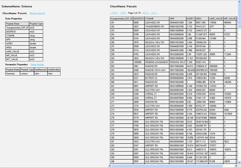
File:Data Display.JPG Screenshot view of the data from the feature class(956 × 667 (140 KB)) - 12:24, 12 December 2006- ...page is to discuss a proposal for a short project (4-7 months) looking at data quality approaches to collaborative online sources of information. This is ...ty of geographic information are oriented towards quality assurance in the data production process. They also assume that the end user will accept the prod6 KB (811 words) - 07:48, 27 October 2010
- 1 KB (194 words) - 02:02, 13 November 2013
- ...y distributable mini-package for tutorial purposes. This is much like the data packages used in MapServer workshops, for example. The goal is not to prod For example, in a typical MapServer workshop we'd have a simple set of data including:3 KB (466 words) - 18:37, 29 September 2007
- ...ormation is AWSTATS, a web analytics FOSS that provides pretty interesting data. On [http://wiki.osgeo.org/images/6/6d/Osgeo.pdf these slides], it may be e The data for February 2008 Shows that from that month there has been considerable gr4 KB (688 words) - 23:56, 5 May 2008
- #REDIRECT [[Geospatial Data]]29 bytes (3 words) - 16:10, 22 October 2008
- #REDIRECT [[KPI's and AWStat data]]35 bytes (5 words) - 03:34, 13 February 2008
- :Geospatial Data Basics :Geospatial Data Formats1 KB (137 words) - 16:10, 22 October 2008
- ...tware is suitable to publish data in compliance with the INSPIRE directive data schemas. ...rk on example use cases that demonstrate the creation of INSPIRE compliant data.3 KB (369 words) - 09:02, 18 February 2014
- ...ata models being developed by OSGeo members and supporters. All of the GIS data models listed below are released under the [http://creativecommons.org/choo The data model diagrams are being developed in Inkscape. SVG templates will be avail600 bytes (86 words) - 21:07, 16 July 2012
- #REDIRECT [[MapGuide RFC 2 - Unmanaged Data APIs]]50 bytes (7 words) - 19:11, 1 November 2006

File:Data All 170712.pdf (79 KB) - 07:17, 12 July 2017- Tanzania Data Lab is center of activity, connecting the data revolution to national priorities, global commitments and diverse programs Africa where data is frequently and effectively used to inform policy and decision making at426 bytes (63 words) - 04:52, 24 August 2018
- 297 bytes (44 words) - 04:52, 24 August 2018
- ...t put up too many barriers but helps to guarantee quality and integrity of data (or at least useful assessment of change and variation in quality) as much ...sion dedicated to data projects. But often the line drawn between code and data in a distribution is not so clear.2 KB (400 words) - 11:53, 2 December 2007

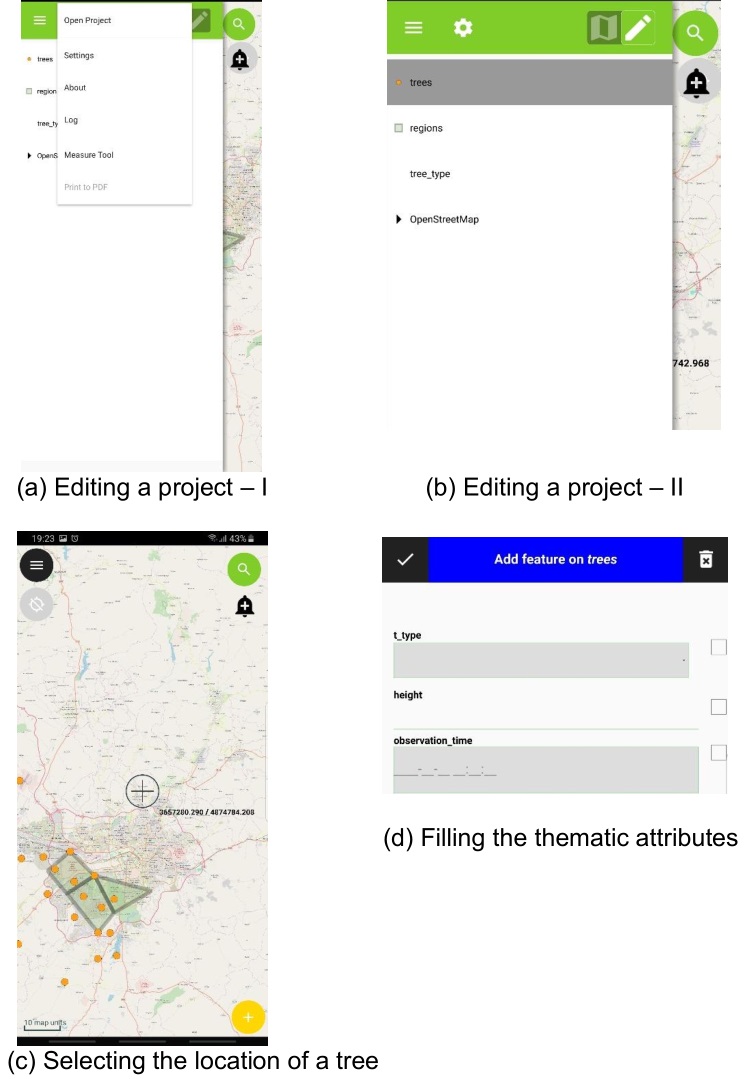
File:Qfield data collection.jpg (753 × 1,079 (122 KB)) - 14:53, 10 February 2020- ...liano Cannata and Milan Antonovic. This is the wiki of Vistsos: The istSOS Data Visualization Framework project. ...reate a customizable framework that will allow users to define and publish data visualizations charts linked with istSOS. The objective mentioned before im22 KB (3,393 words) - 05:52, 21 August 2016
- 123 bytes (18 words) - 08:39, 6 June 2016
Page text matches
- Resources for data sources and information on GIS in California. == Data ==485 bytes (66 words) - 17:12, 13 February 2009
- ...ed in 2004. It is structured like a free software foundation, but for open data projects. ...The software is being used for the data portal at [http://www.data.gov.uk/ data.gov.uk]. See also thoughts on [[Location in CKAN]]795 bytes (128 words) - 07:45, 16 January 2010
- Tanzania Data Lab is center of activity, connecting the data revolution to national priorities, global commitments and diverse programs Africa where data is frequently and effectively used to inform policy and decision making at426 bytes (63 words) - 04:52, 24 August 2018
- ...ource software for data management/storage and delivery to web as maps and data.100 bytes (17 words) - 01:10, 27 November 2008
- ...at issues authentication certificates for users and data within Geospatial Data Infrastructures.151 bytes (21 words) - 02:20, 21 April 2006
- * "States" sample data produced by Ian Turton from US Census Data.91 bytes (13 words) - 10:30, 31 December 2012
- ...additional knowledge about other technologies of software development and data analyses. Worked as land surveyor, GIS data operator, python programmer.402 bytes (53 words) - 12:14, 10 July 2016
- :Geospatial Data Basics :Geospatial Data Formats1 KB (137 words) - 16:10, 22 October 2008
- Data scientist connecting farmers with data insights. Avid R,Python,QGIS and SQL user. Love open-source materials!114 bytes (17 words) - 09:56, 20 August 2018
- == Free Data == | Canadian Geospatial Data Infrastructure || [http://www.geoconnections.ca/ link title] ||887 bytes (120 words) - 09:55, 21 September 2006
- ...tabase technology in the geospatial industry for the management of spatial data for utility and mapping applications.715 bytes (105 words) - 09:22, 4 February 2008
- ...of research in Mathematics, I turned to data science. I am co-founder and data scientist at Rockestate.117 bytes (19 words) - 10:04, 10 November 2017
- ...ata models being developed by OSGeo members and supporters. All of the GIS data models listed below are released under the [http://creativecommons.org/choo The data model diagrams are being developed in Inkscape. SVG templates will be avail600 bytes (86 words) - 21:07, 16 July 2012
- Main interest: Development and managing Spatial Data Infrastructure (SDI), WebGis, Interoperable Geoservices (OGC), Open Source ...phic Information Systems. Analysis and processing of interoperable spatial data and metadata.337 bytes (40 words) - 11:07, 2 April 2016
- ...t exists in the real world. The company leverages a variety of open source data and protocols to power their offering, and is a supporter of the open sourc549 bytes (90 words) - 11:08, 5 December 2019
- ...hallenge Manager. Background in computer vision of fluorescence microscopy data, specializing in developing deep learning models for EO imagery.191 bytes (26 words) - 01:09, 30 August 2019
- This wiki page is home to discussion about a set of standard MetaCRS test data files. These files will allow users/programmers to verify the coordinate co ...he test data files is a monolithic CSV file in which each row contains the data needed to verify a single tranformation/conversion between two (2) coordina712 bytes (113 words) - 21:13, 14 November 2009
- ...ta management for NOAA. Weather and ocean observations and forecasts open data.134 bytes (19 words) - 17:41, 18 August 2017
- ...sh Agency for Data Supply and Efficiency (sdfe.dk), processing point cloud data for the Danish Elevation Model (DK-DEM/DHM).162 bytes (26 words) - 17:39, 8 February 2018
- ...He is also a member of the Research Data Alliance Big Data and Geospatial Data groups.624 bytes (96 words) - 14:02, 25 April 2019
