Common Cartography Engine
Work in progress based on OSGeo Cartographic Library discussion.
JOIN MAILING LIST: A list is now available for discussion around these concepts/ideas: Carto list.
Goal
A high level, cross-project effort to define a cartography output specification, with an accompanying engine application or set of scripts to produce high quality printable output. Other projects could then export to this standard and share in the benefit of a common engine.
Motivation
Several GFOSS applications (both desktop and web) seek to improve hard copy print output, though approaches are often not re-usable across applications. We propose developing a common method, with reference specifications and tools, for easily pulling together high quality layout and rendering. This may occur at several levels - a Python API, command line scripts and the ability to embed functionality into an application. A central configuration file format convertor may also be developed.
This project focuses on utilities to process compliant documents. The production of a printing interchange specification/standard is needed as well. An advanced layout tool in the form of a GUI would also be very useful but for latter in the project.
Context: Mapnik
There are a variety of methods for defining printable documents and styles, etc. One well developed approach is used by the Mapnik project and will be the basis of development. Mapnik software is assumed for the base throughout the remainder of the project.
What Is Included In A Hardcopy Map?
The following components are expected to be needed, some already are defined by the Mapnik XML format, but some are not and represent new specs that are needed:
- multiple layers
- various symbols/styles
- legends
- map surrounds
- graticules/grids
- north areas
- scale bars
- inset maps
- label placement
- more...
General Workplan
- Review existing map definition standards (e.g. from a few desktop and web applications Configuration Files)
- Identify missing components from those standards.
- Create new specification or make a choice of existing one. Document the primary components as necessary for other app developers to build to its specification.
- Identify print-specific options/configuration (and challenges) needed for producing a hard copy. (see Potential Components below for an idea of overall concept)
- Write scripts to consume a compliant document and produce a output file - e.g. postscript, PDF or raster. (See discussion below re: output formats)
- If possible, write a sample GUI for one OSGeo project to use the specification.
Output Formats
These are often the tricky part when aiming for high resolution vector-based printable output. The Cairo library (that Mapnik can also use) provides several key output options that meet this need: Postscript, SVG, PDF and raster.
Postscript and PDF may be directly printable. SVG and raster output allow for post-production to be done in a 3rd party graphics editing app later in the pipeline.
End User Needs
- Print to small format medium (eg 8.5in x 11in, 11in x 14in) and large format (eg 34 x 44in)
- Interactive layout
- High quality printing
- Storage of cartographic symbolizing
- Symbols library
- Separate cartographic and geographic representation (eg changes to carto does not affect geo).
- Generalization on-the-fly, based on current scale.
- Rules based cartography stored in RDBMS (eg series 400 highways are blue with double lines)
- Multiple export formats
- Geotiff
- PNG
- PDF / GeoPDF
- Postscript (need for directly sending files to printers)
- SVG
- Layout Functionality
- Text-based configuration file that applications can output to or humans can manually hack/script
- Common, interoperable data file input options
- Customizable legend with Symbology representation (textures, object symbols, etc.)
Layout Functionality
Design Modeling
Issues of layout will always be important in creating the final cartographic product. Layout templating such as that used in Natural Resources Canada's (NRCAN) Cartographic Design Specifications (http://ess.nrcan.gc.ca/pubs/carto/downloads/design_specs.pdf#page=13).
Perhaps we can learn from the desktop publishing world from the likes of the Scribus project (http://www.scribus.net/). Maybe being able to export a certain portion to scribus to handle some the major layout hurdles. A link between the cartographic library and scribus could allow for auto generation of some layout features and text such as changing declination, Projection info, and others.
Potential Components
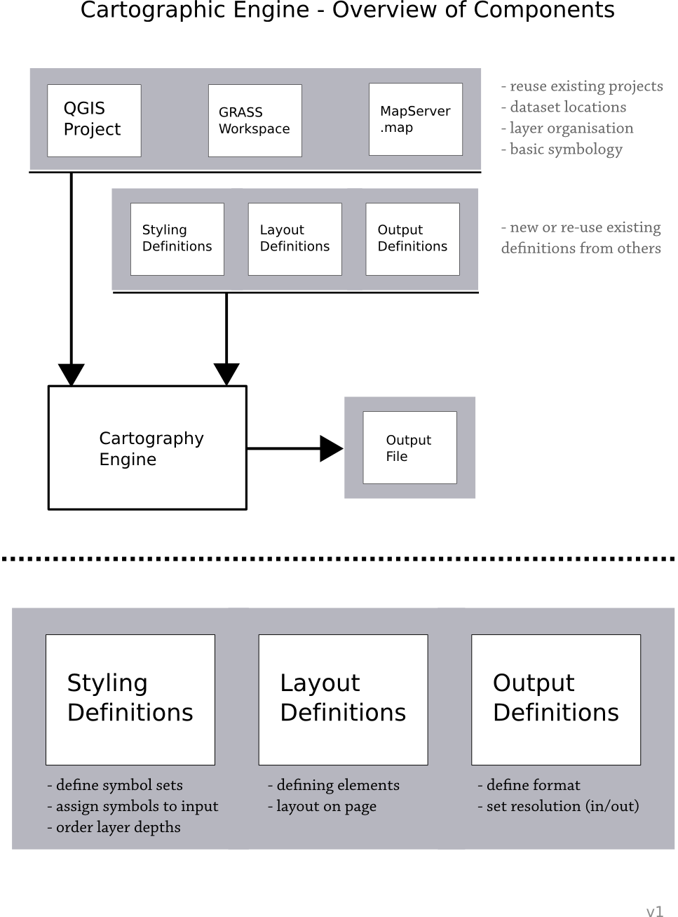
Breaking the end goal into some components will help to recognise which area(s) there is greatest need. There seems to be at least four primary components to the proposal.
Style & Layout Configuration Standards
- Specifications for styling of features and layout of a map composition
- Could re-use existing approaches where applicable (e.g. SLD, WMC, MapServer Mapfile, OGR Feature Styles)
- Specifications to be used in map definition/configuration files
Graphical Style & Layout Editor
- To create styles interactively
- To define map layout
- Could be stand-alone
- Could be adopted as part of another application
- Saves a style/layout definition document according to above standards
Graphical Map Composition Editor
- Implemented by existing applications (e.g. GRASS, QGIS, etc.)
- Sets up pointers to data layers
- Assigns styles definitions to the layers
- Applies layout definition to maps
- Outputs a map composition configuration file
Rendering Engine
- Stand-alone application (no GUI)
- Reads standard map composition configuration file
- Reads and applies the required style/layout definition documents
- Outputs final graphics to specific files
