Difference between revisions of "GeoTecWorkshop2007"
Jump to navigation
Jump to search
| Line 11: | Line 11: | ||
* Afternoon coffee break is from 3 - 4 p.m. | * Afternoon coffee break is from 3 - 4 p.m. | ||
| − | == PostGIS == | + | == Introduction (30 minutes) == |
| + | * Why Open Source | ||
| + | * The Open Source Geospatial Technology Stack | ||
| + | * Overview of the Spatial Data Management System (talk through diagram above) | ||
| + | |||
| + | == PostGIS (1 hour, 15 minutes) == | ||
* Overview, Features, Architecture | * Overview, Features, Architecture | ||
* Labs | * Labs | ||
| Line 18: | Line 23: | ||
** Execute Spatial SQL | ** Execute Spatial SQL | ||
| − | == uDig == | + | == uDig (1 hour, 15 minutes) == |
* Overview, Features, Architecture | * Overview, Features, Architecture | ||
* Labs | * Labs | ||
| Line 25: | Line 30: | ||
** View and Edit Data | ** View and Edit Data | ||
| − | == MapGuide == | + | == MapGuide (1 hour, 15 minutes) == |
* Overview, Features, Architecture | * Overview, Features, Architecture | ||
* Labs | * Labs | ||
| Line 31: | Line 36: | ||
** Connect to PostGIS | ** Connect to PostGIS | ||
** Create Layers/Maps | ** Create Layers/Maps | ||
| − | ** View | + | ** View Application on the Web |
| + | ** View Map in Google Earth | ||
** Customize Application? | ** Customize Application? | ||
| − | == FUSION == | + | == FUSION (1 hour, 15 minutes) == |
* Overview, Features, Architecture | * Overview, Features, Architecture | ||
* Labs | * Labs | ||
Revision as of 13:35, 24 April 2007
Abstract
This workshop features the creation of a complete spatial data management system using only open source components. The course materials will provide an overview of the PostGIS/PostgreSQL spatial database, uDig desktop GIS application, MapGuide Open Source Web mapping platform, and the FUSION AJAX framework. Participants will have an opportunity to install the software, load demonstration data, publish cartographic maps to the Web, use the desktop application to view and edit the spatial information, and publish the live data to Google Earth, all on their own laptop.
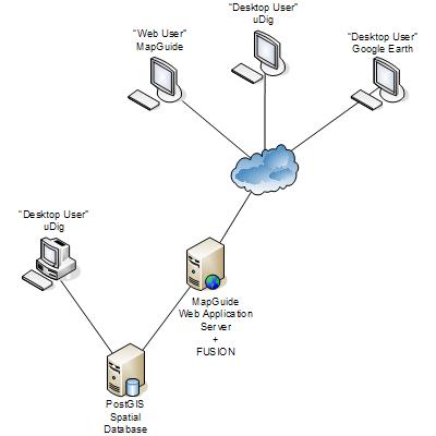
Spatial Data Management System

Outline
Workshop runs from: 9 a.m. to 5 p.m.
- Coffee will be supplied starting at 8:30 a.m.
- Boxed lunch from 12:30 - 1:30.
- Afternoon coffee break is from 3 - 4 p.m.
Introduction (30 minutes)
- Why Open Source
- The Open Source Geospatial Technology Stack
- Overview of the Spatial Data Management System (talk through diagram above)
PostGIS (1 hour, 15 minutes)
- Overview, Features, Architecture
- Labs
- Install Postgres/PostGIS
- Load Data Set
- Execute Spatial SQL
uDig (1 hour, 15 minutes)
- Overview, Features, Architecture
- Labs
- Install uDig
- Connect to PostGIS
- View and Edit Data
MapGuide (1 hour, 15 minutes)
- Overview, Features, Architecture
- Labs
- Install MapGuide
- Connect to PostGIS
- Create Layers/Maps
- View Application on the Web
- View Map in Google Earth
- Customize Application?
FUSION (1 hour, 15 minutes)
- Overview, Features, Architecture
- Labs
- Install FUSION / Hack MapGuide?
- Create a Custom Layout?
- ???