GeoForAll OSGeo Relationship
Redirect page
Redirect to:
| DRAFT |
|---|
| This page is a DRAFT document subject to discussion and OSGeo board approval |
Purpose of Document
The OSGeo Board of Directors would like to clarify the relationship between the Geo4All initiative, and the OSGeo foundation, in terms of promoting education. The intended audience of this document is the Geo4All community. This document outlines a few possible scenarios, of how the Geo4All group can work with the OSGeo foundation.
About Geo4All
The Geo4All initiative that started off after the signing of an MoU (see http://wiki.osgeo.org/wiki/MOU_ICA) between OSGeo and the International Cartographic Association (ICA) has been growing at a rapid pace since 2011. Geo4All expanded in 2014 with the addition of the International Society for Photogrammetry and Remote Sensing (ISPRS).
One of the initiatives championed by Geo4All, is the setting up of “ICA-ISPRS-OSGeo Labs” worldwide which presently includes 102 labs[1]. In a recent survey conducted by Maria Brovelli and Peter Mooney, 35 labs have responded to questionnaire concerning their activities.
The Geo4All initiative has an Advisory Board co-chaired by Presidents of OSGeo and ICA and comprised majority of members who are also Charter Members of OSGeo. Geo4All operates its own website, has its own logo and publishes its own Newsletter. As a main mode of communication, Geo4All utilizes the OSGeo listserver and wiki.
About International Cartographic Association
International Cartographic Association (ICA) is the world authoritative body for cartography and GIScience
International Society for Photogrammetry and Remote Sensing
The International Society for Photogrammetry and Remote Sensing (ISPRS) is a non-governmental organisation devoted to the development of international cooperation for the advancement of photogrammetry and remote sensing and their applications.
About Open Source Geospatial Foundation
Open Source Geospatial Foundation (OSGeo) is not-for-profit organization whose mission is to support the collaborative development of open source geospatial software, and promote its widespread use (see about).
OSGeo has an “Education and Curriculum Committee” chaired by VP, (Vice President) Education and Curriculum Project (presently Charlie Schweik; see http://www.osgeo.org/content/foundation/board_and_officers.html) and main channel of communications is the edu_discuss mailing list and OSGeo Wiki. The mailing list is not active with few stray mails coming at an irregular pace and the “Education and Curriculum Committee” Wiki does not reflect the existence of such a committee within the OSGeo Foundation.
Current Status
The discussions on the Geo4All ML, at the video conference among Geo4All enthusiasts and at the Geo4All BoF held in Como led to the agreement among the OSGeo education committee chair and several OSGeo members also actively involved in Geo4All initiative that, “GeoForAll: OSGeo's Education and Curriculum Effort” (http://www.osgeo.org/ education) is the new avatar of the former “Education and Curriculum Committee”.
Geo4All had been working hard to expand OSGeo education activities globally . Members have been running courses, training events, workshops, webinars, summer schools etc using OSGeo software, MOOC programs (that benefitted thousands of students globally) etc have raised OSGeo education efforts globally. Geo4All members have been actively contributing to OSGeo Curriculum development effort and will continue to expand this by having more course materials in various OSGeo software aded to the OSGeo education repository for everyone to make use of for their teaching and education.
Requirements of OSGeo
OSGeo needs a committee/initiative/group that is focused on promoting "collaborative development of open source geospatial software, and promote its widespread use" through education. Students and researchers need to know how to benefit from the great open source projects and how to participate in these projects and the open source community.
Participation
We expect GeoForALL activities to promote participation - here are examples from a range of organizations:
- Course materials on NASA World Wind make note of forums and particpation in goworldwind.org
- Course material on R makes note of the R FAQ and mailing list and a blurb on open source participation and the R Foundation.
- Course material on QGIS make note of the QGIS users page, how to get involved in the QGIS.org association.
- Course materials on GeoServer link to the communication page along with information on the OSGeo Foundation.
NOTE: The examples clearly show that OSGeo projects are in no way singled out for special treatment. We are asking that the participation message of Open Source be showcased. This message is of vital importance, as any advocacy of use that is not balanced by participation does our students (and open source projects) a disservice.
Requirements of Geo4All
1. Geo4All initiative was started with the key aim to build up OSGeo's education aims by collaborating with like minded organisations and it is one of the most successful initiatives that we have undertaken. OSGeo Board has made separate MoUs with both ICA and ISPRS for expanding Geo4All and universities,SMEs, government organisations etc worldwide have trusted the MoUs that OSGeo provided and setup labs and joined the network , so it is important we provide strong continuity and focus. MoUs have to be respected and the momentum created need to build upon with clear direction and focus.
2. We will welcome and include all partners that OSGeo Board have MOUs with for expanding this OSGeo' Geo4All education initiative and warmly welcome everyone who are following the principles. That way the OSGeo Board will be able to keep expanding the initiative and to make MoUs with other organisations etc as we are doing now (ICA, ISPRS) and also in future .
Recently through mailing list discussions, we had discussion on the future directions for Geo4All .There were different opinions and hence we arranged a meeting at Como to discuss this and find a way forward. Following lot of discussions among our members in our mail lists and the meeting at Como[1] that was led by Charlie Schweik, the consensus was that OSGeo Education and Curriculum Committee and GeoForAll are the same and it is now GeoForAll: OSGeo's Education and Curriculum Effort as reflected in OSGeo website at http://www.osgeo.org/education. Venka has also presented this outcome at FOSS4G Seoul [2].
So steps need to be taken to ensure the smooth transition to GeoForAll as OSGeo's Education and Curriculum Effort, to make sure the efforts put in by lot of volunteers for this is build upon for the future.
3. Geo4All will continue to be inclusive and include all partners that OSGeo Board have MOUs with for expanding this OSGeo' Geo4All education initiative and warmly welcome everyone who are following the principles.
[1] http://wiki.osgeo.org/wiki/FOSS4G_EU_Como_2015_Preconference_meeting
[2] http://www.slideshare.net/VenkateshRaghavan1/g4-a-newver2
What Must Happen
As a foundation, OSGeo needs to provide a clear picture about relation/role of the Geo4All initiative, and the Geo4All Advisory Board need to confirm its stance vis-à-vis the OSGeo Foundation.
How to Get There
Three possible scenarios could be considered as regards the synergy between OSGeo Foundation and Geo4All initiative.
Scenario 1:
OSGeo Board of Directors and the Geo4All Advisory Board mutually agree that Geo4All is the “official” educational outreach of OSGeo Foundation.
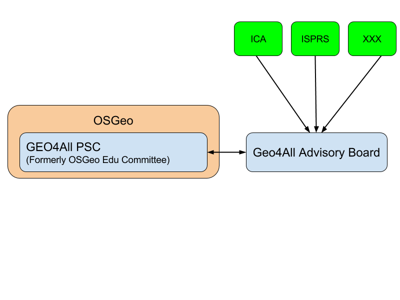
Figure 1: Organization Structure of Scenario 1
In this case, the Geo4All Advisory Board would include representatives from our partners like ICA, ISPRS etc. Geo4All Advisory Board comprises of representatives from ICA, ISPRS, OSGeo and other organization that join in future. As a partner in the Geo4All initiative, a Project Steering Committee (PSC) comprising of VP OSGeo Foundation (Education and Curriculum Project) and other representatives (e.g Regional Chairs of Geo4All) need to be constituted within the OSGeo Foundation. The PSC could liaise with Geo4All Advisory Board to evolve way and means to achieve mutual goals and objectives.
Scenario 1B:
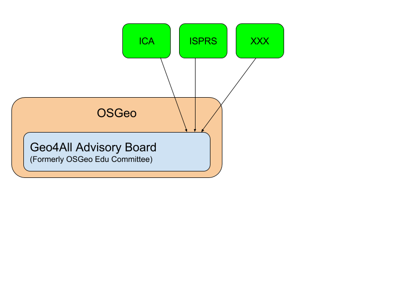
Similar to Scenario 1, OSGeo Board of Directors and the Geo4All Advisory Board mutually agree that Geo4All is the “official” educational outreach of OSGeo Foundation, but no new structure (PSC, committee or whatever) would be created in OSGeo.
Figure 1b: Organization Structure of Scenario 1b
Geo4All operates with a focus on strongly promoting the open source projects through education, by holding events, presentations, papers, training sessions, awards, etc. Note that in this scenario Geo4All Advisory Board would name an officer who would liaise with the OSGeo community (as every other OSGeo committee does).
Scenario 2:
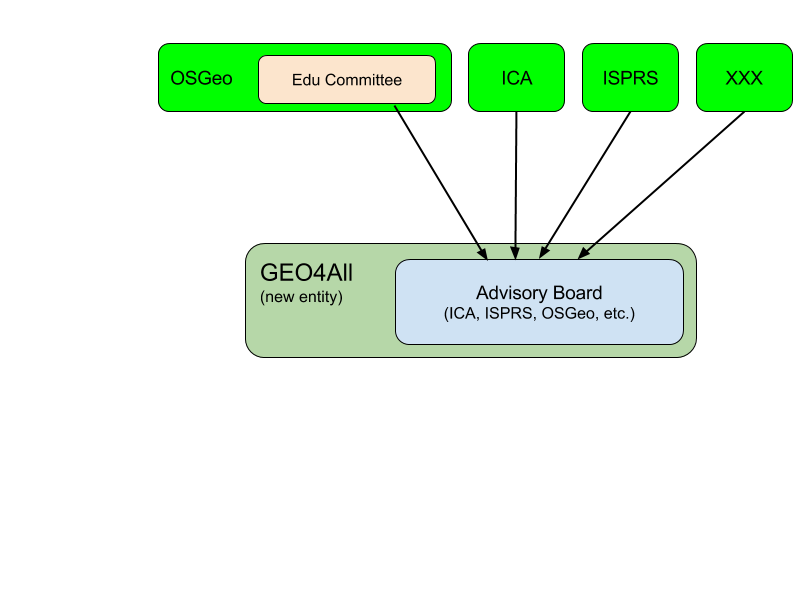
Geo4All, an independent entity working closely with the OSGeo Foundation.
Figure 2: Organization Structure of Scenario 2
Geo4All could be something for “open Geospatial education” what OSM is for “open geospatial data”. This requires forming a seperate legal entity. Such a decision is for Geo4All advisory board to take and also propose some kind of MoU with the OSGeo Foundation to spread “open Geospatial education” using the resources of the OSGeo Foundation.
Scenario 3:
We do not think that a third scenario exists.
Resolution
Based on the clarification of this relationship (Scenario 1, Scenario 1B, or Scenario 2) both the OSGeo Board of directors and Geo4All Advisory Board should officially approve the new relation/role of OSGeo and Geo4All:
- OSGeo would take appropriate steps (update web site etc.) to reflect the correct picture both inside and outside of the OSGeo Foundation.
- Geo4All also would need to update its website, newsletter etc. to reflect being a part of OSGeo Foundation or teaming with OSGeo Foundation along with other organizations.
Further Discussion
The following discussion, while off-topic for the above scenarios, warrant further discussion by the Geo4All Advisor Board:
It the case of Scenario 1, several things need to be considered for example
- Should the “ICA-OSGeo Labs” simply be named as “Geo4All-Labs”? We think that the organizations partnering with OSGeo Foundation’s educational outreach will grow in the future. Would it be feasible to add organizational abbreviations to the Labs e.g. “ICA-ISPRS-XXX-YYY-ZZZ-OSGeo Labs”?. The OSGeo Advisory board has agreed that this was not feasible and proposed a Geo4All “Partners” category to list organizations affiliated to Geo4All.
- Geo4All focus on open source projects should be in writing, documented on the Geo4All website and also on the OSGeo website.
- In case of Scenario 2 (since Education is an important outreach initiative for the OSGeo Foundation) a proper “Education and Curriculum Committee” needs to be re-established whose main role would be to liaise and work jointly with Geo4All to fulfill the OSGeo mission in the sphere of Education and academic Research
- In case of Scenario 2 a new legal entity would be required for Geo4All.
Notes
- ↑ 105 in the minus 3 marked "to be replaced" (see http://www.geoforall.org/locations/) which were never really contacted. We have identified around 20 which were not responsive or did not have valid contact so the realistic number of the labs is 70-80.


