Search results
Jump to navigation
Jump to search
Page title matches
- ...sion of field data from geopaparazzi projects to WebGIS platform enabling data analysis and sharing. The project will demonstrate and document the methods ...already used by some desktop GIS and toolkits. And currently geopaparazzi data can be exported to some desktop GIS clients like GRASS, QGIS, gvSIG. STAGE6 KB (880 words) - 17:13, 2 May 2016
- ...ormation is AWSTATS, a web analytics FOSS that provides pretty interesting data. On [http://wiki.osgeo.org/images/6/6d/Osgeo.pdf these slides], it may be e The data for February 2008 Shows that from that month there has been considerable gr4 KB (688 words) - 23:56, 5 May 2008
- #REDIRECT [[Geospatial Data]]29 bytes (3 words) - 16:10, 22 October 2008
- #REDIRECT [[KPI's and AWStat data]]35 bytes (5 words) - 03:34, 13 February 2008
- :Geospatial Data Basics :Geospatial Data Formats1 KB (137 words) - 16:10, 22 October 2008
- ...white paper. Pleas join forces and help to shape the understanding of Open Data.''''' ...the live version of a white paper collating definitions of the term "Open Data" applied to the geospatial domain.''11 KB (1,713 words) - 02:02, 13 November 2013
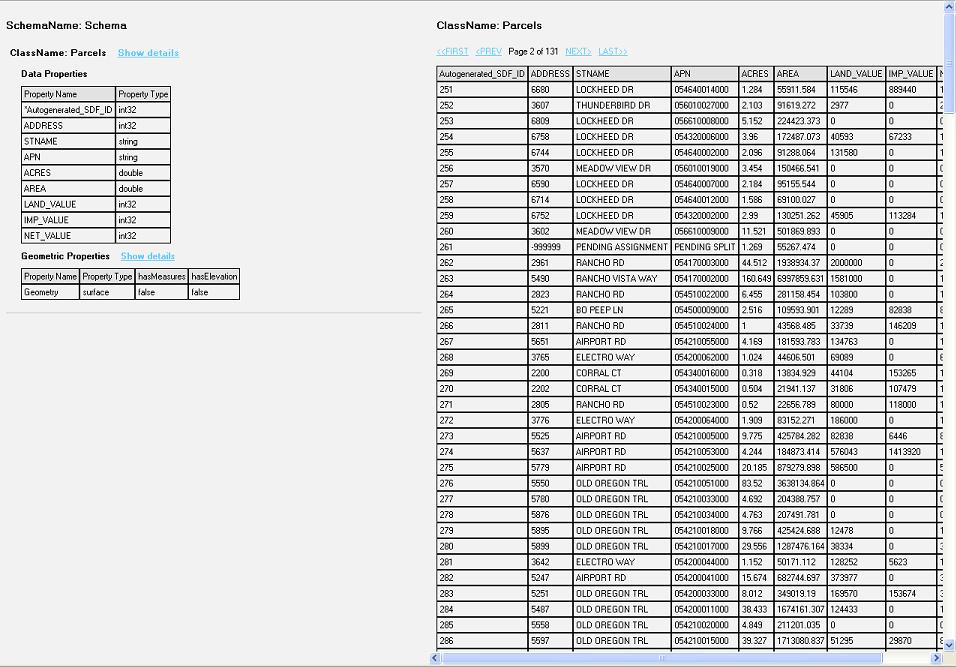
File:Data Display.JPG Screenshot view of the data from the feature class(956 × 667 (140 KB)) - 12:24, 12 December 2006- ...page is to discuss a proposal for a short project (4-7 months) looking at data quality approaches to collaborative online sources of information. This is ...ty of geographic information are oriented towards quality assurance in the data production process. They also assume that the end user will accept the prod6 KB (811 words) - 07:48, 27 October 2010
- 1 KB (194 words) - 02:02, 13 November 2013
- ...y distributable mini-package for tutorial purposes. This is much like the data packages used in MapServer workshops, for example. The goal is not to prod For example, in a typical MapServer workshop we'd have a simple set of data including:3 KB (466 words) - 18:37, 29 September 2007
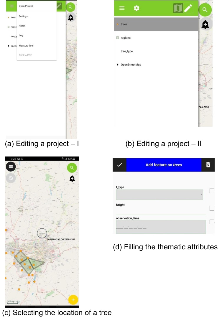
File:Qfield data collection.jpg (753 × 1,079 (122 KB)) - 14:53, 10 February 2020- ...tware is suitable to publish data in compliance with the INSPIRE directive data schemas. ...rk on example use cases that demonstrate the creation of INSPIRE compliant data.3 KB (369 words) - 09:02, 18 February 2014
- ...ata models being developed by OSGeo members and supporters. All of the GIS data models listed below are released under the [http://creativecommons.org/choo The data model diagrams are being developed in Inkscape. SVG templates will be avail600 bytes (86 words) - 21:07, 16 July 2012
- #REDIRECT [[MapGuide RFC 2 - Unmanaged Data APIs]]50 bytes (7 words) - 19:11, 1 November 2006

File:Data All 170712.pdf (79 KB) - 07:17, 12 July 2017- Tanzania Data Lab is center of activity, connecting the data revolution to national priorities, global commitments and diverse programs Africa where data is frequently and effectively used to inform policy and decision making at426 bytes (63 words) - 04:52, 24 August 2018
- 297 bytes (44 words) - 04:52, 24 August 2018
- ...t put up too many barriers but helps to guarantee quality and integrity of data (or at least useful assessment of change and variation in quality) as much ...sion dedicated to data projects. But often the line drawn between code and data in a distribution is not so clear.2 KB (400 words) - 11:53, 2 December 2007
- This page includes information about a new sample data set provided for software testing and development of educational materials The [http://www.grassbook.org/data_menu3rd.php modern North Carolina based data set] aims to replace the [http://grass.itc.it/download/data6.php GRASS Spea10 KB (1,422 words) - 09:35, 11 January 2008
- == Discussion around GIS data formats ==189 bytes (22 words) - 05:03, 2 March 2012
- 96 bytes (16 words) - 20:55, 15 March 2007
- ...liano Cannata and Milan Antonovic. This is the wiki of Vistsos: The istSOS Data Visualization Framework project. ...reate a customizable framework that will allow users to define and publish data visualizations charts linked with istSOS. The objective mentioned before im22 KB (3,393 words) - 05:52, 21 August 2016
- 123 bytes (18 words) - 08:39, 6 June 2016
- Each year the OSGeo California Chapter give the Open Geospatial Data Award to one organization in California. (You can also nominate organizatio ...d other organizations that are promoting open access to quality geospatial data.2 KB (272 words) - 08:15, 16 January 2013
File:Gav grass public geo data manifesto.jpg (850 × 787 (116 KB)) - 08:01, 3 February 2007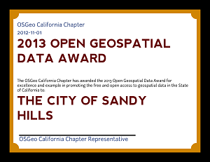
File:Example Open Geospatial Data Award.png (300 × 231 (22 KB)) - 16:06, 7 December 2012- 134 bytes (27 words) - 09:13, 21 June 2007
- There is an [[Public Geospatial Data Committee|official foundation committee]] page which provides more detail o ...st-practise guidelines and examples for use of open and free standards for data (GML, WMS, WFS-T) and metadata (Dublin Core, RDF, ISO19115 through ISO1913910 KB (1,458 words) - 10:12, 22 January 2013
- Pages regarding the Public Geospatial Data Committee63 members (0 subcategories, 0 files) - 08:31, 23 August 2007
- See [[Public Geospatial Data Project]] * [[Public Geospatial Data Project]]4 KB (443 words) - 18:39, 5 December 2010
- This wiki page is home to discussion about a set of standard MetaCRS test data files. These files will allow users/programmers to verify the coordinate co ...he test data files is a monolithic CSV file in which each row contains the data needed to verify a single tranformation/conversion between two (2) coordina712 bytes (113 words) - 21:13, 14 November 2009
- ...ich will be used. If we make it a significant project to just to parse the data and use the test results, it will not get used. In this regard: ...to make it as easy as possible for a test application developer to use the data file.3 KB (446 words) - 10:42, 5 November 2009
- Natural Earth Data (http://www.naturalearthdata.com/)233 bytes (30 words) - 08:17, 16 January 2013
- ...e purpose of refining the Mission Statement of the OSGeo Public Geospatial Data Project. ...those statements that you feel should not be part of the Public Geospatial Data Project. Don't hesitate to add any statements that conflict or contradict a9 KB (1,446 words) - 09:55, 9 December 2007

File:1 5 Defining the Data Model.odt (29 KB) - 23:30, 24 March 2011File:Virtual Data Help Desk at EGU20 202004301617 150dpi.pdf (1.84 MB) - 02:18, 23 February 2022- '''Civic apps and State data''' - what data sets does the state have that would be interesting to app developers?3 KB (488 words) - 06:13, 18 November 2014
- * data - any spatial data required for your workshop707 bytes (105 words) - 15:49, 1 September 2009
- == How to download sample data == ...till isn't fully decided on. In the meantime, you can download some sample data by following these steps:8 KB (1,172 words) - 01:01, 12 August 2010
File:1 2 (part2) Manipulating the Data Bank.odt (31 KB) - 23:24, 24 March 2011- ...ill enable an application developer to perform a transaction in a pygeoapi data provider through an HTTP request containing the resource id and suitable HT ...' of this OGC standard. It adds transactional capabilities to the pygeoapi data providers by which application developers can perform transactions via the9 KB (1,329 words) - 05:12, 31 August 2020
File:1 2 Manipulating Data Bank in SPRING.odt (13 KB) - 23:24, 24 March 2011- ...S services using the ZOO-Project. Yet it is not capable of grabbing sensor data and publishing. On the other hand, istSOS which is an OGC SOS server implem ...s and OGS standard services such as WMS, WFS,WMTS and WPS by utilizing the data from istSOS. The provided datasets and services (WMTS,WMS, etc) can be depl8 KB (1,349 words) - 20:59, 30 August 2017
File:2 6 Vectorial data manipulation in the SPRING.odt (69 KB) - 23:31, 24 March 2011- | This is where I'll be posting information about istSOS-Data analysis and statistical tools suite GSoC 2017 project to the OSGeo communi <b>istSOS</b> is sensor data management tool that allows collection, maintenance and publishing of monit13 KB (1,943 words) - 17:35, 20 August 2017
File:Conversion of an ARC-INFO Coverage Containing Multipe Attribute Data to a MOSS.pdf (1.94 MB) - 02:17, 11 June 2019- ...uce a new raster file. This project aim is to develop a new virtual raster data provider that can help to use the raster calculator without creating a lot * Prototype the new virtual raster data provider with some basic methods, add the new provider to the provider regi18 KB (3,030 words) - 23:09, 19 August 2021
- ..., recording photos and developing a web-interface to display the collected data. There are several cloud based application development platforms and this t ...and S. Coetzee. 2020. ‘Educational Material Development on Mobile Spatial Data Collection Using Open Source Geospatial Technologies’. Pp. 221–27 in Th43 KB (6,692 words) - 13:50, 30 April 2023


Page text matches
- Resources for data sources and information on GIS in California. == Data ==485 bytes (66 words) - 17:12, 13 February 2009
- ...ed in 2004. It is structured like a free software foundation, but for open data projects. ...The software is being used for the data portal at [http://www.data.gov.uk/ data.gov.uk]. See also thoughts on [[Location in CKAN]]795 bytes (128 words) - 07:45, 16 January 2010
- Tanzania Data Lab is center of activity, connecting the data revolution to national priorities, global commitments and diverse programs Africa where data is frequently and effectively used to inform policy and decision making at426 bytes (63 words) - 04:52, 24 August 2018
- ...ource software for data management/storage and delivery to web as maps and data.100 bytes (17 words) - 01:10, 27 November 2008
- ...at issues authentication certificates for users and data within Geospatial Data Infrastructures.151 bytes (21 words) - 02:20, 21 April 2006
- * "States" sample data produced by Ian Turton from US Census Data.91 bytes (13 words) - 10:30, 31 December 2012
- ...additional knowledge about other technologies of software development and data analyses. Worked as land surveyor, GIS data operator, python programmer.402 bytes (53 words) - 12:14, 10 July 2016
- :Geospatial Data Basics :Geospatial Data Formats1 KB (137 words) - 16:10, 22 October 2008
- Data scientist connecting farmers with data insights. Avid R,Python,QGIS and SQL user. Love open-source materials!114 bytes (17 words) - 09:56, 20 August 2018
- == Free Data == | Canadian Geospatial Data Infrastructure || [http://www.geoconnections.ca/ link title] ||887 bytes (120 words) - 09:55, 21 September 2006
- ...tabase technology in the geospatial industry for the management of spatial data for utility and mapping applications.715 bytes (105 words) - 09:22, 4 February 2008
- ...of research in Mathematics, I turned to data science. I am co-founder and data scientist at Rockestate.117 bytes (19 words) - 10:04, 10 November 2017
- ...ata models being developed by OSGeo members and supporters. All of the GIS data models listed below are released under the [http://creativecommons.org/choo The data model diagrams are being developed in Inkscape. SVG templates will be avail600 bytes (86 words) - 21:07, 16 July 2012
- Main interest: Development and managing Spatial Data Infrastructure (SDI), WebGis, Interoperable Geoservices (OGC), Open Source ...phic Information Systems. Analysis and processing of interoperable spatial data and metadata.337 bytes (40 words) - 11:07, 2 April 2016
- ...t exists in the real world. The company leverages a variety of open source data and protocols to power their offering, and is a supporter of the open sourc549 bytes (90 words) - 11:08, 5 December 2019
- ...hallenge Manager. Background in computer vision of fluorescence microscopy data, specializing in developing deep learning models for EO imagery.191 bytes (26 words) - 01:09, 30 August 2019
- This wiki page is home to discussion about a set of standard MetaCRS test data files. These files will allow users/programmers to verify the coordinate co ...he test data files is a monolithic CSV file in which each row contains the data needed to verify a single tranformation/conversion between two (2) coordina712 bytes (113 words) - 21:13, 14 November 2009
- ...ta management for NOAA. Weather and ocean observations and forecasts open data.134 bytes (19 words) - 17:41, 18 August 2017
- ...sh Agency for Data Supply and Efficiency (sdfe.dk), processing point cloud data for the Danish Elevation Model (DK-DEM/DHM).162 bytes (26 words) - 17:39, 8 February 2018
- ...He is also a member of the Research Data Alliance Big Data and Geospatial Data groups.624 bytes (96 words) - 14:02, 25 April 2019
- * [http://www.freeearthfoundation.com/ Free Earth Foundation] (WorldWind data access effort) * [http://www.madmappers.com/ MadMappers] (Africa GIS data effort)1 KB (188 words) - 08:41, 23 August 2007
- ...work as an aggregation and data delivery service where different types of data can coexist and interact for multiple purposes, e.g. large ecosystem manage675 bytes (100 words) - 16:04, 17 November 2009
- === Data ===412 bytes (49 words) - 09:41, 18 September 2007
- ...interested in how new online technologies can help to share archaeological data. - Enabling MIDAS XML standards for data exchange505 bytes (87 words) - 07:37, 24 September 2006
- | '''Job title''' || Geospatial data consultant, PhD candidate / Visiting Scientist ...ndly, scalable data services can be set up based on cloud services and Big Data technologies.1 KB (177 words) - 07:11, 29 September 2019
- KML supports besides vector also raster data, so there are four areas to cover: * write vector data (already implemented)796 bytes (125 words) - 07:25, 28 February 2011
- * How metadata collecting interface is holding up to peoples data hosting reqs. * Assessment of what data sets are available now1 KB (167 words) - 08:34, 23 August 2007
- * knows about various types of geospatial data and their usability in hydrological analysis * is able to delineate watersheds from terrain data and understands uncertainties involved in such a procedure2 KB (216 words) - 12:17, 11 April 2007
- ...g, and data-fusion product generation for true color RGB and hyperspectral data collected for the National Coastal Mapping Program (NCMP) with the Coastal431 bytes (63 words) - 14:46, 20 July 2017
- : ''The theme for this conference is Spatial Data Infrastructure Convergence: Building SDI Bridges to Address Global Challeng ...re ever evolving and exciting new approaches to the offering of geographic data and services in meeting real world needs.''1 KB (143 words) - 13:48, 14 July 2009
- * Grass path not pointing to folder with example data * path to example data on welcome page is incorrect394 bytes (55 words) - 03:57, 17 April 2009
- ...ap.org OpenCycleMap.org] - an award-winning customisation of OpenStreetMap data for cyclists ....cloudmade.com CloudMade] - providing innovative services on OpenStreetMap data485 bytes (67 words) - 07:07, 26 September 2008
- ...t put up too many barriers but helps to guarantee quality and integrity of data (or at least useful assessment of change and variation in quality) as much ...sion dedicated to data projects. But often the line drawn between code and data in a distribution is not so clear.2 KB (400 words) - 11:53, 2 December 2007
- ...eospatial software at your event. The second is our annual Open Geospatial Data Award. == Open Geospatial Data Award ==1 KB (160 words) - 17:03, 7 December 2012
- ...DataObject. A DataObject is simply a collection of named attributes whose data types and values match a schema. A DataObject can be used to represent a Si ...llowing programmers to work together on lower levels of the stack, such as data access.2 KB (359 words) - 13:31, 14 November 2007
- == Workshop Data Load == ...shop will be added to all workshop computers to provide installers, sample data, instructions, presentation slides and anything else workshop instructors w773 bytes (111 words) - 03:20, 13 February 2015
- ...e. The Geochicas initiative aims to bring more women to collaborate in the data creation of OpenStreetMap and promote more women participation and knowledg ...y players. Currently she is involved in Open Data, Autonomous vehicles and data analysis initiatives.728 bytes (100 words) - 03:27, 10 October 2018
- Geospatial Data Manager ...dents. He is involved in international data standards regarding geospatial data transmission through the Commission for the Management and Application of G1 KB (167 words) - 09:24, 31 July 2007
- == Personal data ==850 bytes (108 words) - 09:25, 25 June 2009
- = Public Geospatial Data Committee Meeting #4 = ...sgeo.org/servlets/ReadMsg?list=geodata&msgNo=44 Markus' recent email about data setup]899 bytes (120 words) - 08:33, 23 August 2007
- Each year the OSGeo California Chapter give the Open Geospatial Data Award to one organization in California. (You can also nominate organizatio ...d other organizations that are promoting open access to quality geospatial data.2 KB (272 words) - 08:15, 16 January 2013
- ...y distributable mini-package for tutorial purposes. This is much like the data packages used in MapServer workshops, for example. The goal is not to prod For example, in a typical MapServer workshop we'd have a simple set of data including:3 KB (466 words) - 18:37, 29 September 2007
- = Public Geospatial Data Committee = * First [[Edu Data Package North Carolina|OSGeo Educational data set]] available1 KB (207 words) - 13:23, 10 February 2008
- |JobTitle=Environmental Data Scientist ...rsity of Auckland]. I'm interested in knowledge discovery, data mining and data representation as it applies to the Geosciences.620 bytes (86 words) - 03:57, 18 August 2020
- ...en Data Institute(ODI) certified Open Data Trainer and she volunteers as a data trainer and mentor with tech hubs in Tanzania. The desire to impact lives t989 bytes (158 words) - 08:51, 2 August 2018
File:04 knudsen.pdf ...r scanned DEMs. The approach used is independent of navigational (GPS/INS) data and ground control points. ...d gridding program for scattered geodata. It uses a simple, but efficient, data management technique to speed up the gridding procedure.(1.64 MB) - 18:45, 21 October 2009- ...to present potentially disparate/incomplete and otherwise varying sets of data in a manner which satisfies all possible parameters for its use, within rea ...data does not present itself since the reduction of high-resolution analog data to a low-resolution (technically digital, but treated as analog) representa3 KB (461 words) - 21:29, 20 May 2008
- DATA "data/day_clouds.tif" DATA "data/countries_simpl.shp"879 bytes (115 words) - 12:01, 2 September 2022
- An introductory course on web mapping and geospatial data infrastructures. Up: [[Educational Resources]] * web communities, collecting and sharing geospatial data2 KB (228 words) - 08:20, 9 December 2006
- ...iversity, Boston, MA. As part of my research I am involved with geospatial data and analysis and very excited to do research, collaborate, and develop soft268 bytes (44 words) - 22:20, 15 August 2017
- - Aggregated data visualization - http://visualitzation.eoapps.eu - Poster: Innovative ways of visualizing meta data using the open source libraries on the BiDS16 conference596 bytes (88 words) - 08:37, 24 March 2016
- This is a project of the [[Public Geospatial Data Committee]] ...geodata]], it would be good to offer maintained packages of high-quality data and metadata for education and demonstration that can be used by the softwa3 KB (431 words) - 18:32, 29 September 2007
- == Personal data ==916 bytes (113 words) - 09:47, 25 June 2009
- 2) Autodesk Mapguide Enterprise version 2007-2010 (connect spatial data through FDO) 3) Mapguide OpenSource version 2.0 (connect spatial data through FDO)794 bytes (106 words) - 15:40, 13 March 2010
- ...cumented on the wiki at [[Geodata Repository]], particularly MartinSpott's data integration work for flightgear. How to get a UI up quickly or connect bett [[Category:Public Geospatial Data Committee]]1 KB (156 words) - 08:35, 23 August 2007
- entitled "Opening Spatial Databases for Data Quality Certification". His presentation discussed the importance of spatial data quality and how, by2 KB (260 words) - 15:49, 26 March 2008
- ...r 5 years of experience living and working in sub-Saharan Africa. Advanced data management and analytic skills with specialty in visualization of complex l1 KB (172 words) - 00:05, 26 August 2019
- * research and development of radar data processing chain * data accumulation of remote sensing measurement systems260 bytes (34 words) - 07:50, 22 July 2016
- ...asets, samplers, transforms, and pre-trained models specific to geospatial data. ...is to make it simple: for machine learning experts to work with geospatial data, and for remote sensing experts to explore machine learning solutions.1 KB (165 words) - 22:06, 5 May 2024
- == DLS data == ** https://www.geosask.ca/Portal/ (go to the Pre-packaged Data Gallery)2 KB (260 words) - 09:42, 7 July 2010
- ...formats. It also comes with a variety of useful commandline utilities for data translation and processing. ...n, ILWIS, MapGuide and ArcGIS. GDAL/OGR is the most widely used geospatial data access library.1 KB (187 words) - 06:22, 8 November 2010
- ...on Spatial Data Infrastructures, web / mobile GIS development, Geospatial Data Analysis, Computer Vision and Deep learning.335 bytes (47 words) - 06:57, 14 March 2020
- ...ting and cataloging two petabytes of satellite imagery with a cloud-native data pipeline. ...ttps://developmentseed.org - solving the worlds hardest problems with open data and open technology.373 bytes (57 words) - 12:30, 31 March 2020
- * Dynamic data driven websites and back office intranet systems in asp, javascript and rel * Specific interest in UK Fire & Rescue Service mobile data, operational intelligence and mapping solutions517 bytes (71 words) - 00:39, 30 January 2009
- ....govt.nz/search/category/topographic/ LINZ Data Service], write about open data and tools in our [https://medium.com/on-location On Location] publication a691 bytes (96 words) - 05:57, 30 August 2019
- :4. Open Data 3. Geospatial Data3 KB (327 words) - 12:18, 31 October 2007
- * Without data, Open Source Geospatial Software isn't much use. ...ing and search; the [[Geodata Packaging Working Group]] needs high-quality data and metadata to produce [[Education_and_Curriculum_Committee|educational]]3 KB (508 words) - 12:58, 22 June 2006
- ...or indoor robotics. I make maps using SLAM along with user provided vector data to facilitate robotic work in factories and warehouses. I also love and fre312 bytes (53 words) - 23:38, 28 August 2019
- I work on data analysis. Most common tasks are the analysis of relevant data using statistical methods and the display of events in space and time. Henc274 bytes (51 words) - 11:46, 22 August 2016
- ...data distribution and search frontend, and developing dynamic packaging of data from OGC web services. * Data wrangling - work on getting data into good form and clean for redistribution. Including filling holes in SRT2 KB (393 words) - 13:38, 10 October 2007
- ...t Director of Data Management. Prior to this, he managed the oceanographic data collected by OTN’s autonomous underwater/surface vehicles. ..., and written a Python library to decode and handle a purpose-built binary data compression format in use on autonomous underwater vehicles.1,020 bytes (151 words) - 06:29, 28 November 2018
- This is a project started by the [[Public Geospatial Data Committee]] ...ata licensing, both of community-contributed and state-collected bodies of data.3 KB (401 words) - 23:54, 10 September 2009
- EMMANUEL EVANCE is a technologist who works in Code for Africa's civic data lab at Code for Tanzania (CfT). ...cutting-edge new technologies ranging from drones and sensors, to forensic data analysis. The lab also incubates civic startups, including the IndexLab, Nu932 bytes (152 words) - 01:37, 1 September 2018
- ...University of Calgary], specialties: spatial analysis, GI science, Spatial Data Infrastructures ...istings/construction/gis/Instructors.shtml SAIT Polytechnic], specialites: Data Infrastructure, Web Mapping: Open Source, API's and ArcGIS Server, Implemen2 KB (226 words) - 16:29, 6 March 2024
- = Public Geospatial Data Committee Meeting 2006-Apr-06 = * Specific discussion of data sets to be hosted at Telascience3 KB (468 words) - 08:33, 23 August 2007
- * preference given to timely data * http://data.freemap.in/771 bytes (113 words) - 08:38, 23 August 2007
- http://pachube.com (one source for data) - api to query data ...expectations (showcases the data on the front page, promises downloadable data, and feeds, but really all the links lead back to the same frustrating EPA1 KB (218 words) - 23:27, 1 April 2011
- ==Personal data==855 bytes (98 words) - 11:48, 20 November 2012
- ...and services. However, we have invested significantly in using the Feature Data Object (FDO) open source Application ...ta in mainstream databases. This tool enables the management of geospatial data in relational databases, such as Oracle9i, 10g and 11g and Microsoft SQL Se3 KB (442 words) - 11:35, 18 February 2009
- * Geo-ICT & data analyst consultant ...OGC and new techs, I'm especially interested in databases, geodata, ETL & data tools 4 representation and analysis.369 bytes (49 words) - 06:24, 20 June 2019
- ...owska-Curie ITN-European Joint Doctorate programme on Data Engineering for Data Science DEDS. He holds a PhD (dr.rer.nat) from the FernUniversität in Hage1 KB (204 words) - 07:46, 17 November 2020
- ...lina data, inc. municipal, agricultural data sources. It will be companion data for the third edition of the GRASS book. ...s possible in small area. NC chosen because of local data policy. Cf [[Edu Data Package North Carolina]]3 KB (424 words) - 13:36, 9 September 2007
- = Public Geospatial Data Committee Meeting 2006-Mar-22 = * Discuss focus of group - accessing data versus enabling tools for creating data or something in between?4 KB (638 words) - 08:32, 23 August 2007
- ...ng like OSM (OpenStreetMap) data or other country data sets as a reference data set for any given country and have Lexicons and Gazetteers to match.2 KB (335 words) - 11:38, 26 March 2009
- * [[Public Geospatial Data Project#Mission|Mission Statement]] -- Does it need work? * Discussion of "OSGeo Data Projects"2 KB (299 words) - 06:34, 28 October 2007
- Sample data thread: * http://osgeo-org.1560.n6.nabble.com/Geomoose-users-Data-licensing-discussion-yep-OSGeo-incubation-again-tp4897411.html1 KB (107 words) - 07:36, 26 September 2016
- ...arner with great technical abilities in Geo-Science (GIS), Data Analytics, Data Management & Software development. ...eving more academic qualifications in the field of Geospatial Sciences and Data Management.985 bytes (133 words) - 02:24, 15 December 2016
- ** State of currently hosted data sets: BMNG, VMap0, ? ** Plans for future data sets: LandSat, ?2 KB (222 words) - 08:34, 23 August 2007
- #REDIRECT [[KPI's and AWStat data]]35 bytes (5 words) - 03:34, 13 February 2008
- I build visualization systems for streaming spatiotemporal data. ...esearching ways that these architectures could be used for visualizing the data produced by distributed spatiotemporal sensors through an ongoing masters i446 bytes (62 words) - 03:19, 1 December 2017
- 2. Service providers and data owners (= all): Let's decide on one 3. Data owners (and providers) only: Let's decide internal in an1 KB (210 words) - 08:41, 23 August 2007
- ...alan a Software Professional with more than 12+ years of experience in Big Data tools like Hadoop, and Hive and open source technologies like Perl, PHP, Py I have completed my Masters in Data Science and Analytics from University College Cork, Ireland and690 bytes (113 words) - 09:02, 21 October 2016
- ...s in the United States as ESRI Shapefiles. Visit this [http://www.esri.com/data/download/census2000_tigerline/index.html page] to for downloads of these Sh ...tp://wiki.osgeo.org/index.php/Starter_Dictionary#Geospatial_Data Gespatial Data]7 KB (1,140 words) - 05:02, 2 October 2008
- * Vector Data Status (Martin Spott) * Raster Data Status (Chris Schmidt)2 KB (320 words) - 02:23, 7 April 2008
File:Asdar.jpg Applied Spatial Data Analysis with R(95 × 144 (40 KB)) - 02:23, 16 April 2009- ** Responsibilities for different data sets * Some type of browsing interface for the data neccesary:4 KB (636 words) - 08:33, 23 August 2007
- Data Discussion: Some of the previously shared data produced locations well out of the park.753 bytes (116 words) - 11:56, 28 April 2022
- ** It's extremely data-driven - open source developers need open access to data892 bytes (134 words) - 11:36, 20 July 2006
- ...for water in France - data collection in ministry of ecology - publishing data (http://sandre.eaufrance.fr) - licensing issues to resolve ...- u minnesota - os gis and web mapping - environment management - lots of data, not3 KB (445 words) - 08:41, 23 August 2007
File:Data Display.JPG Screenshot view of the data from the feature class(956 × 667 (140 KB)) - 12:24, 12 December 2006File:R3GIS-DVD.pdf Merano (Italy) data license statement(133 KB) - 02:33, 30 April 2008- Pages regarding the Public Geospatial Data Committee63 members (0 subcategories, 0 files) - 08:31, 23 August 2007
- #REDIRECT [[Public Geospatial Data Committee]]46 bytes (5 words) - 05:36, 14 August 2006
File:Dems.pdf Get DEM, DOQ, and SRTM data for any area of interest in(943 KB) - 01:07, 25 August 2009- #REDIRECT [[MapGuide RFC 2 - Unmanaged Data APIs]]50 bytes (7 words) - 19:11, 1 November 2006
- ...en source proxy for geospatial data. It caches, accelerates and transforms data from existing map services and serves any desktop or web GIS client. == Basic Project Data ==2 KB (256 words) - 18:25, 19 March 2016
- ...age the data publishing framework for IOOS' ocean observation and forecast data throughout the coastal United States, Pacific Islands and Great Lakes.1 KB (208 words) - 05:54, 21 September 2017
File:Main.png istSOS-Data analysis statistics tool suite(1,872 × 911 (84 KB)) - 21:54, 25 June 2017- * data - any spatial data required for your workshop707 bytes (105 words) - 15:49, 1 September 2009
- ...patial". It is a ''minimal information model for metadata about geospatial data''. DCLite4G consists of: ...e extra properties needed to usefully specify the properties of geospatial data.8 KB (1,219 words) - 04:34, 11 September 2008
- ...ys in which location information could make it easier to find and download data. CKAN is a registry, not a repository - it stores minimal metadata about data sources. Essentially, a title, a project URL, a download URL, and author/ma5 KB (734 words) - 15:42, 14 January 2010
- ...metadata. Permission is hereby granted to you by the author (s) to use the data for any purpose, to study, adapt to your needs, copy, distribute, enhance, ...e and to the absence of any warranty; and give any other recipients of the data a copy of this licence included as metadata.6 KB (1,071 words) - 19:18, 10 August 2006
- * Cache DBF record data for the current SHP record * Improved Label Theme "along lines" option, to better suit contour data1 KB (162 words) - 03:28, 23 February 2015
File:Ottawa Chapter Tutorial 4 Building National Framework.pdf How I Continued My Love Affair With Free Geospatial Data in Canada(179 KB) - 10:41, 21 September 2006- This is a planning space for what the group in the [[Public Geospatial Data Project]] would like to see on its website. Welcome to the home page of the [[Public Geospatial Data Committee]] at the Open Source Geospatial Foundation. This is a group that1 KB (166 words) - 08:38, 23 August 2007
- == EGU Open Science & Data Help Desk 2024 == ...relevant OSGeo-related aspects, tasks, ressources and stakeholders for the Data Help Desk.2 KB (294 words) - 02:51, 22 March 2024
- ...find it fascinating and want to try using the open source applications and data in practice for my work. ...gy Register" [http://www.ben-project.eu], which uses OS GIS technology and data to produce biomass potential maps and signposting tool for bioenergy projec473 bytes (74 words) - 08:38, 13 July 2010
- ...a, providing a standards-based metadata and catalogue component of spatial data infrastructures. ...a, providing a standards-based metadata and catalogue component of spatial data infrastructures.2 KB (260 words) - 03:42, 11 April 2013
File:Ottawa Chapter Tutorial 3 Building Ottawa.pdf How I learned to Stop Worrying and Love Mining for Free Geospatial Data in Canada(179 KB) - 10:38, 21 September 2006- Self motivated developer and OS volunteer with geo data processing skills.74 bytes (11 words) - 08:43, 27 July 2017
- ...dynamic spatial maps over the Internet. It is used for publishing spatial data and interactive mapping applications to the web. Check out @mapserver_osgeo GDAL is a great library for more than 200 raster and vector geospatial data formats.Check out @gdalorg and get amazing tips from @gdaltips2 KB (300 words) - 09:58, 28 January 2022
- ***''%\minisec{View data}'' ***''%\minisec{Explore data and compose maps''3 KB (391 words) - 14:30, 4 March 2009
File:DatabaseStorage.png This image shows the option I added for storing output data(708 × 399 (25 KB)) - 10:36, 13 August 2018- ''Data: areawater_merge''772 bytes (90 words) - 15:29, 30 September 2009
- IT boffin; casual GIS data manipulator67 bytes (10 words) - 08:51, 12 October 2017
- ...olve problems and as a vital skill to be taught to anyone who uses spatial data to make decisions. I am a Chartered Geographer (GIS) and Fellow of the Roya ...ographic design and analysis & presentation of small area change in Census data. Additionally I teach GIS to students and non-students a range of GIS skil769 bytes (129 words) - 13:54, 25 April 2019
- ...tware is suitable to publish data in compliance with the INSPIRE directive data schemas. ...rk on example use cases that demonstrate the creation of INSPIRE compliant data.3 KB (369 words) - 09:02, 18 February 2014
- == Basic Project Data ==1 KB (155 words) - 18:16, 19 March 2016
- ...iew provides an OpenLayers based map interface to allow exploration of the data served by GeoServer. == Data on Arramagong 2008 ==3 KB (434 words) - 13:55, 3 September 2009
- Focus: free spatial databases, web-gis, and data114 bytes (17 words) - 02:35, 25 April 2006
- I am expert for spatial data infrastructures and developing deegree since 2012.79 bytes (11 words) - 11:43, 10 August 2016
- I am a Location Data Analyst at Land Information New Zealand.61 bytes (11 words) - 02:34, 5 February 2020
- Metadata Librarian for Geospatial and Scientific Data at Stanford University Libraries86 bytes (11 words) - 09:28, 13 May 2017
- Calgary, AB, SAIT Polytechnic Specialties: Arc GIS, Cartography, Data Analysis, Python86 bytes (11 words) - 12:45, 5 April 2020
- == Potential for rich digital data sets to support spatial analysis == This data is invaluable for current and future spatial analysis that requires a multi4 KB (570 words) - 16:24, 6 October 2009
- ...w open bugs] that you can work on, either directly related to geographical data or other parts of the platform. Here are some selected ideas (but don't let ** add more geographical data to the pages (e.g. min/max/average altitude, important rivers in the area e1 KB (163 words) - 23:51, 19 June 2013
- ...mpliant services such as WFS/WMS etc. for use by anybody who needs spatial data.175 bytes (31 words) - 04:02, 20 September 2006
- ...imber, Sailor, Cycloativist, Geographer, Yogi and passionate by geospatial data & processing.104 bytes (12 words) - 09:08, 4 October 2019
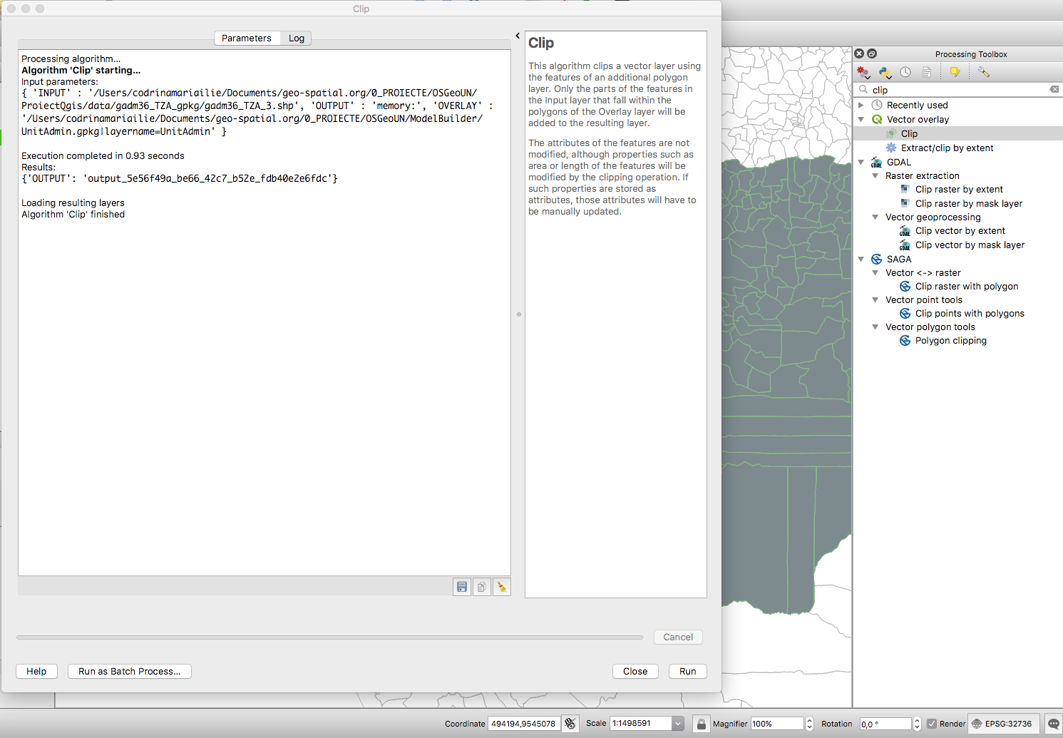
File:Fig2 clip.png Clip tool for vector data identified in the Processing Toolbox through search functionality.(1,491 × 1,035 (303 KB)) - 02:19, 21 January 2019- ...riented data model which provides for the integration of raster and vector data representations in a single environment. SPRING is a product of Brazil's Na #[[File:1_1_13 How to Begin Step 7 Visualize Cadastral Data.odt]]2 KB (265 words) - 14:20, 29 September 2012
- ...ch powers the [https://data.linz.govt.nz LINZ Data Service] and other open data portals. ...vily involved in the open data space in New Zealand, and have worked on NZ data imports and improvements into OpenStreetMap. Have attended and spoke at sev1 KB (184 words) - 00:05, 23 May 2020
- ...based on a human-readable text file format and can be used to exchange CAD data between different programs. We need to design and implement a DXF file pars ...initial work done on a catalog system that would allow this management of data sources to take place, but it has not been fully designed or implemented.4 KB (640 words) - 04:19, 15 March 2007
- ...GIS can be defined as an information system that is designed to work with data referenced by spatial or geographic coordinates ( more definitions). It see * promoting the use and release of publicly available geographic data in the same sense of freedom as for [[Free Software]],2 KB (249 words) - 14:05, 9 November 2007
- ...designing their own culturally appropriate ICT solutions using open source data and tools to address the challenges they face. ...enous FOSS4G Hackathon 2021 will help maximise the social benefits of open data3 KB (349 words) - 07:56, 15 September 2021
- ...on|existing free geodata]] for the community. This comprises re-packaging, data storage in convenient formats, tiling and other. * data are stored on geodata.telascience.org in /geodata/<user>5 KB (701 words) - 07:11, 27 April 2008
- ...Licensing Geographic Data and Services], Committee on Licensing Geographic Data and Services, National Research Council, EEUU. Puede descargarse en PDF de * [http://www.okfn.org/wiki/OpenDataLicensing Guide to Open Data Licensing], Open Knowledge Foundation.5 members (0 subcategories, 0 files) - 03:55, 5 April 2009
- [http://www.sdx.com.au Spatial Data eXchange Pty Ltd]182 bytes (29 words) - 14:10, 28 December 2006
- I'm working with GIS data and spatial databases for several years, espcially with OpenSource software101 bytes (15 words) - 03:36, 5 February 2016
- [[Category:Public Geospatial Data Committee]]151 bytes (17 words) - 11:27, 6 October 2007
- Ketty Adoch uses computers and geography data to solve environmental challenges in the community.97 bytes (14 words) - 08:07, 5 November 2018
- FOSS4G 2018 LOC, Open Data expert and activist, HPC lead / Senior Systems Analyst81 bytes (13 words) - 16:29, 15 March 2017
- ...rojects. He has every intention of contributing to the [[Public Geospatial Data Committee]].201 bytes (28 words) - 11:00, 12 October 2007
- Data editor of this solution is provided as another project, [https://github.com == Basic Project Data ==2 KB (240 words) - 00:15, 16 January 2019
- ...ex.php/Repository_of_modules#Web_GIS_data_resources:_US_and_global Web GIS data resources: US and global]=== ...ital_data An example of regional web resources: Massachusetts, USA digital data]===8 KB (1,038 words) - 11:36, 21 September 2007
- === Data Set === * Members may want to upload and create metadata about data sets as part of a project.2 KB (320 words) - 10:33, 12 June 2006
- * Writing about open data licensing for geodata [[Category:Public Geospatial Data Committee]]1 KB (159 words) - 08:34, 23 August 2007
- == EGU Data Help Desk 2021 == ...relevant OSGeo-related aspects, tasks, ressources and stakeholders for the Data Help Desk.1 KB (199 words) - 11:38, 13 November 2023
- === OpenStreetMap data import tool improvement === The recently contributed OpenStreetMap data import tool has a couple of limitations, such as supported attributes, memo2 KB (349 words) - 08:53, 6 April 2009
- /benchmarking/wms/2011/data/raster/DEM/bil_16int/data ...altindex dem_bil16int.shp /benchmarking/wms/2011/data/raster/DEM/bil_16int/data/*.bil</code>2 KB (239 words) - 04:15, 24 February 2015
- ...tware development, web mapping applications, spatial analysis, interactive data visualizations, website development, hosting and maintenance etc. His caree618 bytes (83 words) - 06:11, 28 August 2017
- :Manager – Spatial Data Infrastructure ...de free geodata. [http://www.snb.ca/geonb/ GeoNB - New Brunswick's Spatial Data Infrastructure<br>]{{#umSetParam: -66.64824|45.94034|Fredericton, NB, Canad1 KB (150 words) - 19:56, 29 June 2010
- [[Category:Public Geospatial Data Committee]]149 bytes (17 words) - 11:28, 6 October 2007
- [[Category:Public Geospatial Data Committee]]149 bytes (17 words) - 11:29, 6 October 2007
- I am interested in combining the practices of data science with software engineering and geospatial.100 bytes (15 words) - 17:40, 18 August 2017
- [[Category:Public Geospatial Data Committee]]157 bytes (18 words) - 12:13, 6 October 2007
- A recent college grad, I specialize in front-end web mapping and data wrangling.80 bytes (13 words) - 12:08, 10 August 2017
- ; 9.15 : DVD and Data ...ude instructions for submitting installers, instructions and tests, needed data or media, etc.1 KB (173 words) - 17:35, 19 August 2009
- -> I have developed spatial data warehouses using technologies such as Oracle Spatial and PostGres/PostGIS. -> I have built complex ETL routines to consolidate data from multiple sources and multiple formats into various destinations.996 bytes (156 words) - 05:24, 2 April 2015
- ...munity project: Open Data Cube Project https://www.osgeo.org/projects/open-data-cube/ Open Data Cube Project3 KB (382 words) - 08:49, 26 April 2024
- ...who works with optical and microwave remote sensing imagery, vector based data, and VGI from social media and OpenStreetMap. In the past eight years I hav579 bytes (89 words) - 15:52, 17 August 2017
- gvSIG Online is a solution for Spatial Data Infrastructure in open source software. With gvSIG Online a user will be ab It will allow to add a geoportal of gvSIG Online as a new data source, adding in gvSIG Desktop all the Web Map Services published in this3 KB (394 words) - 06:42, 27 March 2017
- Jacob Raymond - GIS Data Lead98 bytes (16 words) - 22:46, 9 January 2015
- Environmental engineer working in the field of hydraulic engineering, gis data elaboration and map creation107 bytes (15 words) - 02:19, 3 October 2016
- sudo chmod -R g+w /benchmarking/wms/2011/data/vector/osm_base_data/data/ rm /benchmarking/wms/2011/data/vector/osm_base_data/data/*index2 KB (298 words) - 04:15, 24 February 2015
- '''Part III. Data''' |Conceptual, representation and storage models for spatial data. || 44 KB (653 words) - 12:17, 31 October 2007
- • Spatial Data Modelling • Spatial Data Structure – Explicit Topology, Voronio, Delaunay Triangulation etc975 bytes (142 words) - 07:35, 21 October 2009
- ...application to view and edit the spatial information, and publish the live data to Google Earth, all on their own laptop. = Spatial Data Management System =2 KB (361 words) - 21:17, 6 May 2007
- ...OSGeo & friends comes from the task to synthesize radar beams from charts data.189 bytes (31 words) - 04:28, 7 April 2008
- ElecTech Solutions specialise in publishing real-time marine sensor data for the Shipping and Scientific industries.116 bytes (15 words) - 16:41, 15 March 2017
- ...upport and add support for richer information available through the Navteq data model. === Add Turn restriction support based on Navteq data model ===4 KB (582 words) - 19:17, 23 March 2010
- == Basic Project Data ==2 KB (219 words) - 18:55, 19 March 2016
- Engineer in Flood Risk Management Data Management Section, OPW, Ireland71 bytes (10 words) - 02:29, 15 December 2016
- Geo Data Geek ...en joined them and began a career in GIS. He spent 12 years at Esri as a Data Engineer with ArcGIS Online (aka ArcIMS, Geography Network, ArcData Online)2 KB (380 words) - 20:48, 21 August 2018
- #REDIRECT [[New Virtual Raster Data Provider for Raster Calculator in QGIS]]76 bytes (11 words) - 03:49, 18 August 2021
- |JobTitle=GIS Data Coordinator |Info=The GIS Data Coordinator at Angus Council. Organises QGIS UK user group meetings in Scot634 bytes (92 words) - 02:51, 14 October 2019
- I am a CAD technician currently working within a data communications semi-government entity.92 bytes (13 words) - 12:34, 23 October 2017
- ...d multi data, as well as provide thread safe asynchronous access to raster data.2 KB (243 words) - 11:22, 30 March 2009
- == Data Package Group == * Detail page [[Edu Data Package]]3 KB (390 words) - 17:38, 26 September 2007
- ..., data literacy, and open geospatial. He is the proprietor of BNHR—an open data and open geospatial consultancy in the Philippines—as well as the co-foun He supports and takes an active role in the open data and open geospatial communities in the Philippines both as an individual an2 KB (246 words) - 04:05, 28 November 2023
- '''Civic apps and State data''' - what data sets does the state have that would be interesting to app developers?3 KB (488 words) - 06:13, 18 November 2014
- ....telascience.org:8080/geonetwork/srv/en/main.home OSGeo GeoNetwork spatial data portal]243 bytes (28 words) - 07:36, 27 August 2007
- Spatial Planner involved in OpenStreetMap on #MapLesotho using opensource data to produce spatial planners.107 bytes (14 words) - 06:59, 31 August 2018
- ...s based on open data from OSM and NASA and was developed using open source data.508 bytes (92 words) - 09:52, 20 July 2018
- GO / Data mining Geomarketing Analyst Developer "The INSPIRE directive lays down a general framework for a Spatial Data Infrastructure (SDI) for the purposes of European Community environmental p978 bytes (135 words) - 02:29, 15 December 2016
- Open data and map enthusiastic. Especially old maps, for genealogy and history intere104 bytes (16 words) - 09:15, 18 March 2016
- Humanitarian Information Specialist & Data Engineer. GeoNode developer & fan of the Humanitarian OpenStreetMap Team (123 bytes (14 words) - 05:52, 15 August 2016
- Interests: Open source GIS, open data96 bytes (15 words) - 09:24, 6 August 2012
- RDTN.org maps radiation info from Japan and beyond, aggregating data from a number of sources. Soon to be a KML feed. ...e nor widely available on short notice, so they needed to find alternative data sources.3 KB (479 words) - 01:26, 18 October 2012
File:SSURGO to PostgreSQL.odt A method to import USDA-NRCS SSURGO soils data into PostgreSQL on a GNU/Linux OS.(37 KB) - 20:43, 13 October 2011- Pet topics are complex data models and schema transformation.98 bytes (15 words) - 02:44, 2 August 2016
- ...tralia, interested in social development and horticultural uses of spatial data121 bytes (16 words) - 23:19, 30 August 2019
- [[Category:Public Geospatial Data Committee]]308 bytes (46 words) - 08:33, 23 August 2007
- ...e and look for opportunities to contribute to it in the area of geospatial data management and access. .... John has promised to actively work on clarifying the issue of geospatial data licensing.5 KB (892 words) - 20:39, 20 May 2007
- ...rage in watershed systems at multiple spatial-temporal scales. She applies data from hydroclimate observations, geographic information systems, and remote ...roundwater interactions though the power of spatiotemporal data mining and data visualization.1 KB (143 words) - 16:22, 14 April 2019
- ...ases, including storage, publishing, viewing, analysis and manipulation of data. It also contains sample datasets and documentation. ...ta processing. The series of "interactive dashboards" will make use of the data already available on the OSGeo-Live as well as web-based resources, making2 KB (256 words) - 09:20, 20 February 2016
- ...u don't have any maps to put in it. Academic staff and students can access data through license agreements, but tend to be tied to whatever standard propri ...n, and a general increase in profile for open source software /open access data means that more people are aware that there is a choice, and are actually s2 KB (433 words) - 04:32, 24 February 2008
- == Public Geospatial Data Committee == The Public Geospatial Data Committee has been fairly dormant committee of OSGeo over the course of 2002 KB (283 words) - 09:45, 1 April 2009
- ...umanitarian causes. Interests in remote sensing, drones, AI, open data and data sharing.764 bytes (100 words) - 10:29, 11 March 2020
- ...e satellites will produce massive quantities of data, and therefore need a data platform that can meet the challenge. ...secure acquisition, storage, distribution, and access of Earth observation data, including hyperspectral and thermal infrared imagery.2 KB (311 words) - 03:23, 20 June 2023
- * Provide a working and complete (likely overly complete) spatial data infrastructure to conference participants. ...rs, workshop coordinator and lab coordinators will have a greater range of data and services to leverage.6 KB (900 words) - 20:21, 27 November 2008
- ...gentine Cartographic Center. Working in Open Data and the National Spatial Data Infrastructure to spread the word of FLOSS.761 bytes (99 words) - 13:15, 1 October 2021
- ...vailable in a large variety of formats as maps/images or actual geospatial data. GeoServer's transactional capabilities offer robust support for shared edi626 bytes (95 words) - 05:56, 8 November 2010
- ...ng interoperability and universal access, I contribute to a more efficient data environment, marking a significant stride in transformative geospatial solu773 bytes (98 words) - 19:55, 18 January 2024
- ...ng on the Join the OSGeo Community task.I like Geomatics technologies and data."112 bytes (19 words) - 04:45, 29 October 2018
- Geographer, data explorer, amateur photographer, avid traveler.124 bytes (18 words) - 00:25, 31 May 2016
- ...espatial data. ''Join the [http://lists.osgeo.org/mailman/listinfo/inspire-data INSPIRE Mailing list].''.6 members (0 subcategories, 0 files) - 09:39, 13 March 2013
- [[Category:Public Geospatial Data Committee]]194 bytes (24 words) - 12:17, 6 October 2007
- ...ynthetic Aperture RADAR) "Processor" using GDAL as a data reader/processed data writer ...(and potentially write new drivers) for reading new/common unprocessed SAR data sources, including metadata support where needed3 KB (387 words) - 01:55, 15 April 2008
- ...blown spatial data infrastructure implementations, and discussions of Open Data and Open Source policies.938 bytes (141 words) - 01:46, 13 November 2019
- ...and_tsunami/Mapping_coordination_and_data_sources#Where_to_map Mapping and Data Coordination] (best resource) ...n_OSM_Tags/Humanitarian_Data_Background Humanitarian OSM Tags/Humanitarian Data Background]1 KB (182 words) - 12:42, 1 April 2011
- *Allowing data and knowledge to bridge the gap between theory and practice320 bytes (40 words) - 03:10, 6 May 2008
- ...a masters degree on forest sciences who have been working with geospatial data since 2007. I started working on Brazil's Ministry of Environment on 2013 w ...blic and government agencies with their environmental demands with spatial data.707 bytes (112 words) - 16:27, 15 March 2017
- [[Category:Public Geospatial Data Committee]]194 bytes (24 words) - 11:24, 6 October 2007
- ...al models to track COVID-19 using Open Source tools such as Panoply, R and data such as SEDAC Gridded World Population. ...vice on tools and approaches for manipulating spatialized population count data for epidemic state variable layers ( ex: Susceptible, Infectious, Recovered3 KB (412 words) - 14:41, 7 May 2020
- ...on of decision support systems, standards and interoperability of research data. He is interested in various fields of open knowledge: free and open source1,012 bytes (145 words) - 05:59, 13 October 2020
- Dedicated to Decolonizing Data, Updating Historical Maps ...providing the software and equipment needed to gather, create and analyze data for the purposes of Cultural Conservancy and Tribal & Environmental Advocac643 bytes (67 words) - 10:22, 30 April 2024
- ...to help public administrations choose or design an open license for their data.'' ''It is inspired by the Open Knowledge Foundation's Guide to Open Data Licensing.''7 KB (1,038 words) - 06:03, 26 May 2009
- == Basic Project Data ==2 KB (225 words) - 03:57, 16 July 2016
- ...org) since 2014, living in Asheville NC, interested in open-source spatial data solutions.173 bytes (22 words) - 09:27, 13 May 2017
- ...sh National Mapping Authority]. Professional interests include point cloud data and coordinate system transformation (PROJ).239 bytes (31 words) - 00:09, 20 July 2018
- ==Edit your Data== Editing is similar to entering data..2 KB (384 words) - 19:28, 16 December 2020
- GIS Analyst at MassGIS, Former Data Analyst at Spatial Networks, UW-Madison Alum80 bytes (12 words) - 18:10, 18 August 2017
- ** New providers for GeoJSON data and Oslandia's [https://github.com/Oslandia/building-server building server ** Enable a hierarchical structure to display all of its data instead of only the leaves745 bytes (103 words) - 07:56, 19 February 2016
- ...OSM) is a project aimed squarely at creating and providing free geographic data such as street maps to anyone who wants them. The project was started becau ...h OSGeo's mission and add considerable momentum to the [[Public Geospatial Data Project]].2 KB (291 words) - 01:46, 25 January 2010
- ....opengeospatial.org open standards] and [http://www.openstreetmap.org open data].220 bytes (31 words) - 15:56, 11 January 2012
- ...essing and productizing massive quantities of data, or collecting airborne data internationally. Believes in the power of constructive disagreement, of fos758 bytes (106 words) - 09:44, 9 October 2018
- Natural Earth Data (http://www.naturalearthdata.com/)233 bytes (30 words) - 08:17, 16 January 2013
- ...cipated in local GIS-related conferences and meetings to advocate open geo-data, promote Open Source GIS and introduce OSGeo to Taiwanese GIS communities. * Open Data is the first and most urgent task on the list of priorities of OSGeo Taiwan2 KB (280 words) - 03:11, 14 February 2008
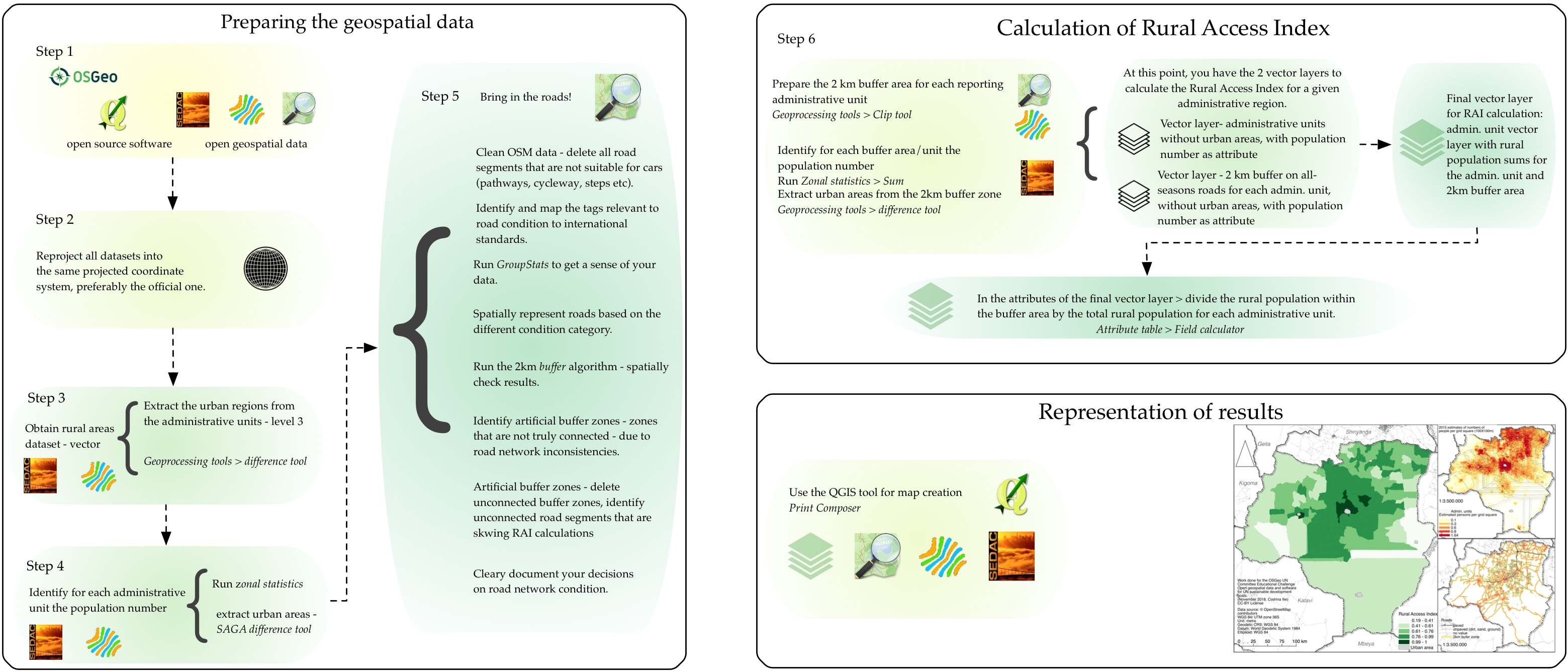
File:Fig25 workflow.jpg ...ual schema for the workflow to calculate the Rural Access Index using open data and open source software.(3,119 × 1,336 (805 KB)) - 03:33, 21 January 2019- [[Category:Public Geospatial Data Committee]]232 bytes (36 words) - 01:32, 30 March 2008
- ...e. The Geochicas initiative aims to bring more women to collaborate in the data creation of OpenStreetMap and promote more women participation and knowledg ...y players. Currently she is involved in Open Data, Autonomous vehicles and data analysis initiatives.2 KB (219 words) - 12:00, 10 October 2018
- ...tware, but for data, as well. In the absence of detailed and comprehensive data to work with, the utility of geospatial software becomes drastically reduce ...growth of commercial markets. The contrast in public access to geographic data between, for example, the United States and Europe, suggests that undue res4 KB (586 words) - 13:31, 14 November 2010
- ...e (GISc) and Computer Science; multi-dimensional geovisualization, spatial data infrastructure, open source for geospatial software and geoinformation stan ...ove less fortunate communities, and has also been involved in various open data events in South Africa.1 KB (166 words) - 01:13, 29 December 2020
- *** they want to make at least one (better two) topic talks on "Open Data and Collaborative Mapping - Bridging the application - developer divide" ** Copernikus as European Satellite program - Open Data4 KB (617 words) - 03:48, 10 January 2016
- ...ta Package Group | Public Geospatial Data]] [2] by the [[Public Geospatial Data Committee]] ...Groups#Goal_2 | Online tutorials]], and disseminate and presentat spatial data and software4 KB (607 words) - 05:51, 8 September 2006
- ...ng JSON output support to Grass GIS. Also, pursuing a Bachelor's degree in Data Science.136 bytes (21 words) - 01:27, 17 May 2024
- Researcher and project manager in Spatial Data Infrastructures, e-government, interoperability and public participation (S195 bytes (22 words) - 09:18, 8 March 2016
- Research Interests: spatiotemporal databases, scalable spatiotemporal data systems, high performance computing.242 bytes (29 words) - 07:51, 7 February 2017
- =[[KPI's and AWStats data]]=308 bytes (44 words) - 01:47, 21 February 2008
- ...s in data management in EU, Africa and Asia. My research interests include data analysis, sensor web, open source technology and architectures for knowledg1 KB (166 words) - 08:11, 9 October 2018


