Annual Report 2007 Compiled
Executive Reports
OSGeo in 2007
Welcome to the first edition of the OSGeo Annual Report -- a lot happened in 2007 and this document brings together highlights from across the spectrum of OSGeo activities. Nearly 50 reports from dozens of different authors and communities were contributed.
OSGeo has continued to grow, here are a few statistics to help show the magnitude of development during last year.
- 1st OSGeo branded FOSS4G conference hosted 720+ attendees
- 3 new volumes of the OSGeo Journal, 44 articles and over 70 contributors
- 5 new projects entered incubation (14 total)
- 6 Local Chapters were officially approved (9 in total) and a total 20+ Local Chapters have been started
- 7 initial Foundation Sponsors
- ~\$160,000 in sponsorship collected
- 100+ mailing lists, 13,300+ subscribers
- 6,000,000+ lines of code, representing 1,400+ years of effort across all projects
- Dozens of presentations, workshops and events around the world!
- Web site statistics (May-Dec, no robots/worm traffic reported):
- 147,000 unique visitors (54\% increase),
- 284,000 visits (51\% increase),
- 1,502,508 pages (46\% increase),
- 7,588,049 hits (80\% increase),
- 140.71GB bandwidth
- Portions of website translated into 13 different languages
Throughout the following reports you will learn more about the projects and teams that made all this happen. It has been an incredible year to watch and a great challenge to keep up with all that has developed.
This is also your invitation to join in. You will find that many of the reports identify specific areas where you can help. Links to all our projects and their mailing lists are available on the main OSGeo.org website.
I hope you enjoy the articles and I look forward to this report next year as we continue to sail through the exciting and uncharted open source geospatial world.
Sincerely, Tyler
[NOTE: The next edition of the OSGeo Journal will be back to normal, including Case Studies, Project Introductions and more.
Board of Directors Report 2007
January
- ILWIS GIS Software Migrates to Open Source
- MapGuide Open Source 1.1.0 Released
- FOSS4G in Victoria, Canada, September 24-27, 2007
- GDAL/OGR 1.4.0 Released
- GeoTools 2.3.0 Released
February
- OSGeo Celebrates 1st Anniversary
- FOSS4G 2007 Call for Workshops Reminder
- OpenLayers 2.3 Released
- MapServer 4.10.1 Released
- MOSS4G Project Announcement
- FOSS4G 2007 Call for Workshops
March
- OSGeo Accepted for Google Summer of Code
- MapGuide Open Source helps San Francisco protect the urban forest
- QGIS and FDO Enter OSGeo Incubation
- MapGuide Open Source Graduates Incubation
April
- deegree day 2007 – Call for Papers
- OSGeo Welcomes Sixteen Students for Google Summer of Code
- FOSS4G 2007 Call for Presentations
May
- AWare Systems to extend LibTiff library with support for the new BigTIFF format
- OSGeo Journal Volume 1 Now Available
- Seeking Consultants and Service Organizations
June
- GDAL/OGR 1.4.2 Released
- FOSS4G 2007 Call for Presentations Closes THIS WEEK
- Quantum GIS 0.8.1 Released
- Journal Submissions for Peer Review
July
- FOSS4G 2007 Early Bird Registration Ends FRIDAY
- GRASS GIS releases version 6.2.2
August
- Ominiverdi Desktop LiveCD 2007.1 Released
- FOSS4G Program Finalized - 1 month to go!
- Sol Katz Award for Geospatial Free and Open Source Software - Call for Nominations
- FOSS4G 2008 Awarded to Cape Town, South Africa
- OSGeo Board Election Results
September
- Steve Lime Wins Sol Katz GFOSS Award
- MapServer 5.0 Released
- OSGeo Journal Volume 2 Available
- OSGeo Annual Meeting at FOSS4G
- gvSIG Enters OSGeo Incubation
- MapGuide Open Source 1.2.0 Released
October
- OSGeo Announces Request for Proposal for Hosting 2009 Conference
- Mapbender 2.4.3 Released
November
- Italian Local Chapter Formed
- OpenLayers Graduates Incubation
- GEOS Enters OSGeo Incubation
- Francophone Local Chapter Formed
December
- GDAL/OGR 1.5.0 Released
- FOSS4G Proceedings - Journal Vol. 3 Now Available
- GRASS Book 3rd Edition Available
DRAFT financial statements for 2007 year-end are located here. These are not passed and approved by the Finance Committee yet.
THE FOLLOWING IS A WORK IN PROGRESS AND NOT COMPLETE
The narrative for the Financial Report section, from the Finance Committee, is under development
OSGeo's first full financial was in 2007. While there were some funds to manage in 2006, the sponsorships and other costs really started moving at the end of the year and into 2007.
Highlights from 2007
- Dave McIlhagga was appointed Treasurer for OSGeo.
- The Board created a Finance Committee to oversee financial activities. The group consists of: Dave McIlhagga, Jo Walsh, Paul Ramsey, Ken Tamura, Tyler Mitchell. The group uses a public mailing list for most of its discussion. (See http://lists.osgeo.org/mailman/listinfo/finance)
Sponsorship & Revenue
There were officially seven sponsors during 2007. Three of whom donated at the end of 2006 but four additional ones who joined throughout the 2007 calendar year. Sponsorship positions have a 1 year term and all 2006 sponsors renewed their support for another year.
- $130,000 was from Autodesk as a special donation, giving them a Sustaining Sponsorship position
- $20,000 came from the Supporting Sponsors: INPE and Ingres
- $12,000 came from the Associate Sponsors: 1Spatial, First Base Solutions, LizardTech, WhereGroup
There was also significant revenue generated from annual Project Sponsorships through GDAL/OGR.
Our first year of fundraising was a success and helped sustain and surpass our financial needs for the year. Additional sponsors for the following year are already starting to come forward so our program can be extended.
More than $100,000 was raised from the FOSS4G 2007 annual event.
2007 Reports
Past Reports
THE ABOVE IS A WORK IN PROGRESS AND NOT COMPLETE
Committee Reports
OSGeo Education and Curriculum Committee
- Period covered by report: Jan-Dec 2007
- Contact name: Charlie Schweik
Key Accomplishments
At the edu BOF meeting at FOSS4G 2007 we had 30 people in attendence. We held a second BOF where we did a "Wiki Sprint" to revise the group's web presence on the OSGeo website. At these meetings and subsequent group email discussions afterward, we came up with four major tasks for the 2007-08 year until the next FOSS4G meeting. We maintain this list at: http://wiki.osgeo.org/index.php/Education_Committee_Work_Program. We are developing: (1) an inventory of existing and new educational material; (2) suggested authoring methods, content management system, and a distribution and search facility; (3) a FreeGIS book; and (4) a multi-language OSGeo dictionary. Some hightlights from these efforts to date include:
- Educational Material (some highlights)
- 20 courses or sets of tutorials were inventoried immediately after FOSS4G 2007. See http://wiki.osgeo.org/index.php/Educational_Content_Inventory.
- Markus Neteler and Helena Helena Mitasova published a third edition of Open Source GIS: A GRASS GIS Approach (2008). See www.grassbook.org. In addition, a freely available data set for use with the book but also any other other course or tutorial is available at http://www.grassbook.org/data_menu3rd.php.
- Discussions regarding authoring methods, content management, distribution and search facility have been on-going. Our current thinking based on group dialog:
- Authoring methods: DocBook was proposed. While there was some support, there also was some concerns about (1) learning curve for new authors; (2) The lack of a FOSS GUI editor for DocBook; and (3) The steps involved in converting DocBook to other formats like PDF. The discussions showed that some in the group who have significant material are using LaTeX. Scribus has also been suggested. We've now concluded that the effort in 2008 needs to be open to a variety of authoring methods, but Docbook, LaTex (Lyx) and Scribus may be three that we recommend.
- Content Management/Version Control. The OSGeo Foundation has created a Subversion repository for our use. This will be a storage facility where people can add documents and check “development versions” out for editing. A small committee is in the process of setting the system up and testing it out with the goal of developing a short tutorial to guide our authors. There will be designated “owners” or “maintainers” of educational content. This, we hope, will support building the capability for “new derivative work” based on previous content.
- Distribution of “Production” content: We will try and utilize the OSGeo Wiki to distribute "major" versions of educational content. The idea is when a document is ready for distribution to the masses, it gets converted to pdf format and posted to the Wiki.
- Search facility. A still open issue is building an adequate search search facility of educational material. Our inventory wiki page is getting very long already and currently there is no easy way to query for educational material (e.g., show me all the content that is related to GRASS). One important point we seem to be in agreement on is that we want to store educational material by “module” and associated course, but not just by course. This will allow future users to be able to “pick and choose” content from a variety of sources. In 2007 we investigated potential options with “module” capability, including Rice Connexions repository. But currently group members have suggested to try out the OSGeo wiki for this purpose, using “category tags.” Landon Blake offered to write a simple desktop GUI that could be used to search for OSGeo educational content. In 2008 we will be continuing to work on this, starting with the idea of using the wiki.
- FreeGIS book
- Víctor Olaya Ferrero, Universidad de Extremadura, Spain has been providing leadership in this edu sub-project.
- The table of contents has been fully defined, and each chapter has at least a main author, which is responsible of it.
- A first meeting of authors was held in Valencia in November. A date (March 4th, 2008) has been set for a new meeting, and a list of main issues to discuss has been defined.
- So far, more than 430 pages have already been written. All the chapters have at least a brief introduction and a list of keypoints, so authors of others chapters can know its content and take it into account when writing their own ones.
- One model that is beginning to emerge is the idea of writing articles for the OSGeo Journal that then will be added as chapters to this book. Currently Landon Blake has written a rough draft of Geospatial Metadata chapter intending to follow this model of production.
- Multilanguage Dictionary
- Work on the OSGeo Multilanguage Dictionary project has really just started and Landon Blake has agreed to lead this subcommittee. Several team members are planing on adding definitions to the dictionary based on their current work ().
- OSGeo Edu and general marketing
- Puneet Kishor (University of Wisconsin, Madison) has, over the last year, been involved in several major events where he has been promoting OSGeo edu's (and OSGeo in general) activities, including: The Science Commons Open Access Data Meeting; The US National Academies at the workshop on "Information Commons for Science"; The Brazilian workshop "Strategies for Permanent and Open Access to Scientific Data"; UNESCO Paris meeting on "Common Use Licensing of Scientific Data; Specialists Meeting on Volunteered Geographic Information" at Santa Barbara.
Areas for Improvement
- We continue to think that there are probably opportunities connecting the Edu activities with the OSGeo projects and that we do not have an adequate inventory of educational material available in these projects. It might be helpful to have a designated person from each project be represented and active on this committee.
- There appears to be some interest to develop develop a packaged cd for Ubuntu to launch at Foss4g2008. This seems to cross several OSGeo committees and we haven't been able to get this mobilized. We have heard that there may be some efforts already underway (perhaps by groups outside of OSGeo) toward this end.
Opportunities to Help
- First, we can always use help on any one of the major activities listed above. In addition, more specifically, we could use help on:
- INVENTORYING TRAINING MATERIAL NOT YET LISTED. We are pretty sure that other OSGeo-related projects have tutorials or educational material that we have not inventoried. We encourage other OSGeo participants (and others outside of OSGeo) to add their components to our Educational_Content_Inventory page. If someone would step up to take the lead in contacting each OSGeo project and ask them about relevant educational material we could list or point to, and to encourgage them to list any future material on our intentory page, that would be a great help.
- TRANSLATIONS. In all of our existing documentation, we could use people to either translate existing tutorials into other languages other than English or by contributing new educational content, or new dictionary terms and definitions. And there is a sizable (400+ pages) written for the FreeGIS book written in Spanish, that we could use translations done into English.
- DEVELOPING NEW EDUCATIONAL MATERIAL. If you are interested, please add an entry to our Commitments_for_New_Material_Development page.
- DEVELOPING A SEARCH MECHANSIM. Currently, all our tutorials are listed in the wiki and typically linked to outside sources. As this list grows, we think we need better methods of finding relevant material for end users.
- DEVELOPING THE PROCESS/SYSTEM FOR NEW DERIVATIVE WORKS. Ultimately, we are working toward a system where people can utilize and download training material and update it where deemed necessary. We haven't yet had that situation happen, but we are getting close. If someone reading this is interested in utilizing someone else's existing content listed on our Educational_Content_Inventory page, and wants to create a new derivative of the content, please contact the author of the content and copy the chair of the edu committee (Charlie Schweik ar cschweik AT pubpol DOT umass DOT edu).
Outlook for 2008
Our primary goals for the next FOSS4G conference is to have, in place:
- An initial set of educational material with “designated maintainers” that is open access and, at least in some instances, allows for new derivatives (Educational Content Inventory);
- A working content versioning system (probably Subversion-based);
- A system for searching educational material that will allow, as new material is added, users to find tutorial “modules” or complete courses, relatively easily;
- Recommended authoring tools that are easy to use and help us move forward in developing a library of educational material. We intend to accept material in any digital form, but our hope is we can develop some easy standards that will enhance the searchability of the tutorials as our library grows.
- Continued efforts on the Free GIS Book and OSGeo Multilanguage Dictionary;
- New educational material. Several OSGeo edu members are developing new teaching material and have made informal commitments to make some or all content available through the OSGeo educational collaborative.
- These are (in no particular order):
- Advanced Topics in Geographic Information Systems (Scott Mitchell, Carlton U., Canada. Language: English)
- QGIS and GRASS orientation workshop (Scott Mitchell, Carlton U., Canada. Language: English)
- Exploring and interpolating fields (Maria Antonia Brovelli, Polytechnic of Milan and Polytecnic of Zurichand and Markus Neteler, Centre for Alpine Ecology, Italy. Language: English)
- Training Notes on Spatial Data Sharing using FOSS 2008 (Venkatesh Raghavan, Osaka City University, Japan and colleagues Shinji Masumoto, Sarawut Ninsawat, Daisuke Yoshida, Susumu Nonogaki, Willington Siabato. Language: not specified)
- E-course on FOSS GIS (Moritz Lennert, Free University of Brussels, Belgium. Language: French)
- Geospatial Analysis, Modeling and Visualization (title may change). (Helena Mitasova, North Carolina State University, USA. Language: English.)
- Introduction to Remote Sensing using FOSS (set of modules). (Ned Horning, American Museum of Natural History, USA, and Maili Page and Charlie Schweik, University of Massachusetts, Amherst, USA)
More detail on these efforts are listed at http://wiki.osgeo.org/index.php/Commitments_for_New_Material_Development.
In addition, members will continue to market our edu efforts and OSGeo in general. One member, Puneet Kishor will be giving lectures at a data and management workshop in Panama City organized by the Inter-American Institute for Global Change Research (IAI) and CATHALAC, and then later in spring I will be presenting a paper at AAAS. In both events he intends to underscore the need for open geospatial data and education information
Public Geospatial Data Committee
- Period covered by report: Jan-Dec 2007
- Contact name: David Bitner
Key Accomplishments
- Presentations and BOF at FOSS4G2007
- Support of Open Street Map, Open Aerial Map, and the Flight Gear Scenery Project
- Support of pulling together imagery during San Diego fires
- First OSGeo Educational data set available
Areas for Improvement
- Clear mission and direction that make it clear to members and outsiders who we are and what we do
- Work with others with similar goals so as not to reinvent the wheel
- Partner with those who need support of our resources
- Work more closely with Education Committee and education datasets
- Define clear areas where volunteers can be engaged
Opportunities to Help
- Strategic Planning -- without clear direction, it is hard to know where we can put peoples efforts to work
- Cataloguing work - both on software setup side (GeoNetwork) and collecting metadata for public data sets
- Open Geodata Licensing success stories - writing about how your organisation or project has moved to an open licensing approach, sharing decisions with others
Outlook for 2008
- Revised Mission
- Clear Directions
- Well defined areas where volunteers can get engaged
- A "GeoPortal" to data running on OSGeo systems
Incubation Committee
- Period covered by report: Jan-Dec 2007
- Contact name: Frank Warmerdam
- Members: Frank Warmerdam (chair), Chris Holmes, Robert Bray, Mark Lucas, Cameron Shorter, Steve Lime, Arnulf Christl, Jody Garnett, Markus Neteler, Paul Spencer, Richard Gould, Norman Vine, Daniel Morissette, Howard Butler, Jeroen Ticheler, Julien-Samuel Lacroix
Key Accomplishments
The following projects entered incubation in 2007:
- gvSIG
- FDO
- QGIS
- GeoNetwork
- GEOS
The following projects graduated from incubation in 2007:
The following project applications for incubation are pending:
- GeoMOOSE
- ORCHESTRA
- deegree
- JVNMobileGIS
This year we approved the Project Graduation Checklist.
Work Areas
The committee struggled with several issues this year, and will continue to work on them:
- What degree of professional legal support should be bringing to the incubation process?
- What key qualities do we look for in new projects?
- Is incubation suitable for geodata projects or other kinds of projects that do not meet our normal software project expectations?
- What support should be be providing to new projects just getting established?
- How much should a mentor be doing to encourage a project in the incubation process?
- Should we providing more resources, or applying additional pressure to projects that appear stalled in incubation?
Outlook for 2008
There are several projects that appear close to graduation and we see continued interest by new projects in joining OSGeo through the incubation process.
Journal
The Official Publication of OSGeo
- Period covered by report: Jan-Dec 2007
- Contact Name: Tyler Mitchell, Editor-in-chief
A New Work
In late February, 2007, the OSGeo Journal was born. In total, 3 volumes of the Journal were published in 2007. The purpose of this new project was threefold but has continued to morph into much more:
- Present News items from across the OSGeo community
- Collect Case Studies showing the application of OSGeo-related (and other) technologies
- Introduce readers to projects, local chapters and other works in OSGeo
Key Accomplishments
This first year of the OSGeo Journal was an exploratory pilot to gauge several things. The results were highly successful, here are a few of the highlights.
Making it Real
Initially we weren’t sure how much interest there would be in reading or writing for the Journal. The concept had been tested before under the GRASS News effort. Once we started collecting articles for the first volume, we had no problem seeing that a second volume would be easy to collect content for. The third held the FOSS4G conference proceedings and this report you are reading now, is the fourth. Interest continues to grow at a pace slightly faster than we can currently meet. This is encouraging and shows great opportunities for the future.
Interest Growing
After publishing the first three volumes of the Journal, interest began to grow considerably. There has also been added interest from the academic community looking for a place to published papers that fit the goals of the Journal. This is seen as an important accomplishment because there are really no other venues of this sort available to academic authors.
Team Growing
Our team has also continued to grow. Since starting up with only a few editors, we now have more than 10 people helping in different capacities as editors, plus several others who are available to help as reviewers. We also have an editor/manager overseeing the upcoming peer review processes.
Language Translation
The Francophone Local Chapter has done a tremen- dous job translating the Journal from English into French. This is not a simple affair and was done very efficiently. It is a great compliment to have this local chapter believe enough in the value of the publica- tion to see the worth in doing this work. Thank you to the group for taking this on. We continue to try to improve the process of Journal production so that the translation can be done easily. Other language groups are always welcome to join in.
Areas for Improvement
There are several areas were we are trying to im- prove:
- Streamline the process using the Open Journal System (OJS).
- Involving more editors and reviewers.
- Providing peer review opportunities.
- Improving layout and design for more attractive printing.
- Spreading the word about the Journal.
Opportunities to Help
You are welcome to help with any of the above areas, in particular we need help running and maintaining the OJS instance, so it can become the primary portal for the Journal. Also, the production has been funnelled, largely, through a few individuals. Opening up the process for others to help is important for the long term sustainability of the project. Editors, designers, reviewers and authors are all welcome to join. Please introduce yourself on our mailing list to show your interest.
- Period covered by report: Jan-Dec 2007
- Contact name: Arnulf Christl
Key Accomplishments
- Revive and then rename "Visibility and Promotion" to "Marketing"
- Refocus marketing strategy
- Help organize several events
- Help create and produce info material
- GeoConnexion Column thanks to Michael Gerlek
- Get Service Provider Directory under way
- Start and maintain list of Advocacy related pages
Areas for Improvement
- Grow team!
- Better maintain the Events Category
- Request for and then spend money for focused activities
- Spawn and nurse local initiatives
- Maybe focus more on attracting sponsors?
Opportunities to Help
- Join the Marketing Mailing List to stay up to date on what is happening
- Create brochures, information material and content for the Library
- Promote OSGeo by linking to our portal page and this Wiki
- Join the local organizing committee. Don't have one? Create it! Don't know how to? Ask the Marketing Mailing List.
- Translate portal page and information material
- Join regular IRC meetings
- Add events to the Wiki. Don't know how to? Ask the Marketing Mailing List.
Outlook for 2008
- Updated Logo for graduated projects and sponsors
- More appearances at events
- Create high quality brochure (under way)
- Create communication concept for further planning of focused activities (under way)
- Contact service providers individually to join directory and appear as sponsor
Systems Administration Committee
- Period covered by report: Jan-Dec 2007
- Contact name: Howard Butler
- Members: Howard Butler (chair), Norman Vine, John Graham, Gary Sherman, Daniel Morissette, Martin Spott, Wolf Bergenheim, Frank Warmerdam, Shawn Barnes, Who did I forget?
Key Accomplishments
- Completely migrated away from CollabNet and implemented our own infrastructure, which is hosted at Peer1.
- Implemented LDAP, Trac, Subversion, Mediawiki, Mailman, Drupal, Buildbot, download server, Subversion mirror, ...
Work Areas
- Remove the wildcard DNS entry for *.osgeo.org, which greatly complicates and limits our infrastructure maintenance.
- Continue migrating member projects who wish to have critical infrastructure bits like Subversion and Trac be hosted by OSGeo.
- Continue towards single sign-on goal (we have Trac, Subversion and Drupal running off LDAP, need Mediawiki, blade logins?)
- Keep the lights on...
Outlook for 2008
OSGeo WebSite Committee
- Period covered by report: Jan-Dec 2007
- Contact name: Your Name
Key Accomplishments
- the top 5-10 key items that the project or PSC accomplished this period
- Drupal Updated (Wolf)
- Layout Updated (many)
- Many modules added: Calendar, SPD, ecc.
- Multiple translations ongoing
- ...
Areas for Improvement
- any weaknesses in process, software, management, etc. that you plan to address or recognise need some help
Opportunities to Help
- list areas that could use some help from members and readers of the report
Outlook for 2008
- this is the motivational part that is meant to inspire readers to keep their eyes open for great stuff in 2008 :)
- Going on with translations
- Optimize News and Spotlight publication
- ...
Software Project Reports
FDO (Feature Data Objects)
- Period covered by report: Jan-Dec 2007
- Contact name: Greg Boone
Key Accomplishments
The following 4 releases of FDO were made available in 2007:
- FDO Open Source 3.2.1 Released - March 2007
- Bug fixes from 3.2.0 release
- The complete roadmap and features of FDO 3.2.2 can be found here: http://trac.osgeo.org/fdo/milestone/3.2.1.
- FDO Open Source 3.2.2 Released - July 2007
- Improved reverse engineering of views in MySQL and ODBC
- Upgraded filter support for Upper, Lower, Floor and Ceil functions in SDF
- Enhanced Bounds support for GDAL Provider configuration files
- FDO Provider Support for ArcSDE 9.2
- Addition of the FDO KingOracle Provider
- The complete roadmap and features of FDO 3.2.2 can be found here: http://trac.osgeo.org/fdo/milestone/3.2.2.
- FDO Open Source 3.2.3 Released - August 2007
- Bug fixes from 3.2.2 release
- The complete roadmap and features of FDO 3.2.3 can be found here: http://trac.osgeo.org/fdo/milestone/3.2.3.
- FDO Open Source 3.3.0 Beta 1 Released - December 2007
- Addition of the FDO Expression Engine
- Addition of the PostGIS Provider
- Continued development and release of the KingOracle Provider
- Alpha Release of the SQL Server Spatial Provider
- The complete roadmap and features of FDO 3.3.0 can be found here: http://trac.osgeo.org/fdo/milestone/3.3.0.
FDO adoption into Third Party applications continued in 2007:
- 1Spatial Radius Studio v1.4: 3.2.0
- Safe Software FME® 2007: 3.2.1
- Autodesk Map 3D 2008: 3.2.1
- Autodesk MapGuide Enterprise 2008: 3.2.2
- MapGuide Open Source 1.2.0: 3.2.3
- A list of products using FDO can be found here
External Vendor Adoption of FDO:
- FME® FDO Provider for AutoCAD® Map 3D 2008
Areas for Improvement
- Implement a formalized release process.
- While community contribution to the project is growing, most of those contributions are still on the periphery of the project. The core development on the API is still primarily fueled by developers at Autodesk. The project needs developers from the community actively working on some of the core components.
- Getting started with FDO and the process of building new providers are still more difficult than they need to be. Enhanced documentation, tutorials and certification tools would go a long way to improving this experience.
- A public build system for FDO would provide the community information on the state of trunk and access to daily builds of trunk.
- Linux based builds of FDO remain more difficult than they should be. Additional work is required to the build system of FDO to make it fully FGS viable.
- The PostGIS, King Oracle and SQL Server Spatial providers would really benefit from increased community development and support.
Opportunities to Help
All contributions and help is welcome, but in particular:
- Develop a new FDO provider for your currently unsupported format
- Help work on the PostGIS, KingOracle and SQL Server Spatial Providers
- Refine the website navigation and site structure.
- Develop and refine help and documentation, in particular a getting started tutorial.
- Enhance the Linux build system and complete the FGS package work.
- Testing and quality bug reports.
Outlook for 2008
2007 was a gret year for the FDO project. Considerable momentum has grown around the development community. The community hopes to keep this momentum going in 2008. Community contribution continues to grow at a steady pace, and we believe the 3.3.0 release will spark even more enthusiasm and collaboration. Finally with a little effort and support we believe the number of external developers contributing to the core code base will start to increase.
Expected Major 2008 Milestones:
- Graduate OSGeo Incubation: Febuary 2008
- Final Release of FDO 3.3.0: March 2008
- Final Release of SQL Server Spatial Provider for 3.3.0 and 3.2.3
- Continued enhacements to the feature set of the PostGIS Provider
- Continued development towards a service pack release of FDO 3.3.1 and beyond
- Continued development of new Data Providers for FDO
- Enahcements to the FDO API as discussed on the FDO Futures Discussion Page
GDAL/OGR report external at http://trac.osgeo.org/gdal/wiki/AnnualReport2007
GRASS Project Steering Committee 2007 Annual Report
This report is a summary of activities undertaken by the GRASS-PSC. It is expected that portions of this document will be included in the OSGeo Annual Report, and this document is not meant to be entirely inclusive.
Report Period
- This report covers the period of November 1st, 2006 until December 31st, 2007.
- Contact name: Markus Neteler
- PSC Members: Michael Barton, Dylan Beaudette, Hamish Bowman, Massimiliano Cannata, Brad Douglas, Paul Kelly, Helena Mitasova, Scott Mitchell, Markus Neteler, Maciej Sieczka
Formation Motion
The GRASS-PSC was formally convened on September 11, 2006, with Markus Neteler being appointed chair. David Sampson is acknowledged for pushing on the formation of the GRASS-PSC. Guidelines for the operation of the PSC and its formal connection to the GRASS project were extensively discussed for a number of months and formally adopted on 6 April 2007.
2006 Activities
- 20 Dec 2006: GRASS GIS / OSGeo Newsletter Published - The first combined GRASS-News / OSGeo-News volume is available
- 12 Dec 2006: GRASS 6.2.1 released - This release fixes several bugs discovered in the 6.2.0 source code
- GRASS-PSC: CVS write access to S. Pallecchi (granted, 12 Dec 2006)
- GRASS-PSC: PSC Chair motion (chair: M Neteler, 9 Dec 2006, see related email message)
- GRASS-PSC: CVS write access to R. Antolin (granted, 8 Dec 2006)
- RFC 2: Legal aspects of code contributions (adopted 8 Dec 2006)
- 06 Dec 2006: GRASS 6.2.1RC1 released - This release fixes several bugs discovered in the 6.2.0 source code
- 31 Oct 2006: GRASS 6.2.0 released - The stable version is published: Source code available now, packaged installers for major platforms are currently being built and will follow shortly
- 24 Oct 2006: GRASS 6.2.0RC3 released - The last release candidate
- 06 Oct 2006: GRASS 6.2.0RC2 released - Approaching the final release
- 26 Sep 2006: GRASS 6.2.0RC1 released - The first release candidate
- 18 Sep 2006: GRASS 6.2.0beta3 released - The last beta version
Early to Mid 2007 Activities
- Summer: participation in Google Summer of Code 2007 (Under the OSGeo umbrella) with two projects (now in the main release)
- GRASS-PSC: CVS write access to P. Marcondes for PT translations (granted, 2 June 2007)
- 26 Jul 2007: GRASS 5.4.1 released - Courtesy release containing several bug fixes for legacy users
- 16 Jul 2007: GRASS 6.2.2 released - This release fixes several bugs discovered in the 6.2.1 source code
- 29 May 2007: GRASS 6.2.2RC1 released - Bugfix release candidate
- RFC 1: Project Steering Committee Guidelines (extensively discussed and adopted 6 April 2007)
- Italian GRASS and GFOSS Users Meeting - GRASS and GFOSS Users Meeting, Palermo (Italy), 14-16 Feb 2007
- 12 Feb 2007: New GRASS bug and wish tracker - Gforge based
- 10 Feb 2007: GRASS GIS 6.2.1 winGRASS/Cygwin binaries available - download package
Mid to Late 2007 Activities
- OSGeo "incubation" process (GRASS Incubation Progress): almost completed, waiting for mentors approval to reach graduation
- Migration to OSGeo source code and bug tracker infrastructure (after many years successful hosting by Intevation GmbH)
- 30 Nov 2007: GRASS 6.3.0RC3 released - Technology preview release candidate 3
- 27 Nov 2007: GRASS 6.2.3 released - This release fixes several bugs discovered in the 6.2.2 source code
- 20 Nov 2007: GRASS 6.3.0RC2 released - Technology preview release candidate 2
- 24 Oct 2007: GRASS 6.3.0RC1 released - Technology preview release candidate
- 21 Oct 2007: GRASS 6.2.3RC1 released - Bugfix release candidate
- 24-27 Sep 2007: progress report, workshop and several talks presented at FOSS4G2007
- 19 Sep 2007: OSGeo Journal Volume 2 Published - The second volume of the new Journal
- 15 Aug 2007: test version of a new data set (Spearfish replacement) released
User statistics
- End of 2007, more than 4000 subscribers were counted in the various GRASS mailing lists.

Future strategy
Establish GRASS as GIS backbone, especially for other OSGeo projects.
GeoNetwork opensource
- Period covered by report: Jan-Dec 2007
- Contact name: Jeroen Ticheler and Francois Prunayre
Key Accomplishments
We made progress on incubation during the year 2007 and the following release of GeoNetwork opensource was made available in 2007:
- GeoNetwork opensource 2.1 (September 2007)
- New user interface based on Ajax and including Intermap as a web map client
- New harvesting mechanism (supporting WebDav, OAI-PMH, Z39.50, CSW)
- Support for opensearch client
- Bug fixes from 2.0
Events:
- Lab at FOSS4G2007 (September 2007)
- GeoNetwork opensource workshop in Roma/FAO (November 2007)
- User workshop
- Define principles to pass the OSGeo Incubation process
- PSC election
GeoNetwork opensource community website and trac moved to OSGeo infrastructure
Many, many new participants:
- 200+ subscribers to developers list
- 300+ subscribers to users list
Outlook for 2008
- OSGeo Incubation process
- Improve documentation (migration to DocBook)
- Create synergies with other SDI components (e.g. GeoServer, Talend Spatial Data Integrator, ArcCatalog)
- Improve modularity and work on new user interface to be embedded in existing website
The GEOS project is pleased to have been accepted into incubation! Find all details on the GEOS Incubation Status Wiki Page. At FOSS4G 2007, members of the GEOS community met, and decided to move the project under the OSGeo umbrella. Since then, the bug tracking and code repositories have been moved to OSGeo, and we are moving into the next stages of incubation: selecting a project steering committee, establishing the ground rules for decision making, and reviewing the GEOS code base for intellectual property issues. GEOS should be a great addition to OSGeo, with lots of strong corporate support and wide use throughout the geospatial software ecosystem!
Project Name
- Period covered by report: Jan-Dec 2007
- Contact name: [User:Jive]
Key Accomplishments
- An amazing amount of software at FOSS4G was built around the GeoTools library; we were very happy with the community presence at this event
- We had a 3 day long code sprint after FOSS4G in which we switched over to Java 5 an the GeoAPI feature model. This is the end of a three years of development, months of careful planning and review prior to the even allowed this change to go smoothly.
- Adrian Custer performed an exhaustive check into what is needed to assign copyright to the OSGeo Foundation, this has allowed us to resume discussions with the OSGeo board.
- Jody Garnett has started putting together a user guide for the library
- The introduction of an unsupported directly has revitalized the community; allowing us to capture and share a lot of research work traditionally has been done around the GeoTools library. As an example Eclisia has started making swing widgets around the GeoTools abstractions; something each group of developers has traditionally done in isolation.
Areas for Improvement
- We made no progress on incubation during the year as we waited for a way forward; this seems to be resolved for 2008
- We have no time to talk to other Java developer communities, there is a lot of code duplication in this space (and several forks of the GeoTools code)
- The burden of keeping a build box going for such an active community is punishing
- Svn access has had bouts of downtown; we are clearning up the repository (of large test data) and considering moving to a newer version of svn on OSGeo hardware. Developers have started playing with distributed version control.
- There are more answers going by on the user list than are being captured in the user guide; additional help jotting down code examples would be welcome
Opportunities to Help
List areas that could use some help from members and readers of the report:
- Please try out the User Guide and give us feedback; we want to make sure the you can start hacking
Outlook for 2008
This is the motivational part that is meant to inspire readers to keep their eyes open for great stuff in 2008 :)
GeoTools is looking forward to making 2008 the best year yet. There is lots of exciting development now underway - from embracing Java 5, to rolling our WFS 1.1 support. 2008 will see the long expected return of swing widgets to the GeoTools library.
GeoTools 2.4.0 is available now and marks the last Java 1.4 release of the library.
gvSIG Annual Report
- Period covered by report: Jan-Dec 2007
- Contact name: Jorge Sanz
Key Accomplishments
- Releases:
- 1.0.1 (4 of January)
- jCRS and geoBD pilots (21 and 22 of Febrary)
- 1.0.2 (9 of May)
- SEXTANTE 0.1 (7 of June)
- Network pilot (27 of June)
- 1.1.0 (21 of October)
- Raster pilot (10 of December)
- 1.1.1 (21 of December)
- gvSIG has joined the SEXTANTE project, adding to gvSIG a powerful and extensible framework to create easily raster and vectorial algorithms. Nowadays SEXTANTE adds to gvSIG almost 200 algorithms.
- gvSIG has been translated into many languages, and the web site is now offered in English and Chinese besides Spanish and Valencian languages.
- Some developers and managers presented at FOSS4G2007 in Victoria (Canada) current and near features, as the 3D extension and gvSIG for mobile devices.
- The 3rd gvSIG meeting was a succesful event, with more than 500 attendees from many countries, presenting project advances, new applications and projects using gvSIG as underlying technology as well as other FOSS4G projects like Geonetwork Open Source.
- gvSIG has entered into OSGeo incubation as a way to improve the relationship of the project with the community and other FOSS4G projects


Downloads
These are approximate numbers about gvSIG releases downloads during 2007:
| Releases | Downloads | Pilots | Downloads |
| 0.6 | 421 | Network | 600 |
| 1.0 | 23.000 | Raster | 1800 |
| 1.0.1 | 6.500 | geoDB | 1900 |
| 1.0.2 | 11.800 | ArcIMS | 400 |
| 1.1 | 17.700 | jCRS | 738 |
| 1.1.1 | 300 |
Areas for Improvement
- The collaborative infrastructure needs to be improved, allowing community to interact with the project in a more efficient way.
- The user, and specially, the developer documentation has to be on the website not only as PDFs.
- Keep the organization more in touch with the community, giving information about the technical and organizational decisions, ongoing projects, and so on.
- Improve the use of the English language to foster the communication with non Spanish community.
- Improve the communication channels with other FOSS4G projects to find common approaches for tools, procedures, etc.
Opportunities to Help

- Discuss on the mailing lists!
- Test and send bugs
- Propose new features for gvSIG
- Translate the application and the documentation and many other materials
- Write successful (or not) use cases
- Sponsor the gvSIG meeting
- Offer training with gvSIG
- Develope new plugins
Outlook for 2008


- Publish the new portal for the gvSIG project with:
- Complete user and developer documentation (first in Spanish, later in English and other languages)
- Community support (howto's, mailing lists, planet, ...)
- Support for gvSIG internationalization
- News and events related with gvSIG and other FOSS4G projects
- Information about new gvSIG developments and releases
- ...
- Create a new organization that will support and strength the gvSIG project
- Start a training program for gvSIG
- Publish first releases of:
- 3D support
- Raster and remote sensing capabilities
- Metadata handling capabilities
- gvSIG Mobile
- Web publishing extension
- New topology and geoprocessing capabilities
- Advanced symbology
- More SDI integration: WPS client
- Advanced editing
- Start working on new features:
- 4D support
- Geostatistics
- Surveying
- Sensor web
MapGuide report external at: http://trac.osgeo.org/mapguide/wiki/OSGeoAnnualReport2007
Project Name = MapServer
- Period covered by report: Jan-Dec 2007
- Contact name: Steve Lime
Key Accomplishments
- Transformed the MapServer Technical Steering Committee (TSC) into the MapServer Project Steering Committee (PSC) (see RFC-23)
- Added four new members to the PSC
- Three maintenance releases of MapServer 4.10
- Migrated significant portions of MapServer project infrastructure, specifically CVS and Bugzilla, from the University of Minnesota to OSGeo infrastructure (SVN and Trac) in April 2007
- Implemented a buildbot
- Released MapServer 5.0 in early September 2007 closing more than 200 tickets. Key features include:
- Support for the AGG rendering engine
- Label prioritization control
- Style and label attribute binding
- Dynamic charting capabilities
- Raster color correction via color lookup table
- Dynamic allocation for most statically allocated elements (e.g. layers, classes and styles)
- Improved memory management and garbage collection for MapScript
- Enhanced debug/logging capabilies
Areas for Improvement
- OSGeo incubation process was slow, primarily limited to infrastructure migration from UMN to OSGeo.
- Like most projects, keeping documentation up-to-date with development remains a challenge.
- There was little or no time for collaboration with other similar (e.g. MapNik, GeoServer, MapGuide) projects although I guess this is only natural given the other demands of working on a project.
- The MapServer development team did a poor job representing the new release of MapServer (5.0) at the FOSS4G conference in Victoria.
Opportunities to Help
- list areas that could use some help from members and readers of the report
Outlook for 2008
- this is the motivational part that is meant to inspire readers to keep their eyes open for great stuff in 2008 :)
Key Accomplishments
OSSIM has continued to evolve as additional tools, applications and web solutions have been developed with the core C++ library. The key contributors of the project have been working on US Government projects that have been responsible for many of the new tools and capabilities. Most of the recent work has focused on ossimPlanet and OMAR.
ossimPlanet is an accurate 3D global visualization client that emphasizes native file access, navigation and data synchronization between clients and servers, and event driven alerts. This client is being used by several government projects and contractors as well as high end visualization systems located at CALIT2 and the Arizona State University Decision Theater.
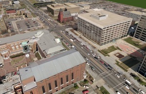 Urban Models with ossimPlanet (Washington DC)

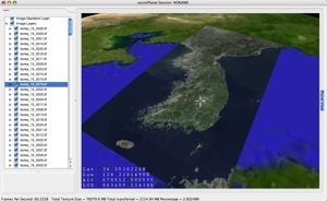 Mosaic of Korea with ossimPlanet

OMAR is a web based ossim service that rapidly provides new products to end users.
Areas for Improvement
OSSIM is currently in incubation awaiting final graduation. Work is continuing on documenting the wiki and improving the communications from the Program Steering Committee to the developer list.
OpenLayers
- Period covered by report: Jan-Dec 2007
- Contact name: Chris Schmidt and Erik Uzureau
Key Accomplishments
- Graduated from OSGeo incubation
- Three major releases in 2007
- 2.3:
- Bug fixes from 2.2 release
- Improvements in tile handling
- Support for TMS
- 2.4:
- Vector drawing support
- Improved event handling framework
- New editing controls
- 2.5:
- Additional format support: KML, GeoRSS, GeoJSON
- More vectorization tools
- Better third party API integration
- Improved system for developer documentation
- 2.3:
- Many, many new participants:
- 250+ subscribers to developers list
- 550+ subscribers to users list
- Over 110 users manually signed up for TRAC accounts
- Integration of OpenLayers into existing toolkits: MapBuilder, Fusion, and MapFish
Areas for Improvement
- Plan to migrate to OSGeo infrastructure for SVN/Trac
- Process to become a committer better defined (add more committers, add reviewer role, etc.)
- Better documentation, memory handling
- Continue to expand support for existing Geo standards.
Opportunities to Help
- Case Studies: Why are you using OpenLayers? What do you gain by using it over other tools?
- Examples:
- Documentation: Prose text describing how to perform a series of steps to achieve a goal in OpenLayers, to add to the existing developer documentation and examples
- Improved interaction with current users of proprietary software to understand and target their needs, including (but not limited to):
- Possibly developing support for ESRI-specific map requests like ArcXML
- Improved documentation on how to transition from proprietary software to OpenLayers
Outlook for 2008
In 2008, OpenLayers is poised to continue on its current trend of taking geographic information to the web. With support for new geographic formats and servers, improved performance, and web browsers becoming more and more commonly used as the sole client to access datasets, OpenLayers has placed itself in a strong growth position. Patches and contributions are arriving from around the globe, from contributors on 5 different continents.
In 2008, expect to see wider usage of OpenLayers as the project becomes more widely used and better documented. Already, we have seen major governmental organizations take up OpenLayers as the sole public API to their data, preferring the open source project to commercial ventures such as Google, Yahoo, or Microsoft's offerings. With this trend, it is likely that users can expect to see continued usage leading to wider support for different browsers, improved functionality, and more in 2008.
Quantum GIS
- Period covered by report: Jan-Dec 2007
- Contact name: Gary Sherman
Key Accomplishments
- Released versions 0.8, 0.8.1, 0.9, and 0.9.1
- The refactoring of libraries (starting at 0.8) allows the development of standalone GIS applications using the QGIS API
- Version 0.9 introduced Python bindings, opening up QGIS development to a larger audience
- Improved project management by establishing roles with the Project Steering Committee (PSC):
- Release Manager
- Technical Advisor
- Community Advisor
- Financial/Marketing Advisor
- Entered OSGeo incubation in February
- Funds management was transferred to OSGeo
Areas for Improvement
- any weaknesses in process, software, management, etc. that you plan to address or recognise need some help
- The QGIS project continues to improve its internal processes for development and release of packages.
- There are a number of key shortcomings (labeling, map composition) that need to be addressed for the release of version 1.0 in 2008
Opportunities to Help
- QGIS is in need of additional developers to close existing bugs and implement new features.
Outlook for 2008
- this is the motivational part that is meant to inspire readers to keep their eyes open for great stuff in 2008 :)
- Version 1.0 will be released in 2008, providing a stable API for the development of both C++ and Python applications
MapGuide Open Source Report 2007
Mapbender
Retrieved from http://www.mapbender.org/Annual_report_2007
- Period covered by report: Jan-Dec 2007
- Contact name: Christoph Baudson, christoph@osgeo.org
Key Accomplishments
(the top 5-10 key items that the project or PSC accomplished this period)
quality assurance
- increased the percentage of re-usable code by switching from script-oriented to object-oriented design
- since 02/07: well-used bug tracking system Trac supplied by OSGeo (163 tickets up to now), supplement of patches for bugs.
- since 03/07: well-defined release proceedings, releases on a regular basis (at least 4 releases per year)
- 12/07: optimization of Mapbender's load process: it now loads 4-5 times as fast.
- since 04/07: growing HTML API of JavaScript and PHP classes, for example https://svn.osgeo.org/mapbender/trunk/documents/jsdoc/index.html
- 01/07: establishment of coding conventions, see http://www.mapbender.org/index.php/Code_conventions
community building
- since 03/07: regular, productive weekly IRC meetings, see logs at http://www.mapbender.org/index.php/IRC_Meeting
- 05/07: development sprint with around 20 participants
- since 01/07: integration of several new developers outside of the core team (Michael Schulz, Marc Jansen, Marko Samson etc)
- since 07/07: development of internationalisation techniques (in collaboration with italian developers)
- multi-language documentation at www.mapbender.org
Areas for Improvement
(any weaknesses in process, software, management, etc. that you plan to address or recognise need some help)
- enhance international outreach, address more people outside Germany (or Europe)
- develop an easy-to-use update routine
- integration of OSGeo software, like OpenLayers
- despite having an opportunity to host demos at Telascience, a machine with better connection to Europe might be desirable. The server is very slow here.
Opportunities to Help
(list areas that could use some help from members and readers of the report)
- Wiki: Request for an Account and add your web application to the Mapbender Gallery or help on the documentation
- Contribute your set of buttons to make Mapbender look better
- Offer service around Mapbender, there is still a lot of commercial potential
- Join development by throwing code over the fence or joining the core development team. We need people who have fun creating Web 2.0 style interfaces and have a hand for design work
- Fund core development by sponsoring
Outlook for 2008
(this is the motivational part that is meant to inspire readers to keep their eyes open for great stuff in 2008 :))
- release of Mapbender 2.5, featuring i18n, KML support, optimized code etc.
- stabilise and enhance input/output of standardized formats like WMS, WFS, WMC, GeoJSON, KML
- continue to work on re-design to allow interoperation with state-of-the-art software
- WFS FilterEncoding interface - this means that you can query geographic objects for spatial and attribute data
- SLD Editor
- Install / Setup script
- Catalog connectors
- Enhanced update functionality
- new interfaces (badly needed, we still look like from the late nineties...)
Maybe (depending on interest - so ask for it!)
- OpenLayers as alternative map interface
- FeatureServer support
- Tile cache support
- Provided at Strategic Direction - February 2008
OSGeo participation in Google Summer of Code 2007
by Wolf Bergenheim
Last summer, from May 1st 2007 to August 31st 2007, OSGeo participated in the Google Summer of Code. This article sums up that experience and gives a short presentation of each Summer of Code project.
What is SoC?
Quoting Google FAQ
Google Summer of Code TM is a program that offers student developers stipends to write code for various open source projects. Google will be working with a several open source, free software and technology-related groups to identify and fund several projects over a three month period. Historically, the program has brought together over 1,000 students with over 100 open source projects, to create hundreds of thousands of lines of code. The program, which kicked off in 2005, is now in its third year, following on from a very successful 2006.
While the majority of past student participants were enrolled in university Computer Science and Computer Engineering programs, GSoCers come from a wide variety of educational backgrounds, from computational biology to mining engineering. Many of our past participants had never participated in an open-source project before GSoC; others used the GSoC stipend as an opportunity to concentrate fully on their existing open source coding activities over the summer. Several of our 2005 students went on to become mentors in 2006.
What projects participated?
First of I'd like to congratulate the students on a job well done. A lot of cool and very usefull projects were completed in SoC 2007. We did loose a student or two, who were overtaken by other priorities. But the overall success of projects is something we should be proud of. Good work! Hope SoC 2008 will be at least as good.
Now on to present the Projects of Summer 2007.
GDAL
GDAL2Tiles
Student: Klokan Petr Pridal Mentor: Howard Butler
This project is to allow easy publishing of raster maps on the Internet. Raster maps (like TIFF/GeoTIFF, MrSID, ECW, JPEG2000, JPEG, PNG) are converted into a directory structure of small PNG tiles (TMS compatible), which can be copied to a webserver. Simple webpages with viewers based on Google Maps and OpenLayers are also generated as well. This tool makes publishing even large maps without needing to install or configure any special software (like mapserver) and the map displays very fast in the webbrowser. GDAL2Tiles also generates necessary metadata for Google Earth (KML SuperOverlay), if the supplied map uses EPSG:4326 projection. The gdalwarp utility can be used to convert raster maps with another projection. World files and embedded georeference is used during tile and KML generation, but proper georeference is not mandatory.
Tile structure follows recommendation from OSGeo Tile Map Service Specification
Manual page for utility is part of the solution, as well as a document describing several existing tile structures with links to further documentation. Analysis of rotated SuperOverlay KML is done as well.
For more info look at the project page
This project was accepted by GDAL community as ticket #1763. This utility is distributed with the new stable version of GDAL 1.5.0.
KML read support for the existing driver
Student: Jens Oberender Mentor: Mateusz Loskot
This project added KML vector read support.
For more information read Wiki page
This project is included in the new version 1.5.0 of OGR
Web Map Services GDAL driver
Student Adam Nowacki Mentor: Daniel Morissette
Development of a OGC Web Map Services GDAL driver, with support for the following Web Map Services:
- OGC WMS and WMS-C cache
- WorldWind TileService
The new driver has been included in the official GDAL codebase and included in the 1.5.0 release. Driver documentation is available and the Wiki page hase more information.
This project is included in the new version 1.5.0 of OGR
GRASS
v.generalize
Student: Daniel Bundala Mentor: Wolf Bergenheim
v.generalize is a project which does line simplification as described by McMaster. The original plan was to implement Douglas-Peucker and a few more line simplification algorithms. Daniel Bundala (the student) surprised his mentor by working a lot more efficiently and as a result GRASS 6.3 now includes a brand new generalization module which is capable of not only simplification but also smoothing and displacement. There is also a method for network simplification in the module.
For more information see the module documentation
v.generalize is included in the new 6.3.0 release of GRASS (as of RC4).
The module has also been used to substantially speed-up and improve quality of interpolation from contour data when computing digital elevation models.
v.net.visibility
Student: Maximilian Maldacker Mentor: Wolf Bergenheim
v.net.visibility builds a visibility network around some obstacles. The created network can then be further analyzed with existing v.net.* modules. It can also be merged with an existing network, like a road network, and this enable plotting shortest paths beyond an existing road network, say for emergency vehicles.
For more information see the module documentation
v.net.visibility is included in the new 6.3.0 release of GRASS (as of RC4)
uDig
Caching data
Student: Christophe Rousson Mentor: Ian Turton
A feature cache. A RAM cache might use the LRU algorithm and have a maximum amount of RAM to consume setting. A local disk cache and local disk cache might use a size-only and/or maximum age based algorithm. Ideally as items fall out of RAM, they would be written to disk. At session close, remaining items in RAM would also be written to disk (much like Google Earth). Upon startup, cache could be polled to see if anything already exists within the current spatial window (if it hasn't expired).
For more information see the data Wiki page
This project is on the trunk/development version of uDig.
Transformation Algorithms
Student: Jan Jezek Mentor: Jesse Eichar
GeoTools Referencing module has been becoming one of the most powerful tools focused on coordinate system transformations in JAVA GIS world in recent years. Referencing module in conjunction with Coverage module presents a really strong tool for raster operations like re-projecting and transforming. One of the frequently required operations in GIS is to fit rasters like scans of maps or remote sensing images that have unknown coordinate reference system into the real world coordinate reference system. In GeoTools there are already few possibilities to do so. The aim of this project is to add other algorithms for that purpose and then to make a simple GUI for uDig to apply these new functions.
These new algorithms are:
- New interpolation-based methods - inverse distance weighted (IDW) interpolation, bilinear interpolation.
- Thin-plate Spline method (TPS).
- More general piecewise transformation.
For more information see the Wiki page
This project is on the trunk/development version of uDig.
Interactive GeoRSS Tool
Student: Rui Li Mentor: Richard Gould
As a user focused geographical information system, one of its goals is to satisfying system users by providing sufficient information to their specific needs. In many cases like traveling or moving, a traveler would like to find Places of interest close to his/her hotel, or a student wants to find an apartment within feasible walking distance to school. The traditional way contains two separate steps which are looking for potential locations and then confirming the distance by the user him/herself. This project combines the two steps together.
For more information see the Google Summer of Code abstract
Geoserver
JTileCache
Student: Chris Whitney Mentor: Justin Deoliveira
Implemented a WMS-C server (similar to TileCache of MetaCarta) as a Java servlet, including support for existing cache libraries in order to support memory, disk, and distributed caches. The Open Planning Project (TOPP) is continuing development on the project. In particular, Arne Kepp contributed significant new features and bug fixes, including releasing a 0.5 version under a more suitable name, GeoWebCache. The project currently lives at http://geowebcache.org. The GeoServer demonstration site now uses GeoWebCache for serving WMS tiles to the client.
Style Editor
Student: Anthony Manfredi Mentor: Andrea Aime
To design and implement an editor for SLD files with using JavaScript.
- Standalone - editor is not tied to a particular program (uDig, MapBuilder, GeoServer)
- Visual - users can preview the results of changes as they are made.
- Intuitive - easy to learn but not cumbersome or limiting for the advanced user.
For more information see the Wiki page
GeoTools
Multi-Dimensional Raster Data Sources
Student: Daniele Romagnolil Mentor: Simone Giannecchini
This is a set of Java Image I/O plugins capable to provide a starting point for building GeoTools plugins to manage multidimensional data formats such as NetCDF, HDF, GRIB1.
- HDF (Hierarchical Data Format) is a library and a multi-object file format
created and developed by NCSA (http://www.ncsa.uiuc.edu/).
- NetCDF. Quoting from (http://www.unidata.ucar.edu/software/netcdf/), "NetCDF (network Common Data Form) is a set of software libraries and machine-independent data formats that support the creation, access, and sharing of array-oriented scientific data."
- GRIB1 is a data format standardized by the World Meteorological Organization's Commission (http://www.wmo.ch/) for Basic Systems, which is commonly used in meteorology to store historical and forecasted weather data.
For more information see Wiki page
3D Rendering Pipeline
Student: Hans Haggstrom Mentor: Jody Garnett
The 3D Renderer provides a three dimensional view of GeoTools geographical data. It uses the normal 2D renderer for rendering the surface texture. It implements a level of detail based loading and caching system for the geographical data to speed up rendering, and allow perspective views showing both nearby and far away features at the same time. Possible future improvements are rendering elevation data based on height coverage data. In addition, there could be support for some common 3D rendering styles that can be used for features consisting of points, lines, and areas.
For more information see Rendering Pipeline for GeoTools Wiki page
PostGIS
Coverage Model and Operations
Student: Xing Lin Mentor: Timothy Keitt
This project includes a raster data model and its storage in PostGIS. Import and export tools are also available for popular image formats. There is a paper about this project available at http://ieeexplore.ieee.org/xpl/freeabs_all.jsp?arnumber=1370128
For more information see the Google Summer of Code abstract
Mentor Summit
Some (well behaving, meaning turning in their surveys in time etc.) projects were asked to send a mentor to the SoC Mentor summit. OSGeo sent me (Wolf Bergenheim from the GRASS project). Mentors from over 100 projects joined forces at Google HQ in Mountainview CA, and discussed varied aspects of the SoC. The summit was arranged as an unconference, meaning that the participants generated the program. A wiki with the talks is set up at http://googlesummerofcode.jot.com/
Lessons learned
Many lessons were learned in the SoC 2007 (at least by me), both as a mentor, but also general points on how to attract more developers and how to "keep" SoC students with the projects. Burst let me talk about how to attract students.
How to attract students?
We did get about twice as many projects proposals as we had slots available, but compared to other projects it was actually quite slim. I will now discuss how we could maybe attract more students this year.
Promise fame and glory
With this I mean that it should be clearly indicated that the students will be given "media time". This means spotlights at the OSGeo website, maybe even a news item telling about their prograss. And similar exposure within the project that they work.
Show that you appreciate their work
The code that the students produce should end up in the main code repository, and it should be made clear from the start that this will happen. Also We should promise to include their project in the next release after it is completed. If we promise that their code will become part of the project it should motivate the students even more.
Have interesting but a vague ideas list
When we compose a project idea list we should leave room for innovation. Let the students fill the gaps. That way we will attract maybe the more correct types.
Work with the student from day 0
This means that when you see an interesting application, take the time to set up a wiki page to flesh out the idea with the student. Last year there was plenty of time to talk things with the would be students. Chatting on IRC is also good. When the students see that we are committed to the SoC and that we listen to them they should become more interested.
Integration to the community
Once we have selected the best students to work on the coolest projects we should integrate them into the community to hopefully get new eager committed developers (fresh blood, as I like to call it). How do we accomplish that?
Have the student talk on public mailing lists and IRC channels
Most, if not all project communication should be on the main project development list and IRC channel. If the student is shy, one trick is to say "I don't know, try the developers list" Once they get used to sending mail there (and see that nobody bit their head off) they should have no problem in becoming integrated, maybe they might even answer some unrelated emails.
Make sure that the whole project knows about and is aware of the SoC
If the whole project knows about the student, they will help you make him feel welcome.
Help them finish successfully
If the student struggles, chances are that he won't finish the project. If he is provided with help and a whole community of supportive developers, he won't have to struggle as much, and he will most likely finish.
Keep the student happy
A happy developer is a productive developer. If the student feels welcome and liked he will probably enjoy being part of the community, and thus will most probably stay with us.
Cross-project cooperation and cooperation outside OSGeo
There was also talk about collaborating with other organizations over the SoC. For us this means either that we could come up with SoC projects which involve more then one OSGeo project, or it could mean that we collaborate with a non OSGeo project like Drupal. Drupal has shown interest in collaborating with PostGIS regarding geo stuff. This means that we could give them one mentor to help with geo things while they would give us a mentor to help with the PHP. It could be one or two projects.
Wrap-up
Last year SoC came a bit like a surprise for us at GRASS, so we were not really able to organize ourselves to bring more SoC project ideas, but in the end we were able to finish two students. Also last year was a bit confusing and maybe not as organized as it could have been. Mentors from other projects didn't seem to talk together and it felt a bit like a fragmented effort. This year I hope to be able to use the knowledge gained from last year to make it easier and less confusing to new mentors, and maybe have a more united OSGeo SoC experience.
Some words from Our students
Two students, Chris and Daniel, felt like sharing their SoC experience with us.
Chris Whitney
I enjoyed participating in Google Summer of Code. The project was my first experience working on a GIS software project, and definitely my first exposure to many of the open-source GIS projects. Fortunately, the Geoserver community was a very knowledgeable and friendly environment for starting my project. I was sponsored by Google to attend FOSS4G 2007, which was an exciting opportunity for me to present my project and learn more about OSGeo-related technologies.
Daniel Bundala
Here, I would like to make some comments on my experience with GRASS, Summer of Code and such. This is not very official, however, I hope that some people may find this quite useful and/or interesting.
When I applied to SoC, I had absolutely no experience with GRASS or any other GIS. Actually, my only experience with any digital maps/geography/whatever was via Google Maps. I had never had a need to use anything else before and so I had though that it is basically the only thing one may ever need. It did not take a long to realize how wrong I was...
In general, I was very satisfied with my work on GRASS; definitely, it was much better than I expected. I learnt, many new algorithm and methods that I implemented into GRASS. Also, the courses on linear algebra and calculus I have taken were quite handy at some point. Finally! Moreover, I am now more experienced and confined user of GRASS. I recall, that during the first few weeks, I did everything with mouse and worked almost solely with GUI. But at the end of the summer, I discovered the beauty and effectiveness of command line and so I run GRASS in text mode only now...
One particular event, I still remember, is that Wolf, my mentor, once sent me a paper concerning some vector generalization I worked on. This would not be a big deal if it were not in German. I really believe, that my German teacher would be proud of me as I read it and understood what was it about. Well, maybe not, as after 4 years of "intensive" study I was able to understand not even the every other word.
To sum up, I have to say, that I spent the last summer very productively. I still read GRASS mailing list almost every day. Partially, because I want to know about any possible bugs in my module, but mostly because I am still interested in the project itself. Also, it was great programming/linguistic experience and I hope I will be able to repeat it at some point in the future.
Local Chapter Reports
= Project Name = Africa Chapter
- Period covered by report: Jan-Dec 2007
- Contact name: Gavin Fleming
Key Accomplishments
- won the bid to host FOSS4G2008 in Cape Town, South Africa, from 29 Sept to 3 Oct.
- kept the africa list going - standing at 178 members. It was quite active during the year with amongst other topics several FOSS GIS courses announced in East and South Africa.
Areas for Improvement
- none stand out
Opportunities to Help
- Come to FOSS4G2008! Present a workshop or paper! Help with organisation! Sponsor!
- Help with Africa chapter formation processes
- Offer courses, training, support generally for FOSS GIS in the region as much capacity building needs to take place with the South African government having adopted a FOSS policy.
Outlook for 2008
- FOSS4G2008 is going to be a fantastic event, make sure you're there!
- This year I hope to go through the formalities of launching the Africa Chapter, which till now has been an informal grouping. There's no reason it has to be an Africa Chapter and not several regional or local chapters, but perhaps an Africa one is best to start, then local or language based ones can hive off when they get critical mass.
Australia / New Zealand
- Period covered by report: Jan-Dec 2007
- Contact name: Tim Bowden
Key Accomplishments
- Prepared a successful bid to host FOSS4G in 2009.
- Generated interest in OSGeo and FOSS4G in Government, Industry and the Australian Open Source Community.
- Presentation and booth at linux.conf.au, Sydney, January 2007.
- Booth at Spatial Sciences Institute International Biennial Conference, Hobart, May 2007.
- Presentation and booth at GITA 2007 Geospatial Infrastructure Solutions Conference, Brisbane, August 2007.
- Presentation to Victorian Department for Primary Industries Spatial Sciences Workshop, Melbourne, September 2007.
- Obtained legal advice on best structure for incorporation as a non profit organisation. This proposal has been endorsed by members of the Chapter.
Areas for Improvement
- We need to develop protocols and processes to ensure smooth running of the chapter.
Opportunities to Help
- Assist with the planning and preparation for FOSS4G 2009.
- Offers of Patronage will be greatly appreciated.
Outlook for 2008
- Incorporate OSGeo Australia / New Zealand as a not for profit organisation.
- Seeking Patronage to ensure the future of the chapter.
- Advocacy to spread the word of the quality FOSS4G software available.
- Planning and preparation to ensure an outstanding FOSS4G 2009.
Annual Report
- Period covered by report: Jan 2007 - March 2008
- Contact name: Rafael Medeiros Sperb
Key Accomplishments
- Third Brazilian Mapserver Users' Meeting - ENUM
This meeting was held in May 2007, in the auditorium of the Federal Government Palace, in Brasilia.
- Public Audience of e-PING
This meeting was held in Sept 2007, in the auditorium of the Ministry of Health, in Brasilia.
Areas for Improvement
- OGC WMS and WFS recomendation.
- I3GEO is now distributed under Creative Commons License.
 Demo
 Download
Opportunities to Help
- OSGeo members can support local initiatives for organizing the Brazilian Chapter.
- We seek help for organizing all documentation to request I3GEO incubation under OSGeo.
Outlook for 2008
- Fourth Brazilian Mapserver Users' Meeting - ENUM.
British Columbia Local Chapter
- Period covered by report: Jan-Dec 2007
- Contact name: Martin Kyle
Key Accomplishments
- Held initial meeting of unofficial OSGeo chapter to gauge interest
- Twenty-two people in attendance linked across two geographies (Vancouver and Victoria)
- Democratically established direction for local chapter charter
- Setup Local Organizing Committees to individually plan alternating meetings for each location.
- Submitted charter and recieved official approval of local chapter
Areas for Improvement
- So new...nothing, everything.
- Probably need to relax Robert's Rules of Order a bit
Opportunities to Help
- Talked about organization of Prince George (and other) group to link into the BC meeting.
- Any interested people in that area with a Video Conference link could join in with Vancouver and Victoria.
- Presentation ideas welcome
- Currently focused around two streams: application and technical
Outlook for 2008
- Meetings held quarterly
- Presentations and project ideas to gel the community have begun.
- First real presentation-based meeting to be held February 29, 2008.
- Project possibilities include live demo and outreach program.
California Local Chapter (Proposed)
- Period covered by report: Jan-Dec 2007
- Contact name: Landon Blake
Key Accomplishments
- Mailing list established for proposed chapter.
- Temporary incubator website for the chapter created at http://www.redefinedhorizons.com/calosgeo/.
- Alex Mandel and Landon Blake explored the possibility of an OSGeo Booth at the California Geography Society meeting in Chico, California, in May 2008
Areas for Improvement
- Possibility of splitting proposed chapter into sub-chapters because of the size of the state.
Opportunities To Help
- Coordinate and support OSGeo Booth at California GIS Conferences
- Coordinate OSGeo ambassadors to GIS related organizations in California. (Examples: California URISA Chapters, California Land Surveyors Association)
- Forward movement on any of the proposed chapter goals listed here: http://wiki.osgeo.org/wiki/California
Outlook for 2008
- Formation of California Chapter unlikely until support from interested members increases.
China Local Chapter
- Period covered by report: Jan-Dec 2007
- Contact name: Gao Ang
Key Accomplishments
- Held regular meeting of OSGeo China chapter.
- Put forward the activities of OSGeo China such as giving lectures for the Chinese University students.
- Modify GRASS commands for data processing and analysis to C-API functions.
- Build another GRASS GUI for Linux and Windows based on QT using C-APIs, similar to QGIS and ArcMAP.
- Research and analysis Ingres database and try to enhance spatial extension.
- Start open source project JavaPWS to implement the OGC-WPS Specification.
- Publish three articles about Open Source GIS at <Programmer> magazine in Chinese.
- Google Group Mail List for OSGeo China Members.
Areas for Improvement
- We should organize open party for the technical discussion.
- We should introduce OSGeo in more areas as meetings, magazines and events.
- We should contact with other Asia countries related with OSGeo.
- Add useful content to OSGeo China website.
Opportunities to Help
- We are looking for more opportunities for cooperate and communication.
- Encourage more people to join the OSGeo China mailing lists.
- Make contribution for the local open source project related with GIS.
Outlook for 2008
- Improve our presence in China, especially during the Beijing 2008 Olympic Games.
- Formalize the OSGeo China Local Chapter.
- Publish more articles in magazines related with Free GIS.
- Make plans to give lectures for the university student.
Spanish Language Chapter
- Period covered by report: Jan-Dec 2007
- Contact name: Jorge Sanz, Lorenzo Becchi and Víctor Olaya
This text is a short version of the bigger article written by OSGeo Spanish group for the Girona meeting.
Key Accomplishments
Community support
- Mailing list
- The center of our activity, like for any other OSGeo group, is the mailing list. Thank to this tool, all subscribers can interact discussing, resolving technical doubts, promoting local events, chatting about interesting news, links and so on. Regardless their location and technical skills, anyone can ask for help about geomatics and FOSS4G software.
- wiki
- We have set up a category for Spanish contents called Español. Every content we have to write about finds its place in the wiki and everybody is invited to contribute or share his opinion (using talk pages). We use it to plan and manage the Free GIS Book, the contents, the authors subscription and so on.
- OSGeo site translation
- It's very important to maintain and update the Spanish version of the OSGeo site. Coordinated with the Website Committee, the translation of the most important pages of the web is completed.
Presentations
- FOSS4G2007
- Lorenzo Becchi presented the initial movements of the Local Chapter at FOSS4G in Victoria, Canada.
- 3rd gvSIG meeting
- The Local Chapter was presented to the gvSIG community in their annual meeting.
- 2nd Free GIS meeting in Girona
- This is the annual meeting for Spanish FOSS4G users and developers, where this Local Chapter was formed.
Free GIS Book
The Free GIS Book is one of the most important initiatives of the Spanish Local Chapter. With the leadership of Víctor Olaya, a group of authors have organized a common effort to create a book about Geographical Information Systems from the theoretical point of view, agnostic of any specific software and covering the main areas of that discipline. This is a Free content project, using a Creative Commons license (2.5 CC-BY-SA) and supported by OSGeo infrastructures.
Collaborative structure
We have elected a PSC and a set of rules to participate in the book. Every chapter has a main author, responsible of coordinating their contents with other authors as usual in collaborative books.
Parts
The book has six main parts, everyone with several chapters:
- Introduction: First concepts and fundamental ideas about GIS, its history and a global overview
- Data: Geographic data particularities, representation models, data storing, data bases and quality among other topics
- Processes: Formulae and algorithms related with geographical analysis from simple queries to network analysis or terrain models algorithms
- SDI: The Spatial Data Infrastructures play an important role in the way we use and produce data
- Technology: This part presents the main types of GIS softwares, their characteristics and technical fundamentals as well as the main representatives of any type.
- Applications: How GIS are applied to specific fields. How previous topics apply to any case, and how other particular elements also support that fields.
Tools
The book is being written in Spanish, using LaTeX as editing tool and OSGeo SVN repositories as a version control.
Areas for Improvement
- We should to present OSGeo in more areas as geomatic meetings, journals and events.
- We should to formalize the Local Chapter electing a PSC.
- We should contact with other Spanish spoken communities related with specific projects.
Opportunities to Help
- We are looking for more translators for:
- OSGeo website
- OSGeo flyers and marketing stuff
- The Journal
- ...
- People to join and debate on the mailing lists!
- If you want to start to translate into Spanish of one of the OSGeo projects, we can help as bridge to the project community
- Present OSGeo projects in your local community
Outlook for 2008
- Formalize the Local Chapter
- Improve our presence in South America
- Keep going the Free GIS Book project
- Improve translations
Francophone Chapter Report 2007
Contact : Yves Jacolin (President of the Francophone Local Chapter)
OSGeo-fr Board : Gwenael Bachelot, Vincent Picavet, François Van Der Biest
Introduction
This report summarises the actions undertaken by the Francophone Local Chapter and milestones achieved during year 2007. It covers the period from January to December 2007.
The "Francophone" mailing list has been created in October 2006. First tangible actions have been initiated at the beginning of 2007 and have dealt with the organization of the Local Chapter. At present, the Francophone Local Chapter is close to adopt a legal representation as an official French association with legal status. It will make contribution to the GFOSS French-speaking community easier.
2007: creation of the Francophone local chapter
With the creation of the Francophone mailing list a large number of interested people in organising a local chapter to promote GFOSS in French language has been gathered. Year 2007 was dedicated to the organisation of the local chapter and to make it an official OSGeo local chapter. Several points have thus been addressed and numerous questions had to be answered:
- Definition of the local chapter structure and its organisation: definition of a steering board and of sub-committees in charge of thematic and specific aspects, election of board members, internal rules, membership, etc.;
- Clear and consensual definition of the goals of the local chapter;
- Definition of the communication processes through the wiki;
It was not an easy task but guidelines and help provided by the OSGeo have contributed to achieve it in a reasonable amount of time. Indeed, most of the questions or problems the Francophone local chapter has faced were the same for all other OSGeo representations. So answers were often very similar. The Francophone local chapter is now organized in three sub-committees. They respectively deal with “free organization”, “free data” and “free software”. A steering board with 4 persons has been elected in 2007 for a one year mandate. The board manages the Francophone Local Chapter projects. For time-consuming projects and specific questions, a dedicated manager can be assigned by the board. He or she is selected among volunteer active members of the mailing list. In September 2007, the OSGeo Board has accepted the proposal for the creation of a Francophone Local chapter. It is now an official local chapter of OSGeo.
In 2007, actions have mainly focused on increasing OSGeo visibility in Francophone countries, aka marketing missions. Two projects have thus been carried out: 1) important participation and communication in two major geospatial tradeshows (GeoEvenement 2007 and GeoTunis 2007) where several presentations about OSGeo, OSGeo-fr and OSGeo projects have been performed and information to a large public have been provided; 2) the translation of the OSGeo journal. The first two volumes of the OSGeo journal have been translated and are now published. They can be downloaded from the OSGeo Journal home page. In addition, all the news and approximately half of the web site have been translated in 2007.
Participation to the 2008 edition of the GeoEvenement tradeshow is planned and the organisation of a more important open source village than the one set up during the 2007 edition is anticipated. The number of conferences given during this tradeshow should increase too.
2008: one year to improve our organisation
Year 2008 will be dedicated to the creation of a legal representation (as a French association with legal status) for the OSGeo Francophone local chapter. Such a legal organisation will help to manage sponsorship, to organize various events in the name of a legal entity, etc.
We would also like to improve our internal working, decision and communication processes, by creating dedicated working groups on specific subjects such as translation, event organization, sponsorship, and so on.
A list of possible actions to carry out in 2008 has been initiated. It will be submitted to a consultation and a vote in order to prioritise actions to be undertaken. The result will define the roadmap of the local chapter during year 2008!
Conclusion
As abovementioned, many actions are planned for year 2008. It demonstrates the increasing involvement of the local chapter to promote geospatial FOSS and free data. The local chapter will thus:
- participate to GeoEvenement 2008 (the major geospatial tradeshow in France) and will organise a more important open source village than the one set up during the 2007 edition of this conference;
- try to organise a Francophone FOSS4G conference, in France;
- work on free data opportunities;
- perform further translation works in addition to pursue the translation of the OSGeo journal on a regular basis;
- initiate new exciting projects to promote free and open source software and data in French language.
Preface
The main focus of the vocal bits of the German language OSGeo community has been to spread word and promote GIS and WebGIS solutions with Free Software.
Key Accomplishments
The most appropriate way to accomplish this over the last years was to organize and take part in events. In 2007 we had various of them:
- FOSSGIS Konferenzen
- The German language Open Source GIS community meets at the FOSSGIS conference. It is the largest annual conference focusing on FOSSGIS and sees growing numbers of attendees very year.
- OSGeo Park at the Intergeo
- The Intergeo is the largest recurring GIS event, trade show and congress in Europe attracting more than 10k people. The OSGeo Park hosts a presentation forum for users, free-of-cost booths for OSGeo projects and is funded by FOSSGIS companies exhibiting. It is a perfect example of Coopetition. Get some impressions from the Intergeo_2006_Report.
- OSGeo operated the Open Source Park of the Intergeo together with the Hinte-Messe GmbH, organizer of the exhibition and conference.
- With an exhibition area of 30 by 20 meters the OSGeo Open Source Park was one of the largest booths at the fair.
- Focus of the Intergeo trade show is clearly business and end customer oriented.
- Of the 16,000 Intergeo visitors several thousand made it to the OSGeo sector to pick up info sheets and listen to presentations.
- Those who wanted to get more detailed information talked to the booth staff of roundabout 30 people from all areas of IT and FOSS GIS business.
- The Open Source-Day at AGIT
- This event is focused more on scientific attendees and has a strong academic foundation.
- The recurring special seminar focusing on Free and Open Source Software methodologies in the spatial context is in its fifth year now.
- OSGeo presence at the LinuxTag
- 2006 was the first public appearance of OSGeo in Germany
- 2007 saw the joint effort together with the GAV eV.
- OpenStreetmap presented on the OSGeo booth
What else did we do?
- Create info sheets for OSGeo projects and translate them to English
- Start translation of the OSGeo Homepage to German
- Lots of presentations and articles focusing on FOSSGIS and business models
- publishing articles like OSGeo at GIS BUSINESS - GIS Business Magazin
- publishing articles like OSGeo at GIS BUSINESS - GIS Business Magazin
Areas for Improvement
The FOSSGIS community in Germany is quite heterogeneous and reaching consensus is a long process with frequently more or less fruitful discussions on various topics. One reason may be, that the history of Free Software in Germany goes back quite a long time - well before OSGeo came into existence. Some initiatives still have sensitivities and face problems in sharing the role of Free Software promoters with others.
Outlook for 2008
Events, conferences (FOSSGIS 2008, AGIT 2008, LinuxTag 2008, Intergeo OSGeo-Park 2008). Eventually we would like to have an organization that is well embedded into OSGeo but also has a local focus to be able to collect funding from European grant programs and the public administration. Currently it is not possible for the public administration to fund OSGeo directly. Whether "OSGeo Local Chapter" is an appropriate terminology is one of the ongoing sensitivities.
Greek Language Chapter
- Period covered by report: Nov-Dec 2007
- Contact name: Dimitris Kotzinos
- The OSGeo Greek Local Chapter was initiated only in November 2007. So we cannot really speak on accomplishments but we are mainly happy that the effort has received a lot of recognition and (only vocal for the moment) support.
Key Accomplishments
- 1-Day Workshop on FOSS GIS, 23rd of November 2007, Athens, Greece.
The participation in this event was overwhelming. Instead of the expected participation of 60 people, a mere crowd of 160 was gathered to attend a rather unpublicized event.
Areas for Improvement
- We still do not have the participation in OSGeo I expected when the effort was started about 3 months ago. We need to intensify the efforts to increase the membership and the overall awareness.
- We also need some more media catching events. We are working on ideas on that but the limited to non existing resources are always a big barrier to overcome.
Opportunities to Help
- In the future we will definitely need some speakers for national FOSS or just simple GIS events.
- We would also like to demonstrate some cases of successful use of FOSS GIS by the public sector to local government officials.
- We would like to plan some demo classes on FOSS GIS for students in universities integrated them in there curriculum in order to show that we can achieve the exaxt same educational result.
Outlook for 2008
- We plan to organize a special session on the national GIS conference (HellasGI 2008).
- We also plan to organize a local web site (either standalone or as tightly integrated part of the OSGeo, this remains to be decided) that will provide access to free local data and translations of manuals of FOS software in the Greek Language.
- We also plan to have at least two more special events, depending on availability and funding.
- We would also be very interested in having the ability to apply for funding as a chapter/organization and we would like to seek help/information from other local chapters that do or plan to do the same.
Annual Report
- Period covered by report: Jan 2007 -Feb 2008
- Contact name: V.Ravi Kumar
- ravivundavalli@yahoo.com
- Co-Chairman events OSGeo-India
Key Accomplishments
- Events of OSGeo-India
- January 2007
- The OSGeo-India was officially born with its very first OSGeo workshop held at the Map World Forum, Hyderabad 22-25th January 2007. This well attended event was also participated by OSGeo delegates from China, Vietnam and Japan. Since then populasrising Open Source GIS was its main thrust through various, lectures, Workshops and exhibitions.
- February 2007
- National Conference on Biodiversity Conservation and Human Well-Being was organized by Department of Zoology, Osmania University and co-sponsored by SACON Deccan Regional Station, Hyderabad. The conference was held at Osmania University during February 8-10, 2007. SACON conducted a workshop on Wetland Informatics. It was aimed to address some of the issues related to spatial information generation, processing and data base design, dissemination and software development.In this workshop SACON presented Wetlands of India's website and it's future with the extensive use of FOSS tools. V.Ravi Kumar, of OSGeo India Chapter presented about the various FOSS4G's GIS software and their use taking the City of Hyderabad as an example. Prof K.S.Rajan, treasurer of OSGeo India chapter also actively participated in the proceedings. P.K.Sinha and A.V.Satya Kumar demonstrated FOSS GIS by showing OpenJUMP and it's userfriendly capabilities in performing vector GIS tasks like onscreen digitization of raster images to shape file with attribution.
- March-2007:
- National Convention On Free Software, 3rd - 4th of March 2007, Hyderabad, Andhra Pradesh included a session on 'Geospatial data'. Dr K.S.Rajan, and V.Ravi Kumar of OSGeo-India chapter, presented 'OSGeo phylosophy', and Open Source GIS alternatives respectively, which was attended by Free Software Foundation (FSF) enthusisasts from around the country. http://www.swecha.org/node/29 Society of Geoinformatics Engineering at Anna University, Chennai, conducted a two-day Geohorizon 2007 symposium (16-17 march 2007). There were four participants from OSGeo India chapter two on each day. Sri Neeraj Deekshith of Autodesk India and Santosh Gaekwad of SACON Hyderabad, presented use of Open Source Geospatial software in their organisations. Mr V.Ravi Kumar, and Mrs Mahalakshmi Narayanan presented 'Open Source GIS Galore', and 'Open Source GIS for web-services' respectively. Santosh Gaikwad presented the use of GeoSever for internet mapping of Wetlands of india. He delievered the SACON's experience while studying GeoServer- a open source server for Web-GIS. Use of Udig and GeoServer for publishing vector or raster maps onto web by storing the spatial data into PostGIS was demonstrated. http://societyofgeoinformaticsengineers.blogspot.com/index.html
- May 2007:
- On 11th May 2007 one day OSGeo-India workshop was held at, 'GIS Development', Noida (Delhi) with participants from the Indian geospatial community. They represented organizations like National Remote Sensing Agency, Centre for Development of Advanced Computing (CDAC), Tata Consultancy Servicesv (TCS), MapInfo, Adroitec, GIS Consortium, Eicher, 5Map, Infosys, Autodesk, National Institute of Health and Family Welfare, and Bharti Vidyapeeth's Institute of Computer Applications and Management (BVICAM). The workshop was opened by OSGeo-India representative Dr P.S.Roy, with an opening remark that,"GIS has emerged as an important technology tool. GIS initiatives need to be upscaled in terms of outreach and this is where OSGeo comes into play." One of the most important objective, from an Indian context, is to convert the free GIS tools like GRASS and MapServer in vernacular languages to form a large interest group. Dr. Roy also elaborated upon some of the noteworthy initiatives taken by organizations in India in the open source domain. V.Ravi kumar, who spoke about various FOSS GIS like GRASS, Quantum GIS, UDIG, Open Jump available today. The demonstration on 'Locating a Nuclear Power Plant', using Open Jump, was not only interesting but also testified how FOSS GIS can be equally useful as commercial GIS softwares. Ravi Kumar also talked in length about utility of FOSS GIS in India. The most pertinent point raised by him was that FOSS GIS is cost effective and can, therefore, become popular in a developing country like India. It can also provide employment through promotion of Village Cadastral GIS where all that one spends on, is a branded computer (available for less than Rs.20,000), as no cost is incurred on the software because it is, free and open. Sridhar Saraswati of Autodesk India, also gave a presentation, which answered a vital question- why is Autodesk supporting free and open source softwares? The reason is that firstly, Autodesk wants a broader adoption of Internet mapping technology and secondly, FOSS would create higher demand for related products. It would also be beneficial for the customers as the frequency of software releases will increase, cost of ownership will come down and there will be more innovation and support for standards. Satyajit Rath from CDAC, Noida presenyted 'CDAC's Initiatives on Open Source GIS'. 'Geospatial Convergence with Open Source' was presented by Amit Jain, of Infosys. The workshop came to an end with the closing remarks by Dr. P.S Roy. He expressed hope that "commercial softwares should invest in open source to make it a win-win situation for all."
- June 2007:
- The OSGeo-India chapter has conducted it's 1st Capacity building 3 day workshop from 26th to 28th June 2007 at Salim Ali Centre For Ornithology & Natural History (SACON) Hyderabad. The workshop was attended by -18- participants from NIC, NRSA, IIIT, Spec Systems, Army and Survey of India. All the participants were conversant with commercial GIS software and were eager to acquaint with FOSS alternatives. The 1st day included demonstration and hands-on practice with OpenJUMP GIS and map composition through Inkscape. The 2nd day was devoted to ILWIS GIS through raster analysis and generation of stereo pair and 3D visualization. The 3rd day was for using GRASS GIS for network analysis and creation of 3D visualisation and fly-bi. The participants were shown how one can join the OSGeo as a member and help spread the awareness. The resource persons were from Geological Survey of India.
- July 2007:
- A two hour lecture come demonstration of 'Open Source GIS GALORE', was presented by V.Ravi Kumar to the students of Geoinformatics post graduation course Nannaya University, Rajahmundry on 3rd July 2007. GRASS GIS and OpenJUMP were demonstrated using sample data. The students who could interact well in the question and answer session were presented GRASS6.2 Live CDs.
- October-2007
- Geology department, University of Rajasthan, Jaipur:
A knowledgeable crowd of students and research scholars and faculty members attended the Lecture cum demonstration. Prof Pandith, the Head of the Department took keen interest in arranging the event.
- November-2007
- Geology department, Karnataka University, Bangalore:
A very satisfying event was arranged by Prof K.L.Narahari Rao with a crowd of students and research associates showering the Lecture cum demonstration, with a very thought provoking interaction. The faculty were explained the catch-22 situation to be solved for Open Source GIS by taking various projects for implementation, thus popularizing the approach and paving the way for job opportunities.
- INCA XXVII (Indian National Cartographers association) International Congress, Visakhapatnam:
- The two day congress 21 to 23 November 2007, included a well attended exhibition with an OSGeo-India booth. The booth with attractive posters and live demonstration through an LCD projector was a big crowd puller. OSGeo-India booth distributed Open Source Geospatial software and GRASS GIS Live CDs to all those who have answered the OSGeo quiz and have given details of their email-Id and, how they intend to involve in the initiative. Specific demonstration of GRASS, OpenJUMP and Qgis were given to the interested visitors. By all accounts, OSGeo India’s booth was the most visited in the entire exhibition, with participants seen eagerly penning the Quiz and receiving the OSGeo India CDs.
- Civil Engineering Department, Gayathri Vidya Parishad, Visakhapatnam:
A very well attended ‘Demystifying GIS, OSGeo-India One Day workshop’, was arranged by Prof Veerabhadra Rao of Civil Engineering Department. The event started with a conference of the faculty and OSGeo-India representatives where in several forth coming GIS based projects for the city of Visakhapatnam were discussed. A very well furnished computer class room was arranged for the workshop with researchers, students and faculty eagerly attending and practicing Open Source GIS.
- January 2008
D.B.S.Post Graduate College, Dehradun: ‘Demystifying GIS, OSGeo-India One Day workshop’ was arranged by Mr J.D.Badhe of D.B.S.College, Geology department, University of Uttarakhand. A knowledgeable crowd of students and research scholars and faculty members attended the event. Dr M.Sundaram, Dr Biyani, Dr Joshi, of the Department took keen interest in arranging the event. Two researchers Sangharsh Rao and Ranjana Singh proficient with Open Source GIS helped in the hands-on practice.
- Guru Nanakdev Engineering College, Punjab University, Ludhiana:
Professor H.S.Rai, an active OSGeo member and principal of the institution took keen interest in arranging ‘Demystifying GIS, OSGeo-India One Day workshop’. The event started with a meeting of the faculty and students, where the purpose of the event was elaborated. A knowledgeable and enthusiastic crowd of students and faculty members attended the workshop. Researcher Sangharsh Rao proficient with Open Source GIS helped in the hands-on practice. A map of the G.N.E College provided was converted into GIS data during the practice session. A workshop kit and CDs specifically designed for the event by Prof. H.S.Rai were distributed to the participants.
- Civil Engineering Department, IIT Rourkee:
Professor Vasawa, Head of Department of Civil Engineering took keen interest in the well attended lecture cum demonstration, . The participants who are experts in Geospatial software were very keen in learning about the details of Open Source GIS, vis a vis commercial GIS.
- Naval Hydrographic office (NHO) Dehradun:
Commodore Karnik of NHO, the premier organization bestowed with the responsibility of publishing Indian Maritime charts, took keen interest in arranging the Lecture cum demonstration. A very experienced crowd of Cartographers and GIS experts participated in the interaction with very thought provoking feed backs. The lecture was a truly great learning experience for OSGeo -India. Answering queries from the professional GIS and cartographic experts, Commodore Karnik, indicated the importance of using Open Source software quoting the first scientist president of India Dr Abdul Kalam.
- February 2008
Geology department, University of Lucknow: Prof Bhattacharya, Head of Department of Geology took keen interest in the well attended ‘Demystifying GIS, OSGeo-India One Day workshop’. The event started with a general lecture explaining the importance of Open Source GIS. Dr Vibhuti Rai, arranged the hands on exercises in the computer lab. Researcher Sangharsh Rao an alumni of the university, proficient with Open Source GIS helped in planning the event and hands-on practice of exercises. The participants digitized a satellite imagery of the university region clipped from the wikimapia, and created suitable attribute information. Demonstration of GRASS GIS software was very keenly followed with hands on practice on their computer systems. The OSGeo Quiz was very enthusiastically answered, with the first few receiving the OSGeo CDs.
- National Institute of Oceanography (NIO) Goa:
A one hour lecture 'De-Mistifying GIS', was arranged as a 'Thursday-Lecture', with the concent of Dr Shetey, by Mr Suprith, researcher in physical oceanography. It is very encluraging to note that GRASS GIS is used by several researchers of the NIO.
Areas for Improvement
- OSGeo-India is helping in creation of GIS datasets for the parliamentory constituency of Rajahmundry town in Andhrapradesh. This will be a model for future endeavours where public at large can benifit from use of Open Source GIS, in Town planning, Sanitation, Analysis of School education etc.
- The OSGeo-India will conduct trainings in Open Source Geospatial software encouraging student and researchers in conducting lectures and workshops.
Opportunities to Help
- OSGeo Members can help in customising the Open Source GIS software such that the end user
can work around to add data, query etc with limited exposure. This will make the GIS data created sustainable. Customisation will include making a simple model for using a server (PostGIS) serving GIS data with customised frontend software like Qgis, OpenJUMP etc in India languages.
Outlook for 2008
- The GIS datasets being created for the town of Rajahmundry using Open Source GIS, Andhra Pradesh, will be a model for other municipal corporations to follow. The benificiaries include Governament as well as the students of post graduation in Geoinformatics, of Nannaya University of the same town.
- OSGeo-India wishes to encourage academic institutes teaching GIS to also adopt Open Source GIS by helping them providing resource persons from OSGeo-India.
Italian Local Chapter
- Period covered by report: Jan-Dec 2007
- Contact name: Massimiliano Cannata --Maxi71 11:55, 22 February 2008 (EST)
Key Accomplishments
- “back office”/administrative management
- Wiki, IRC, mailing list, web site (on Drupal) set-up and maintenance
- production of howtos, help ecc.
- created a debian.gfoss.it package
- GIS Certification - endorsed by ECDL Foundation, (The European Computer Driving License (ECDL) is the European-wide qualification demonstrating competence in computer skills.) - almost completed.
- work on open geodata
- conversion to WFS of Italian place name database by the National Statistical Office (ISTAT)
- participation to petitions and license definition
- Support to OpenStreetMap mapping parties (Merano, Pavia, Arezzo, Perugia)
- Extension of contact network (OpenStreetMap, Italian PostgreSQL User Group, identification of almost 2000 recipients for monthly e-mail updates)
- Public relations
- presence in the media (radio -including a live interview from a major national station, journals, newspapers)
- developed presentation material (flyer, presentation layout, Youtube spot, gadgets)
- started the population of the Italian web service on FOSS4G users (mapserver, grass, pmapper, etc...)
Areas for Improvement
- try to set up a more effective decision making process, with well-defined activity areas and teams
Opportunities to Help
- Have OSGeo educational material, courses and tutorial for the different OSGeo projects.
- This in order to organize workshops at the Italian annual meeting and disseminate OSGeo products
- Have a task and priorities list of OSGeo expected outputs.
- Such a kind of list could be helpful to better coordinate the Local Chapter activities with the OSGeo goals and to focus the resources where are more needed.
Outlook for 2008
- 2008 will be the year of promotion.
- In Feb. 2007 we started to set up the Italian association gfoss.it and we had to manage many administrative aspects. Then we worked on organization task, in order to set up rules and procedures (members, sponsors, site, etc.). In Sept. 2007, we became the "Italian official Chapter", approved by the OSGeo board.
- The next year will be dedicated in promoting OSGeo projects trough Italian geocommunity and administrative offices.
- 2008 Italian OSGeo meeting.
- We are working to organize the first OSGeo/gfoss.it meeting, in addition to the traditional Italian GRASS user meeting.
- 2008 increase the number of members.
- In 2007 we had a continuous positive trend in members subscription (with a fee currently set at 30 Euro). Currently members are about 25% of the Italian gfoss.it mailing list users: in the next year we hope to reach a 50%
Japan Chapter
- Period covered by report: Jan-Dec 2007
- Contact name: Toru Mori
Key Accomplishments
- Held the 2nd annual conference in November in Osaka, attended 70 active people. Invited Tyler Mitchell to give them a speech and promoted OSGeo. Markus Neteler, Lorenzo Becchi, Geoff Zeiss and Schuyler Erle are also invited and gave speech.
- Tokyo meeting was held in the following week with 60 attendants. Tyler Mitchell and Schuyler Erle gave speech.
- Launch local website in Japanese language in November, financially sponsored by local companies such as Autodesk Japan, Ouyougijyutsu and Orkney.
- Promoted OSGeo activities at OSC(Open Source Conference) Spring in Tokyo (March 2007).
- Promoted OSGeo activities at GIS seminar held by Ouyougijyutsu in Osaka (November 2007).
- Organized local board committee with 5 most active members.
Areas for Improvement
- Keeping regular activities without enough financial and human resources is always challenging.
Opportunities to Help
- Join and express your opinions to our local mailing lists.
- Contribute us translated materials of OSGeo.org pages.
- Become sponsor of the Japan Chapter and support local activities in financial.
Outlook for 2008
- Enrich the local OSGeo web site.
- 3rd annual conference (TBD).
- Organize off line activities such as face to face meetings.
New Mexico OSGeo Chapter
- Annual Report: Jan-Dec 2007
- Contact Name: Zack Stauber
Key Accomplishments
- Chapter was founded with seven members
- Local web site was set up New Mexico OSGeo
- Area of focus were defined:
- User support group for New Mexicans and attendees of the New Mexico Geographic Information Council (NMGIC) semiannual meetings
- Authoring of software needed by members
- Hosting of existing projects with no home
- Beta of Metadata Manipulator for populating large amounts of metadata was written, being tested on new topographic data acquired in New Mexico and aerial photography acquired in Texas.
- Python scripts for cataloging data hosted by the Resource Geographic Information System (RGIS) were written and put into use.
Areas for Improvement
- Still getting chapter website/SVN repository off the ground
- Need to recruit more members
- Need to raise awareness of OS applications used by well-known local businesses, utilities, government agencies
Opportunities to Help
- Once SVN repository is off the ground a member could make a template for project pages, one project per web page
- Members can upload their own scripts and utilities that to have a home for distribution
Outlook for 2008
- Definitely going to offer Metadata Manipulator and several other utilities for download on website
- Will attempt to regularize meetings monthly or bimonthly starting in summer
Ottawa Chapter
- Period covered by report: Jan-Dec 2007
- Contact name: Scott Mitchell
Key Accomplishments
- held regular meetings, which included both presentations to share experience in particular projects/software, and social/networking to learn what others are doing, job opportunities, opinions on where the community is going, etc
- WIDE range of participants, including programmers, users, experts, novices, educators, students, program managers, people from government, non-profits, large and small firms
- presentations exposed the community to developments in a number of OSGEO/FOSS4G projects, including GDAL, PROJ, Geoserver, GRASS, Mapbuilder, Nunaliit, the Cybercartographic Antarctic Atlas, GeoFunctions and Mapnik
- booth presence at the GIS Day events at Carleton University and University of Ottawa, as well as Software Freedom Day
- developed and hosted a GRASS/QGIS workshop
- shared experiences from FOSS4G07 with community members that couldn't make the trip to Victoria
Areas for Improvement
- keeping momentum going to have regular meetings is occasionally challenging
Opportunities to Help
- suggest presentations that you might be able to give to the group
- encourage others to give presentations, or submit suggestions to the group on things you'd like to see
- help pay attention to the calendar and get meetings scheduled, venue reserved, A/V equipment arranged
Outlook for 2008
- more great (informal) meetings!
- work together towards presence at GeoTec 2008 (Jun 2-5, in Ottawa)
- GIS Day 2008
- which lucky members can make it to South Africa?
Introduction
- Period covered by report: Jan-Dec 2007
- Contact name: Vasile Crăciunescu
The idea of starting an Romanian OSGeo Local Chapter came out after FOSS4G2006 but it begin to shape after FOSS4G2007. For the moment, the main vehicle for FOSS & OSGeo promotion is geo-spatial.org. The website (Romanian only at this point) represents a collaborative effort by and for the Romanian community to facilitate the sharing of geospatial knowledge and the discovery and publishing of free geographic datasets and maps. Anyone can make a contribution by submitting articles or datasets for publication, adding comments to the existing articles, join the discussion on the mailing list or user’s forum.
Key Accomplishments
- Visibility at conferences and workshops:
- 25-27 October 2007: a general presentation of geo-spatial.org, Romanian in formation chapter and OSGeo was done at the 15th GIS Users Conference, in Chisinau (Rep. Moldova).
- 11 December 2007: a more detailed presentation was done at the second National Spatial Data Infrastructure Conference in Bucharest (http://portal.rosa.ro/index.php?item_id=169, http://earth.unibuc.ro/stiri/conferinta-sdi-2007)
- 12 December 2007: in the framework of the same conference, we manage to organize a open source geospatial software workshop. Detailed presentations and step by step demonstrations were made for: QGIS, uDig, PostGIS, Geoserver, MapWindow, OpenLayers and VTP.
- Romanian articles and tutorials published on geo-spatial.org:
- http://earth.unibuc.ro/articole/open-source-gis-I (FOSSGIS applications review: toolkits and libraries)
- http://earth.unibuc.ro/articole/open-source-gis-II (FOSSGIS applications review: desktop software)
- http://earth.unibuc.ro/tutoriale/vtp-primii-pasi (VTP tutorial)
- http://earth.unibuc.ro/tutoriale/wingrass (GRASS Windows installation tutorial)
- http://earth.unibuc.ro/tutoriale/instalare-grass-macosx (GRASS MacOSX installation tutorial)
- http://earth.unibuc.ro/tutoriale/bazin-hidrografic-prin-QGIS-GRASS (GRASS+QGIS watershed delineation)
- http://earth.unibuc.ro/tutoriale/postgresql-postgis-ziggis-arcmap (zigGIS tutorial)
- http://earth.unibuc.ro/tutoriale/vtocx (VTP vtocx tutorial)
- http://earth.unibuc.ro/tutoriale/manipulare-date-spatiale-gdal-raster (GDAL tutorial)
- Articles:
- Free and Open Source Geospatial Software. A Complete Alternative to Propriatary Applications (published in a local journal)
- Developing an Open Romanian Geoportal (presented as poster at FOSS4G2007 and published in a local journal)
- Work on open geodata:
- Basic Romanian layers (country border, county border, cities) are available for free as plain download and web services (WMS, WFS): http://earth.unibuc.ro/download/romania-seturi-vectoriale
- LANDSAT true color clipped after the standard Romanian 1:100k map sheets and reprojected in Stereo70: http://earth.unibuc.ro/download/datele-landsat-etm-in-stereo701
- SRTM clipped after the standard Romanian 1:100k map sheets and reprojected in Stereo70: http://earth.unibuc.ro/download/datele-srtm90-reproiectate-in-stereo70
- Corine Land Cover clipped after the standard Romanian 1:100k map sheets and reprojected in Stereo70http://earth.unibuc.ro/download/datele-corine-landcover-reproiectate-in-stereo70
- Old Austrian maps georeferenced in Stereo70: http://earth.unibuc.ro/download/harile-austriece-1910-reproiectate-in-stereo70
Areas for Improvement
- Get more exposure in media by publishing articles in technical magazines
- Start translation of the OSGeo Homepage to Romanian
- Present the FOSS benefits to companies involved in the geospatial business here in Romania
Opportunities to Help
- Join and express your opinions to our local mailing lists (http://tech.groups.yahoo.com/group/geo-spatial) or forum (http://www.nabble.com/geo-spatial.org-f25985.html)
- Volunteers for translations
Outlook for 2008
- First meeting between geo-spatial.org authors and users to discuss about the Romanian OSGeo Local Chapter already took place in a local pub. 17 people attend. The talks covered the need for a legal entity (something like an NGO), the need for more volunteers for translations, the need for a FOSSGIS local conference. Some pictures can be found at: http://www.flickr.com/photos/26994138@N00/sets/72157604006886688/
- Regular meetings during the whole year, at least one to be held in other city than Bucharest
- Create a legal established entity to support the Ro OSGeo Local Chapter
- Become an official local chapter
- Articles and tutorials to be published on geo-spatial.org in the following month:
- A translation and adaptation of Gary Sherman's "Shuffling Quantum GIS into the Open Source GIS Stack" tutorial (http://earth.unibuc.ro/preview)
- FOSSGIS applications review: server-side and webmapping applications
- Mapnik tutorial
- Two more GDAL/OGR tutorials
- OpenLayers basic tutorial
Taiwan OSGEO Chapter
- Period covered by report: Jan-Dec 2007
- Contact name: Sander Borghuis
Introduction
OSGeo Taiwan, founded on March this year, is a new and vibrant social network in Taiwan. OSGeo Taiwan actively participated in local GIS-related conferences and meetings to advocate open geo-data, promote Open Source GIS and introduce OSGeo to Taiwanese GIS communities.
Key Accomplishments
- OSGeo Taiwan with Academia Sinica Computer Center GIS Team, and Chinese Culture University Digital Earth Research Center, organized a session for Free/Open Source Software for Geoinformatics. The session was held at the 5th Taipei International Digital Earth (FOSS4G) Symposium (TIDES’07) at the Chinese Culture University from May 15 to 18.
- A panel discussion was held, which focused on “Encouraging Development of OSGeo Activities in Taiwan”. Participants not only shared their experiences of FOSS and FOSS4G, but also provided some suggestions for future development of FOSS4G in Taiwan.
- OSGeo Taiwan started to conduct Summer Training courses for Open Source GIS on each Friday during June 29 to August 3 at Academia Sinica Computer Center.
Areas for Improvement
- Open Data is the first and most urgent task on the list of priorities of OSGeo Taiwan.
- OSGeo Taiwan should make concerted efforts to lobby the government to release geospatial data.
- OSGeo Taiwan should provide useful resources, and co-develop tutorials, technical notes, training courses, workshops and conferences to assist novices of OSGeo & FOSS4G and support local geospatial professional communities.
Opportunities to Help
- If you have any suggestions then just contact me, please find my details on the member page.
Outlook for 2008
- Taiwan’s Ministry of The Interior Information Center promised to start releasing map data to facilitate the learning and exchange among geo-spatial communities & industry.
Template:Thailand Chapter Report 2007
Twin Cities, MN Local Chapter Report
- Period covered by report: Jan-Dec 2007
- Contact name: David Bitner
Key Accomplishments
- Became official chapter of OSGeo
- Large presence at FOSS4G2007
- Large presence and many presentations at Minnesota GIS/LIS Conference
- Support of GeoMoose Project
- Support in gaining MetroGIS support for funding and development of PAGC
- Advocacy by members for Open Source in MetroGIS and and MN Governor's Council on GIS
- Regular Meetings
Areas for Improvement
- Scheduling ahead of meetings
- Make ourselves known more
Opportunities to Help
- Come to meetings
- Offer to host or present at meetings
Outlook for 2008
- More meetings
- More outreach
UK OSGeo Local Chapter Report Feb 2008
In the UK we're still at the stage of deciding we'd like a chapter and figuring out what we'd like to do with it. There are a number of groups involved with open source GIS, in academia and in other disciplines, but no national focus for that. An OSGeo local chapter should hopefully be able to provide that focus.
Part of the problem in the UK is that the lack of readily available GIS data has, in the past, made it difficult for people to develop solutions- there's no point in creating a nice mapping application if you don't have any maps to put in it. Academic staff and students can access data through license agreements, but tend to be tied to whatever standard proprietary software that their university or other institution says they should use. This is also the case in other areas such as local Government.
This situation is starting to change, however. The rise of Openstreetmap, the Free Our Data Campaign, and a general increase in profile for open source software /open access data means that more people are aware that there is a choice, and are actually starting to investigate alternatives. As has been addressed on a number of occasions, the choice can sometimes be overwhelming, adoption of open source packages within an organisation can be hard, and sometimes it is hard to get the kind of support that you need.
An OSGeo local chapter in the UK should, therefore, exist to achieve the following objectives:
- To raise the profile of open source as a concept ('free' as in 'speech' rather than 'beer');
- To promote the use of open source GIS;
- To facilitate collaboration on open source GIS development;
- To provide a focus for the use of open source GIS by providing a presence at conferences and seminars, a web presence, and organising informal regional or national “get-togethers”.
In order to start achieving these aims, the first step needs to be the creation of a banner under which already interested people can come together. This will be best and most easily achieved by attendance at a national conference, where OSGeo could have a stand and arrange a meet-up. All we have to do is figure out which one!
Interested people should sign up at the wiki page United Kingdom where information will be posted once a suitable conference becomes available. People with strong ideas about what a UK Local Chapter should do should feel free to add their ideas too! If there is interest a mailing list can be set up.
Sponsors (2007)
Autodesk recognizes the benefits of a vibrant geospatial open source community, which fosters greater innovations that meet the specific needs of users. Throughout the year, Autodesk continued to support the open source community and encourage community participation—from helping develop applications, to technology donations and participation at FOSS4G 2007.
In 2007, Autodesk helped MapGuide Open Source graduate from incubation and saw the development of many exciting applications and general interest in open source GIS software increase. This was most evident at FOSS4G 2007. At the conference, Autodesk showcased several open source innovations: MapGuide Open Source 1.2 and Fusion technology, announced its intent to donate recently-acquired Mentor Software CS-Map technology to OSGeo and hosted several presentations and workshops.
One exciting application, the San Francisco Urban Forest Mapping Project (UFMP), was built on MapGuide Open Source by the San Francisco Department of Public Works and the non-profit Friends of the Urban Forest with the support of Autodesk. The application code for the map of the trees of the city’s urban forest was donated back to OSGeo, allowing other cities to easily adapt this unique application.
Open source geospatial software is revolutionizing the way GIS professionals can do their job; it is democratizing access to information and giving smaller organizations with smaller budgets access to top of the line technology for a fraction of the cost. What we find most exciting is the rate of activity with the code—users are building unique applications on top of open source projects to meet their specific needs—users are able to access the latest innovations backed by the support of an entire community of developers. Autodesk is incredibly proud to be involved with OSGeo and are excited to see what 2008 will bring us!
--Robert Bray & Nathalie Mainland, Autodesk
DRAFT - may be used for announcements purposes instead
The Brazilian National Institute for Space Research - INPE is Brazil’s main institution for space science and technology, whose mission includes building satellites, developing environmental applications, and producing weather and climate forecasts. Since 1984, INPE has had a research and development division for GIS to support its actions in earth observation and to promote GIS and remote sensing technology in Brazil. INPE’s Image Processing Division was created with the following aims: (a) local development and dissemination of image processing and GIS systems in Brazil; (b) establishment of a research program in Image Processing and GIS, and (c) pursuit of co-operative programs with universities, government organizations and private companies. In 1986, INPE brought out Brazil’s first GIS+Image Processing based on an Intel platform. 150 universities and research labs, up to 1996, used the system extensively.
In 1992, given recent advances in hardware and software and the changes in information technology policy in Brazil, INPE started the development of a free GIS software, SPRING, whose first Internet version was made available in late 1996. SPRING provides a comprehensive set of functions for processing of spatial information, including tools for Satellite Image Processing, Digital Terrain Modeling, Spatial Analysis, Geostatistics, Spatial Statistics, Spatial Databases and Map Management.
INPE is a great promoter of free earth observation data. All images of our remote sensing satellites and the maps of Amazon deforestation are available free on the web. To make good use of such free data sets, we need free GIS software. INPE's activities in Earth observation require state-of-the art GIS technology that can handle large environmental data sets. Free GIS tools such as PostGIS are extremely important to support large-scale applications. In a partnership with Computer Graphics Group at the Catholic University in Rio de Janeiro, INPE is developing TerraLib (Câmara, Souza et al. 2000), an open-source GIS component library. TerraLib enables quick development of custom-built applications using spatial databases. Currently, such capabilities are only available by means of proprietary solutions. As a research tool, TerraLib aims to enable the development of GIS prototypes that include new concepts such as spatio-temporal data models, geographical ontologies and advanced spatial analysis techniques.
INPE believes that FOSS does not happen spontaneously. FOSS development must be supported by public and private institutions. For this reason, INPE both maintains its own FOSS4G software development team, and in 2007 INPE became one of the sponsors of OSGEO: “networking and best practices are essential conditions for successful FOSS initiatives. INPE considers that the FOSS4G community needs an organization that can provide the links between the developers and also between developers and users. OSGEO provides the connections that are fundamental in FOSS4G” said Dr. Gilberto Câmara, INPE´s general director.
--Lúbia Vinhas, INPE
Ingres was new to join OSGEO in 2007. The enthusiasm for open source within the community was very impressive to see. Also, the quality and diversity of projects was also facinating.
We attended FOSS4G in Victoria and enjoyed the workshops and presentations. Above all, the people within the community really made a lasting impression on us. We found everyone to be knowledgable, enthusiastic, and very approachable. The passion for geospatial technology was everywhere. This kind of energy and talent bodes well for OSGEO in the future.
We decided to support the community through participation, reuse and contributions to common code such as the GEOS library/ OGR/ and more, and through sponsorship of OSGEO and the GDAL/OGR project.
It is our pleasure, and honour to be welcomed into the OSGEO community. We are looking forward to getting to you know each of you better, and working with you in the future.
See you around.
- Andrew Ross, on behalf of the team at Ingres.
First Base Solutions (FBS) joined the OSGeo community as a supporter and sponsor in 2007. The company sent a number of staff to the 2007 FOSS4G conference in Victoria and was impressed with the exponential growth in attendees.
At FBS we use the OSGeo libraries and applications to power our various web map on-line repositories and stores, including VuMAP and MapWarehouse.
We are currently incorporating OSGeo applications into GeoARK, our new map appliance that works with Google Earth Enterprise.
OSGeo has given us the means to take development in-house rather than rely on outsourcing resulting in reduced costs.
It is gratifying to see the geospatial industry embracing OSGeo as more companies discover the value of the technology that has been created through open source initiatives.
-- Andrew Chan, Firstbasesolutions Inc.
The Open Source Geospatial Foundation has proved to be one of those organisations that is here to stay and is adding value by helping to promote and deliver open source solutions. If you think back 10 to 12 years and look what the Open Geospatial Consortium has achieved and how it has developed since then, I imagine (and hope) OSGeo will have a similar impact and reach in the geospatial community. 1Spatial is proud to be associated with OSGeo since its inception and to be once more supporting OSGeo as a Sponsor in 2008.
1Spatial also participated in the annual worldwide Free and Open Source Software for Geospatial conference (FOSS4G) held in Victoria, Canada, in September 2007, with Chris Tagg, our Radius Studio Product Manager, giving a presentation entitled "Opening Spatial Databases for Data Quality Certification". His presentation discussed the importance of spatial data quality and how, by embracing Open Source technologies, the ability to assess and transform spatial data to ensure it is fit for purpose is possible, regardless of where your spatial datasets are held and the format they are in.
The presentation focussed specifically on the concept of using the Feature Data Object (FDO) open source Application Programming Interface (API) for manipulating, defining, and analysing geospatial information, regardless of where it is stored. Using FDO as a data access bridge we have been able to open up business opportunities previously unavailable to us. Working with the OSGeo community has also helped us to provide a cost-effective and robust solution using open source experts and technologies.
--Graham Stickler, 1Spatial
LizardTech has been a supporter and a sponsor of OSGeo since its inception, and in 2007 we were pleased to see OSGeo continue to evolve and grow and mature. From its beginnings, OSGeo has been about building a community, not just a repository of software.
This past year, we've seen the birth of a number of OSGeo chapters, based around communities of regional interest or common language. The Cascadia Users of Geospatial Open Source (CUGOS) formed here in Seattle back in February, meeting every month here at LizardTech's offices in Seattle -- it's nice to have a chance to meet other open source geo folks face-to-face for a change, instead of just trading emails and IRC messages.
We were also very fortunate this year to meet the global OSGeo community at the FOSS4G conference in Victoria. LizardTech sent five engineers up for the week, and all came home with a much better appreciation of the broad set of libraries and applications we can build on, as well as the people who work on them.
For many years, LizardTech has relied on open source software as one of our strategies for more effective development of robust software. We're proud to associate ourselves with OSGeo, and look forward to another year of collaboration and growth.
--Michael P. Gerlek, LizardTech
The WhereGroup GmbH & Co. KG is a commercial service provider for spatial Free and Open Source Software solutions based in Bonn, Germany. The WhereGroup's business philosophy is straight forward commercial consultation, development and deployment of user oriented solutions based on professional Open Source software components.
Thus the support of OSGeo is not a question for us but the consequence of our daily business. The OSGeo software stack is the first choice for the WhereGroup when implementing SDIs based on standardized OGC interfaces. Therefore we do not only promote OSGeo in Germany, Europe and worldwide, but support the Foundation at several levels internally and externally: we have actively participated in building policies and shaping the governance models through Arnulf Christl who is founding member and currently on the OSGeo board of directors.
At development level we contribute manpower and resources to the Mapbender project, the first project to officially graduate in OSGeo. We have organized the main German language events with OSGeo appearance together with other companies. These activities include the OSGeo Park at the Intergeo trade fair, the German language FOSSGIS conference or the Open Source Day at the AGIT conference in Austria. Through these events and appearances at many more smaller events we reach out to several thousand people every year building a solid foundation of trust. Besides investing time and money at this volunteer level inside OSGeo, the WhereGroup also promotes OSGeo at it's own premium event, the Where2B conference, web site, portals, Wikis, news channels and conferences - obviously for no extra charge.
Last but not least our hope is that sponsoring the Foundation will bring some value back to all those who do the grunt work for OSGeo, be it the operation of the CMS, Wiki, SVN, Trac, Mailing lists and all the rest of the infrastructure. This infrastructure forms the platform that Open Source software projects and communities need to develop and grow. We welcome other companies to join this business model and use the OSGeo software stack to generate business. Software is the only product that grows by giving it away. It takes some time and some brains to recognize and understand this, but once adopted it quickly becomes apparent that it is simply the next step in the evolution of how people make business in the immaterial world of software.
We do not only talk coopetition - we live it.
--Olaf Knopp & Athina Trakas, WhereGroup