Taiwan Power Company grid
台灣電力公司座標 (閱本頁於中文框)
台灣電力公司座標(電力座標)值得學習,其遍及全台而可利用定位,作「窮人的 GPS」…
The Taiwan Power Company grid is significant in that it presents a freely available "poorman's GPS" on every power pole and switch box in Taiwan, and could be readily incorporated into projects like Openstreetmap as a supplemental grid. Here we present how to convert the Taiwan Power Company grid into Taiwan datums thus ultimately connecting it to worldwide coordinate systems.
電力座標與TWD67 2度TM座標的換算公式 Taiwan Power Company grid and TM-2 relationship
總攬 Overview
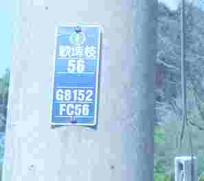
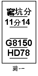
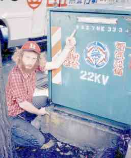
圖一 Figure 1: 視本牌 Looking at the number plate with coordinates G8150 HD78 (呼之 call this GPPQQRSTU[VW]).
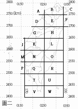
G  is a 80 × 50 km rectangle 如圖二 see figure 2.
PP increments by 1, every 800 m eastward,  00-99
QQ increments by 1, every 500 m northward, 00-99
R  increments by 1, every 100 m eastward,  A=0...H=7
S  increments by 1, every 100 m northward, A=0...E=4
T  increments by 1, every 10  m eastward,  0-9
U  increments by 1, every 10  m northward. 0-9
設備密集都市中也有 In equipment-dense cities often there are additionally:
V increments by 1, every 1 m eastward,  0-9
W increments by 1, every 1 m northward, 0-9
我們首先看看台電公司電線杆的牌子,該牌子的下兩行就是座標,經過簡單的換算,我們可以將牌子上座標換算成橫麥卡脫投影2度TM座標TWD67,這是台灣地圖常見座標系統之一,勿混淆。 以下簡單的分析電力座標所分別代表的意義。
Let's take a deeper look at that TaiPower pole number plate. Again, the last two lines of that plate, G8150 HD78, are the coordinates. We can convert them to TM-2 coordinates, version TWD67, one of the common systems found on Taiwan maps, don't confuse them. Let's take a look at the meaning of each of those numbers.
A-Z 區 areas
圖二: 以東西寬八十公里,南北長五十公里為範圍,將台灣劃分區域並以英文字母代表所在位置大區域,如台中縣東勢鎮位置為G大區。
Figure 2. As we see, TaiPower has divided Taiwan into 80 km wide, 50 km tall lettered rectangular sectors. For instance, Taizhong County, Dongshi Township, which lies in the G sector.
他區 Other areas:
- I: 無陸地 underwater
- S: 馬祖 Mazu
- U: 只有約30公頃面積 only about 30 hectares
- X, Y: 澎湖 Penghu
- Z: 金門 Jinmen
800×500m
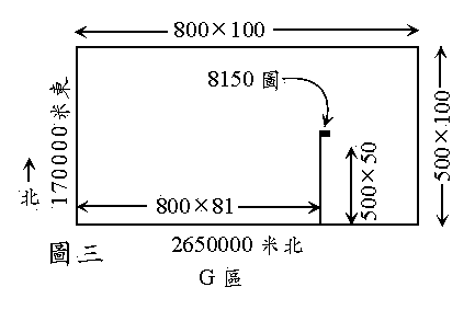
圖三:G大區共分為一萬個 配電圖圖號,每張圖東西寬800公尺,南北長500公尺。G大區最西側的X座標為170000公尺東,最南側的Y座標為2650000公尺北,而G大區第8150圖區西側之X座標為170000+81*800=234800公尺,南側之Y座標為2650000+50*500=2675000公尺,這就是電力座標G8150所代表的意義。
Figure 3. This G sector is divided up into 10000 charts back at the electric company office. Each covers 800 * 500 meters. The west edge of sector G is at x=170000 meters East. The south edge is at y=2650000 meters North. The west edge of the 8150th chart is at x=170000mE+81*800m=234800mE, the south edge is at y=2650000mN+50*500m=2675000mN. Now we understand the meaning of G8150.
100×100m
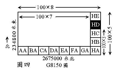
圖四:另G大區第8150號圖又細分東西ABCDEFGH各100公尺,南北ABCDE各100公尺,電力座標HD所代表範圍的西南角即距G區第8150圖西側700公尺,南側300公尺的位置。(註:A=0,B=100,C=200...)
Figure 4. This 8150th sector is further given ABCDEFGH grids, going west to east, each 100 meters apart; ABCDE grids south to north, each 100 meters apart.
As can be seen, TaiPower grid HD area's southwest corner lies 700 meters east of the west edge of box 8150, and lies 300 meters north of the south edge of box 8150. Note, A=0, B=100, C=200...
10×10m
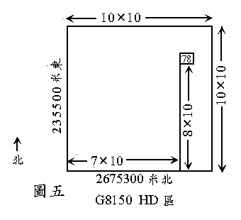
圖五:座標78所代表範圍的西南角即HD區西側往東7*10公尺,其南側往北8*10公尺。
Figure 5. Next, the "78" portion of the grid has its southwest corner at 7*10=70 meters east of the west edge of area HD, and 8*10=80 meters north of the south edge of HD.
總合 Summing up
綜合以上敘述,電力座標G8150 HD78的2度TM座標分別為
Summing up the above, power co. pole/box grid number G8150 HD78's TM-2 grid value is:
 170000+81*800+(8-1)*100+7*10 =  235570 meters East  米東
2650000+50*500+(4-1)*100+8*10 = 2675380 meters North 米北
所細分圖區雖然還是10*10公尺大的區域,可是對於出外的遊客而言,已經可以精準的得知自 己目前所在的位置。
The smallest unit of our grid is still a 10*10 meter square, but that ought to be small enough for, say, a traveler to find his spot on maps.
1×1m
在都市地區,因電線杆∕箱的密度較高,我們還可找到加印個位數字的,第一 數字:米東,第二:米北;例:G8150 HD7812。其精度則達一米,比單 一GPS衛星定位儀測出的座標值還準確(另外,電杆∕箱密的地方,房子也高,此時GPS更難 發揮功效了)。
In cities, where electrical line density is high, we can often find box and pole labels with an additional two digits, e.g. G8150 HD7812, which means add 1 meter east and 2 meters north to the above result. Indeed, the dense part of cities have tall buildings, hindering Global Positioning System (GPS) reception, so with one meter accuracy, it seems we do better than the basic hand held GPS in this case…
400x250 圖 maps
田野中偶而會發現些如: Occasionally in the field one may run across coordinates like:
- Q5322A BD04 (A)
- S7194B ED0910 (B)
多餘之一字即 400 × 250 米圖: These extra letters correspond to 400 × 250 meter maps,
+----+----+500
| A  | B  |
+----+----+250
| C  | D  |
+----+----+0
0   400  800
該多餘之一字完全能由接著之字計算: And their extra letter is merely a function of the following letters:
#!/usr/bin/perl
while (<>) {
    unless (/[A-H][A-E]\d\d/) { print "Invalid: $_"; next; }
    my $x = 0 + /[E-H][A-E]/;
    my $y = 0 + ( /[A-H][AB]/ || /[A-H]C[0-9][0-4]/ );
    my $c = chr( ord('A') + oct("0b$y$x") );
    s/ /$c /;
    print;
}
澎湖 Penghu
澎湖的 x=250000m 線為東經119度,於台灣島不同。 Penghu uses 119 east longitude as x=250000m.E., unlike Taiwan.
+------+2664000
|  X   |
|      |
+------+2614000
|  Y   |
|      |
+------+2564000
275000 355000
金門 Jinmen
金門使用UTM 6度分帶座標系統(其中央子午線為東經 117度,平移500000公尺),(本文所有縱座標均以赤道為原點)。 Jinmen uses 117 east longitude as their x=500000m.E. definition. (This is a 6 degree wide "UTM" grid area.)
金門有兩個同名為 Z 大區。因金門地小,兩 Z 區不衝突。 Jinmen has two sectors both named "Z", which don't conflict as Jinmen is small.
+------a------+2725800
|  Z   |  Z   |
|      |      |
+------+------+2675800
552700 632700 712700
Let's convert point 來換算點 "a" :
$ proj -le|grep -w intl #猜 Guessing
intl a=6378388.0 rf=297. International 1909 (Hayford)
$ echo 632700 2725800|proj -I +proj=utm +lon_0=117 +ellps=intl
118d18'40.019"E 24d38'25.43"N
至 To WGS84 見 see [1].
烏坵 Wuqiu
未知 Unknown.
馬祖 Mazu
S 區 area. 1954北京座標系, 高度採1985中國高程基準, 因此方格座標一定是Gauss-Kruger六度分帶。 討論。
例 Examples
提醒 Notices
所有我們見過的箱子有座標,但有時不但要看前面,也要看其水泥基礎。桿子有的地方舊牌無座標。
All of the switch boxes we've seen have grid numbers, but sometimes you have to look at the cement foundation, as well as the front. The poles on the other hand vary. Some districts only have older poles whose labels lack coordinates.
警告 Warnings
Taiwan datums#混淆 TWD67, TWD97 易耽誤救援 confusion can delay rescues: 台電電力座標採TWD67,非TWD97! Taiwan Power Company grid uses TWD67, not TWD97!
台電電力座標並非精確的座標系統, 原始用途為台電公司各項電力設施的財產編碼系統, 偶有偏離TWD67二度分帶座標數百公尺的案例出現, 此時請以GPS實測座標為準. 亦應參考周圍兩三桿免遇舊桿移新位仍掛舊牌之誤讀. 通報位置時也儘可能告知附近參考地標及接近路線.
Taiwan Power Company grid is not an exact system. It was intended for internal company property management. Sometimes it might be in error several hundred meters -- so then use GPS. Also beware of reused poles still bearing the labels from their former positions. Thus one should check neighboring pole labels for consistency. In any case when using it to report positions, also include names of neighboring roads, etc.
由台電內部看座標 View from inside TaiPower
台電從20年前起仿效美國,開始在配電設備上註記電力座標,截至今年初,路邊配電箱約99%標設(約20萬座),電線桿中的重點桿約15萬支標記,形同全國有35萬處設施設有電力座標,台電業務處資訊組長陳淑慧表示.(2010年3月7日自由時報)
台電電力座標為1978年由美國 Commonwealth International Inc(康瑪斯工程顧問公司)為台電公司制定一套由TWD67對應的座標系統, 總共為11個字元, p43至p45完整說明台電圖資系統.(論文:天然災害停電搶修指派作業管理系統之開發) (部份源自本 Osgeo 頁.)
正式名稱
台電座標正式名稱是"台電圖號座標"因為前五碼就是1/1200的藍曬圖圖號, 在饋線自動化電腦系統正式名稱"台電電力座標"。
轉換
台電座標是TM-2(TWD67), 市面上GPS or 導航軟體是WGS84(極近TWD97), 所以過程是: 台電座標->TWD67->WGS84(TWD97),非常準確, 誤差在10M以內, 因為台電給的通常只到10M, Ex:G3962BC34, 除非在10M內有其他設備才會定到1M內, Ex:G3962BC3437 (台中區處關連二次變電所)。
台電內部細節
先有紙本設計規劃(藍曬圖)圖號座標, 再到現場施工, 但因現場環境問題有時會移位(如民眾抗爭), 完工後又未回饋紙本就錯漏, 圖資電腦化後照紙本抄未勘誤。
通常標錯只有一個原因, 給民間包商做牌子做錯啦。 通常地上亭置噴漆的比較不會出錯, 電線桿金屬銘牌較會, 卻亦深少。
在撰寫程式初期我們發現電力座標轉TWD67後有些誤差, 但隨著台電人員的重視修正近幾年的誤差愈來越小。
台電巡修搶救人員由內部藍曬圖找出電線桿有"桿號", 人孔地下開關有"人孔號", 建物地下開關有"建物名", 以上三點在電腦統稱"桿號", 但在台電的圖或電腦上是都桿號及電力座標兩者並存, 電力座標只在"設計規劃", "施工測試"時用, 因為太長無線電傳呼時不好用。
在台電饋線調度中心(FDCC)及巡修股(或課)管理對外民眾配電系統, 就是您打 "1911" 台電接電話的單位, 在圖資未電腦化(OMS 或其他)及饋自化(DAS)是採用1/1200讀的紙本圖上面只有電線桿有"桿號" EX: 關連高幹51, 人孔地下開關有"人孔號" EX: XX路第YY孔, 建物地下開關有"建物名" EX: 台雞店南顆三廠, 為方便一律統稱"桿號"
圖資電腦化(OMS or other)及饋自化(DAS)定義資料結構桿號不夠嚴謹, 所以以電力座標定義, 資料結構嚴謹又可找出實施位置在 "設計規劃", "施工測試"時用電力座標, 但電腦化後調度(值班)人員在指揮調度現場搶修人車以無線電呼叫時電力座標反成累贅(ABCD1234很難念易搞混, 台電未用軍事通信讀音 (A: alpha, B: Bravo, C: Charlie, 么: 1, 兩: 2…), 用桿號反而方便。
現場設備只有電桿有桿號(銘牌), 地下亭置建物內設備只有電力座標(噴漆或銘牌), 但在台電的圖或電腦上都是桿號及電力座標兩者並存。
官方應用
多年來,台北縣消防局等救難單位為營救山區受困民眾,常在通訊過程請災民就地尋找「電火柱仔」或電箱,報出上面的「電力座標」編號,救難單位將它轉報台電各營業區處,由台電換算出座標所在位置後,救難單位據以展開陸、空救援,屢試不爽!消防署今(2010)年起將於全國推廣「電力座標」概念,各縣市消防局勤務中心都要訓練一名種子值勤員,能透過電力座標立即換算,以利未來救難之需,民眾危急時只要找到電力座標,報出兩排英文或數字編號給救難單位,然後在原地待援即可。
