Difference between revisions of "Training Material for 2019 UN Open GIS Challenge 2 - Open geospatial data and software for UN SDG 16, Peace justice and open institutions"
Wiki-Banbar (talk | contribs) m |
Wiki-Banbar (talk | contribs) m |
||
| Line 1: | Line 1: | ||
== Introduction == | == Introduction == | ||
| − | United Nations (UN) have identified 17 interconnected goals to achieve a better and more sustainable future for all until the end of 2030. These Sustainable Development Goals (SDGs) range from ending poverty to ensuring gender equality. In order to address most of these goals, it is imperative to have a better understanding of geographic information science and technology, as any ‘event’ has a particular geographic location. The aim of this educational tutorial is to investigate the use of Free and Open Source Software (FOSS) to address SDG 16: ‘Peace, Justice and Open Institutions’. | + | United Nations (UN) have identified 17 interconnected goals to achieve a better and more sustainable future for all until the end of 2030. These Sustainable Development Goals (SDGs) range from ending poverty to ensuring gender equality. In order to address most of these goals, it is imperative to have a better understanding of geographic information science and technology, as any ‘event’ has a particular geographic location. The aim of this educational tutorial is to investigate the use of Free and Open Source Software (FOSS) to address [https://sustainabledevelopment.un.org/sdg16/ SDG 16: ‘Peace, Justice and Open Institutions’]. |
=== Scope === | === Scope === | ||
The following educational material has been drafted within the framework of the 2019 OSGeo UN Committee Educational Challenge entitled ‘Open geospatial data and software for UN SDG 16, Peace justice and open institutions’. The seventh target of SDG 16 is to ‘ensure responsive, inclusive, participatory and representative decision-making at all levels’. Consequently, UN officers and patrols might need to collect geospatial data on the field to provide quantitative measures to address this target. In that respect, we have investigated the use of QField, which is an open source mobile data collection platform that could directly be connected to QGIS. The investigated tasks include real-time editing of geographic features, recording photos and developing a web-interface to display the collected data. There are several cloud based application development platforms and this tutorial relied on [https://www.heroku.com/ Heroku] due to its support for PostgreSQL/PostGIS as well as different web programming languages. Any user could open a free account to test their ideas on Heroku. | The following educational material has been drafted within the framework of the 2019 OSGeo UN Committee Educational Challenge entitled ‘Open geospatial data and software for UN SDG 16, Peace justice and open institutions’. The seventh target of SDG 16 is to ‘ensure responsive, inclusive, participatory and representative decision-making at all levels’. Consequently, UN officers and patrols might need to collect geospatial data on the field to provide quantitative measures to address this target. In that respect, we have investigated the use of QField, which is an open source mobile data collection platform that could directly be connected to QGIS. The investigated tasks include real-time editing of geographic features, recording photos and developing a web-interface to display the collected data. There are several cloud based application development platforms and this tutorial relied on [https://www.heroku.com/ Heroku] due to its support for PostgreSQL/PostGIS as well as different web programming languages. Any user could open a free account to test their ideas on Heroku. | ||
=== Audience === | === Audience === | ||
| − | We have prepared this educational material for researchers, educators and professionals in local, regional, national or international agencies with minimal geospatial information knowledge. We assume our audience has | + | We have prepared this educational material for researchers, educators and professionals in local, regional, national or international agencies with minimal geospatial information knowledge. We assume our audience has introductory knowledge of database management systems and programming. Nevertheless, the tutorial is intended to be self-contained meaning that anyone following the steps could understand and implement what had been achieved in this tutorial. |
=== License === | === License === | ||
| − | This educational material was prepared by Berk Anbaroğlu under the mentorship of Maria Brovelli, Serena Coetzee and Timur Obukhov. In addition, İhsan Buğra Coşkun and Mohammad Almasri contributed to the development of this tutorial. We would like to thank Agit Oktay for his support regarding the development of the web interface. The material is distributed under Attribution-ShareAlike 4.0 International (CC BY-SA 4.0) license. This entitles that the users of this tutorial could share and adapt this content as long as the attribution is provided and that the same license is used upon adaptations. | + | This educational material was prepared by Berk Anbaroğlu under the mentorship of Maria Brovelli, Serena Coetzee and Timur Obukhov. In addition, İhsan Buğra Coşkun and Mohammad Almasri contributed to the development of this tutorial. We would like to thank Agit Oktay for his support regarding the development of the web interface. Last, we would like to thank Matthias Kuhn who helped us with various issues regarding QGIS and QGField, and for his suggestion to use Syncthing. The material is distributed under Attribution-ShareAlike 4.0 International (CC BY-SA 4.0) license. This entitles that the users of this tutorial could share and adapt this content as long as the attribution is provided and that the same license is used upon adaptations. |
This tutorial has been kindly supported by the [https://www.osgeo.org/foundation-news/2019-osgeo-un-committee-educational-challenge/ 2019 OSGeo UN Committee Educational Challenge]. | This tutorial has been kindly supported by the [https://www.osgeo.org/foundation-news/2019-osgeo-un-committee-educational-challenge/ 2019 OSGeo UN Committee Educational Challenge]. | ||
=== Software Used === | === Software Used === | ||
• PostgreSQL (Postgres) 11.5 is used to create the database that would store the collected data. PostGIS 2.5.3 extension is used to handle spatial data. | • PostgreSQL (Postgres) 11.5 is used to create the database that would store the collected data. PostGIS 2.5.3 extension is used to handle spatial data. | ||
| − | • QGIS 3. | + | • QGIS 3.10 is used to create the project based on the data stored in the Postgres. |
• QField 1.2.0 is used for mobile data collection and editing. | • QField 1.2.0 is used for mobile data collection and editing. | ||
| − | • | + | • [https://syncthing.net/ Syncthing] is used to synchronize collected photos. |
=== Scenario === | === Scenario === | ||
| − | The scenario | + | The scenario utilised in this tutorial is recording the location and thematic information of trees in a region. Specifically, a lecturer identifies polygons in which each student is responsible for. Thereon, students go to the field to collect the information regarding trees in that region. The scenario can easily be adopted for an operational task that necessiates mobile spatial data collection. |
===Acquired Knowledge=== | ===Acquired Knowledge=== | ||
After going through the entire educational material, one will be able to understand the process to develop a mobile geospatial data collection platform using technologies including QField, QGIS, Postgres/PostGIS and Syncthing. | After going through the entire educational material, one will be able to understand the process to develop a mobile geospatial data collection platform using technologies including QField, QGIS, Postgres/PostGIS and Syncthing. | ||
==Setting Up the Environment== | ==Setting Up the Environment== | ||
| − | This section describes the required steps to set up the development environment. In order to | + | This section describes the required steps to set up the development environment. In order to realise the steps described in subsequent sections in a smooth manner, it is recommended to follow this section. |
===Opening a Heroku Account=== | ===Opening a Heroku Account=== | ||
| − | + | A database server should be available in the web to initiate a mobile geographic data collection project. There are several solutions that offer a free solution to this. One of the platforms supporting Postgres and PostGIS is Heroku, which is a platform as a service (PaaS) that enables developers to build, run, and operate applications entirely in the cloud. Therefore, this tutorial relied on Heroku to set up the database on the cloud. | |
| + | |||
The sign up page of [https://signup.heroku.com/login?redirect-url=https%3A%2F%2Fid.heroku.com%2Foauth%2Fauthorize%3Fclient_id%3Dd2ef2b24-e72c-4adf-8506-28db2218547d%26response_type%3Dcode%26scope%3Dglobal%252Cplatform%26state%3DSFMyNTY.g3QAAAACZAAEZGF0YW0AAAAxaHR0cHM6Ly9kYXNoYm9hcmQuaGVyb2t1LmNvbS9hdXRoL2hlcm9rdS9jYWxsYmFja2QABnNpZ25lZG4GANL7onluAQ.eDiBIjGpk8wBx82K2Ej2tBwAitNPBGNQoMMDLoySy78 Heroku], as illustrated in Figure 1, requires some personal information such as name, surname and email address. | The sign up page of [https://signup.heroku.com/login?redirect-url=https%3A%2F%2Fid.heroku.com%2Foauth%2Fauthorize%3Fclient_id%3Dd2ef2b24-e72c-4adf-8506-28db2218547d%26response_type%3Dcode%26scope%3Dglobal%252Cplatform%26state%3DSFMyNTY.g3QAAAACZAAEZGF0YW0AAAAxaHR0cHM6Ly9kYXNoYm9hcmQuaGVyb2t1LmNvbS9hdXRoL2hlcm9rdS9jYWxsYmFja2QABnNpZ25lZG4GANL7onluAQ.eDiBIjGpk8wBx82K2Ej2tBwAitNPBGNQoMMDLoySy78 Heroku], as illustrated in Figure 1, requires some personal information such as name, surname and email address. | ||
<gallery> | <gallery> | ||
Revision as of 02:48, 9 February 2020
Introduction
United Nations (UN) have identified 17 interconnected goals to achieve a better and more sustainable future for all until the end of 2030. These Sustainable Development Goals (SDGs) range from ending poverty to ensuring gender equality. In order to address most of these goals, it is imperative to have a better understanding of geographic information science and technology, as any ‘event’ has a particular geographic location. The aim of this educational tutorial is to investigate the use of Free and Open Source Software (FOSS) to address SDG 16: ‘Peace, Justice and Open Institutions’.
Scope
The following educational material has been drafted within the framework of the 2019 OSGeo UN Committee Educational Challenge entitled ‘Open geospatial data and software for UN SDG 16, Peace justice and open institutions’. The seventh target of SDG 16 is to ‘ensure responsive, inclusive, participatory and representative decision-making at all levels’. Consequently, UN officers and patrols might need to collect geospatial data on the field to provide quantitative measures to address this target. In that respect, we have investigated the use of QField, which is an open source mobile data collection platform that could directly be connected to QGIS. The investigated tasks include real-time editing of geographic features, recording photos and developing a web-interface to display the collected data. There are several cloud based application development platforms and this tutorial relied on Heroku due to its support for PostgreSQL/PostGIS as well as different web programming languages. Any user could open a free account to test their ideas on Heroku.
Audience
We have prepared this educational material for researchers, educators and professionals in local, regional, national or international agencies with minimal geospatial information knowledge. We assume our audience has introductory knowledge of database management systems and programming. Nevertheless, the tutorial is intended to be self-contained meaning that anyone following the steps could understand and implement what had been achieved in this tutorial.
License
This educational material was prepared by Berk Anbaroğlu under the mentorship of Maria Brovelli, Serena Coetzee and Timur Obukhov. In addition, İhsan Buğra Coşkun and Mohammad Almasri contributed to the development of this tutorial. We would like to thank Agit Oktay for his support regarding the development of the web interface. Last, we would like to thank Matthias Kuhn who helped us with various issues regarding QGIS and QGField, and for his suggestion to use Syncthing. The material is distributed under Attribution-ShareAlike 4.0 International (CC BY-SA 4.0) license. This entitles that the users of this tutorial could share and adapt this content as long as the attribution is provided and that the same license is used upon adaptations. This tutorial has been kindly supported by the 2019 OSGeo UN Committee Educational Challenge.
Software Used
• PostgreSQL (Postgres) 11.5 is used to create the database that would store the collected data. PostGIS 2.5.3 extension is used to handle spatial data. • QGIS 3.10 is used to create the project based on the data stored in the Postgres. • QField 1.2.0 is used for mobile data collection and editing. • Syncthing is used to synchronize collected photos.
Scenario
The scenario utilised in this tutorial is recording the location and thematic information of trees in a region. Specifically, a lecturer identifies polygons in which each student is responsible for. Thereon, students go to the field to collect the information regarding trees in that region. The scenario can easily be adopted for an operational task that necessiates mobile spatial data collection.
Acquired Knowledge
After going through the entire educational material, one will be able to understand the process to develop a mobile geospatial data collection platform using technologies including QField, QGIS, Postgres/PostGIS and Syncthing.
Setting Up the Environment
This section describes the required steps to set up the development environment. In order to realise the steps described in subsequent sections in a smooth manner, it is recommended to follow this section.
Opening a Heroku Account
A database server should be available in the web to initiate a mobile geographic data collection project. There are several solutions that offer a free solution to this. One of the platforms supporting Postgres and PostGIS is Heroku, which is a platform as a service (PaaS) that enables developers to build, run, and operate applications entirely in the cloud. Therefore, this tutorial relied on Heroku to set up the database on the cloud.
The sign up page of Heroku, as illustrated in Figure 1, requires some personal information such as name, surname and email address.
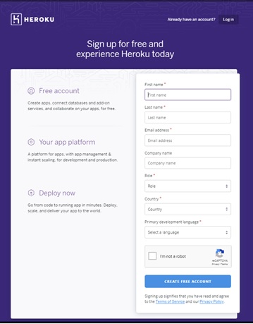
Figure 1. Sign up page of Heroku

Once the form is submitted, an email would be sent to verify the account. The user could then use this/her credentials to create a new app. Second step is to create the database as illustrated in Figure 2(a-h).