Difference between revisions of "GvSIG Report 2007"
Jump to navigation
Jump to search
m (creation of the wiki article, no content at this moment) |
m |
||
| (One intermediate revision by the same user not shown) | |||
| Line 5: | Line 5: | ||
== Key Accomplishments == | == Key Accomplishments == | ||
| − | * the | + | * Releases: |
| + | ** 1.0.1 (4 of January) | ||
| + | ** jCRS and geoBD pilots (21 and 22 of Febrary) | ||
| + | ** 1.0.2 (9 of May) | ||
| + | ** SEXTANTE 0.1 (7 of June) | ||
| + | ** Network pilot (27 of June) | ||
| + | ** 1.1.0 (21 of October) | ||
| + | ** Raster pilot (10 of December) | ||
| + | ** 1.1.1 (21 of December) | ||
| + | * gvSIG has joined the SEXTANTE project, adding to gvSIG a powerful and extensible framework to create easily raster and vectorial algorithms. Nowadays SEXTANTE adds to gvSIG almost 200 algorithms. | ||
| + | * gvSIG has been translated into many languages, and the web site is now offered in English and Chinese besides Spanish and Valencian languages. | ||
| + | * Some developers and managers presented at FOSS4G2007 in Victoria (Canada) current and near features, as the 3D extension and gvSIG for mobile devices. | ||
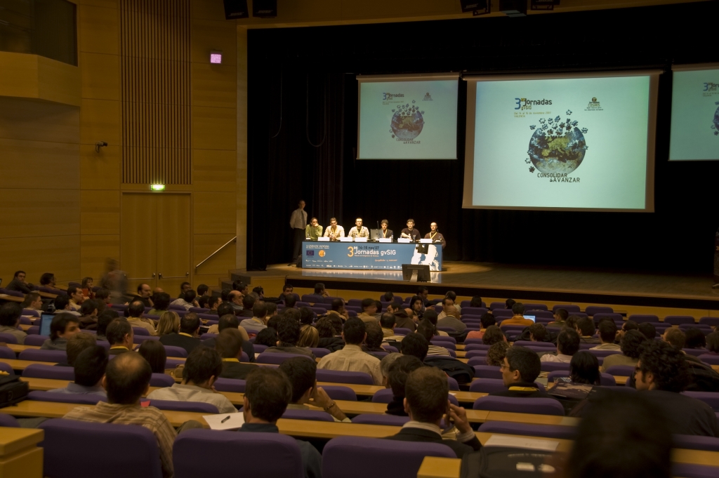
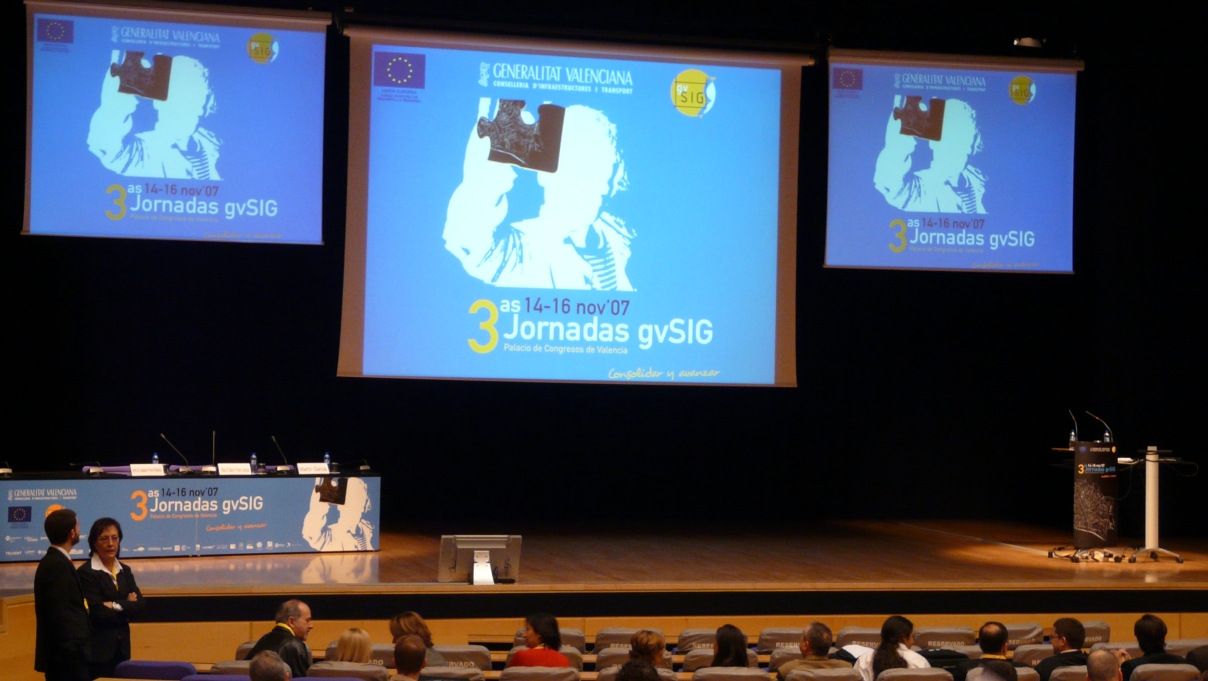
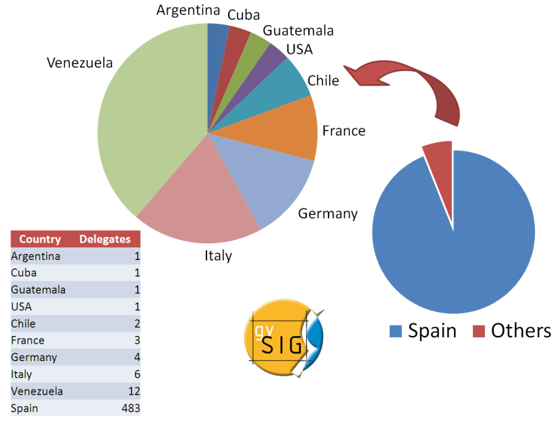
| + | * The 3rd gvSIG meeting was a succesful event, with more than 500 attendees from many countries, presenting project advances, new applications and projects using gvSIG as underlying technology as well as other FOSS4G projects like Geonetwork Open Source. | ||
| + | * gvSIG has entered into OSGeo incubation as a way to improve the relationship of the project with the community and other FOSS4G projects | ||
| + | |||
| + | [[Image:3rd_gvSIG_Meeting.jpg|frameless|450px]] | ||
| + | [[Image:3rd_gvSIG_Meeting_2.jpg|frameless|532px]] | ||
| + | |||
| + | |||
| + | [[Image:GvSIG_AR_Attendance.png|center|500px|thumb|3rd gvSIG attendance by country]] | ||
| + | |||
| + | ===Downloads=== | ||
| + | |||
| + | These are approximate numbers about gvSIG releases downloads during 2007: | ||
| + | |||
| + | {|class=wikitable | ||
| + | |- style="font-weight:bold;text-align:center;background-color:#AA4643;color:white;" | ||
| + | |Releases | ||
| + | |Downloads | ||
| + | |Pilots | ||
| + | |Downloads | ||
| + | |- | ||
| + | | 0.6 || 421 || Network || 600 | ||
| + | |- | ||
| + | |1.0 || 23.000 || Raster || 1800 | ||
| + | |- | ||
| + | |1.0.1 || 6.500 || geoDB ||1900 | ||
| + | |- | ||
| + | |1.0.2 || 11.800 || ArcIMS || 400 | ||
| + | |- | ||
| + | |1.1 || 17.700 ||jCRS || 738 | ||
| + | |- | ||
| + | |1.1.1 || 300 | ||
| + | | | ||
| + | |} | ||
== Areas for Improvement == | == Areas for Improvement == | ||
| − | * | + | * The collaborative infrastructure needs to be improved, allowing community to interact with the project in a more efficient way. |
| − | + | * The user, and specially, the developer documentation has to be on the website not only as PDFs. | |
| + | * Keep the organization more in touch with the community, giving information about the technical and organizational decisions, ongoing projects, and so on. | ||
| + | * Improve the use of the English language to foster the communication with non Spanish community. | ||
| + | * Improve the communication channels with other FOSS4G projects to find common approaches for tools, procedures, etc. | ||
| + | |||
== Opportunities to Help == | == Opportunities to Help == | ||
| − | * | + | [[Image:GvSIG_AR_Collaboration.png|500px|right|thumb|gvSIG related projects by sector and geographical scope]] |
| + | * Discuss on the mailing lists! | ||
| + | * Test and send bugs | ||
| + | * Propose new features for gvSIG | ||
| + | * Translate the application and the documentation and many other materials | ||
| + | * Write successful (or not) use cases | ||
| + | * Sponsor the gvSIG meeting | ||
| + | * Offer training with gvSIG | ||
| + | * Develope new plugins | ||
| + | |||
| + | |||
== Outlook for 2008 == | == Outlook for 2008 == | ||
| − | * | + | [[Image:GvSIG_AR_Project_Participants.png|500px|thumb|right|Number of people related with the project by year (total 457)]] |
| + | |||
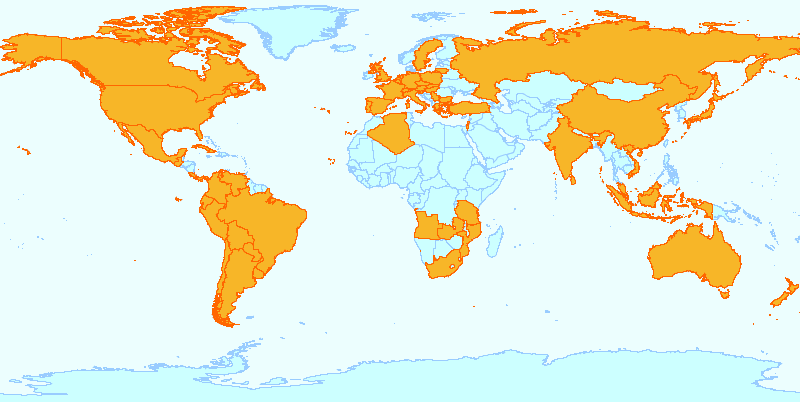
| + | [[Image:GvSIG_AR_World.png|thumb|500px|right|Known countries where gvSIG is beeing used]] | ||
| + | * Publish the new portal for the gvSIG project with: | ||
| + | ** Complete user and developer documentation (first in Spanish, later in English and other languages) | ||
| + | ** Community support (howto's, mailing lists, planet, ...) | ||
| + | ** Support for gvSIG internationalization | ||
| + | ** News and events related with gvSIG and other FOSS4G projects | ||
| + | ** Information about new gvSIG developments and releases | ||
| + | ** ... | ||
| + | * Create a new organization that will support and strength the gvSIG project | ||
| + | * Start a training program for gvSIG | ||
| + | * Publish first releases of: | ||
| + | ** 3D support | ||
| + | ** Raster and remote sensing capabilities | ||
| + | ** Metadata handling capabilities | ||
| + | ** gvSIG Mobile | ||
| + | ** Web publishing extension | ||
| + | ** New topology and geoprocessing capabilities | ||
| + | ** Advanced symbology | ||
| + | ** More SDI integration: WPS client | ||
| + | ** Advanced editing | ||
| + | * Start working on new features: | ||
| + | ** 4D support | ||
| + | ** Geostatistics | ||
| + | ** Surveying | ||
| + | ** Sensor web | ||
| − | [[Category: Reports 2007]] | + | [[Category: Reports 2007]] [[Category:gvSIG]] |
Latest revision as of 03:11, 18 February 2008
gvSIG Annual Report
- Period covered by report: Jan-Dec 2007
- Contact name: Jorge Sanz
Key Accomplishments
- Releases:
- 1.0.1 (4 of January)
- jCRS and geoBD pilots (21 and 22 of Febrary)
- 1.0.2 (9 of May)
- SEXTANTE 0.1 (7 of June)
- Network pilot (27 of June)
- 1.1.0 (21 of October)
- Raster pilot (10 of December)
- 1.1.1 (21 of December)
- gvSIG has joined the SEXTANTE project, adding to gvSIG a powerful and extensible framework to create easily raster and vectorial algorithms. Nowadays SEXTANTE adds to gvSIG almost 200 algorithms.
- gvSIG has been translated into many languages, and the web site is now offered in English and Chinese besides Spanish and Valencian languages.
- Some developers and managers presented at FOSS4G2007 in Victoria (Canada) current and near features, as the 3D extension and gvSIG for mobile devices.
- The 3rd gvSIG meeting was a succesful event, with more than 500 attendees from many countries, presenting project advances, new applications and projects using gvSIG as underlying technology as well as other FOSS4G projects like Geonetwork Open Source.
- gvSIG has entered into OSGeo incubation as a way to improve the relationship of the project with the community and other FOSS4G projects
Downloads
These are approximate numbers about gvSIG releases downloads during 2007:
| Releases | Downloads | Pilots | Downloads |
| 0.6 | 421 | Network | 600 |
| 1.0 | 23.000 | Raster | 1800 |
| 1.0.1 | 6.500 | geoDB | 1900 |
| 1.0.2 | 11.800 | ArcIMS | 400 |
| 1.1 | 17.700 | jCRS | 738 |
| 1.1.1 | 300 |
Areas for Improvement
- The collaborative infrastructure needs to be improved, allowing community to interact with the project in a more efficient way.
- The user, and specially, the developer documentation has to be on the website not only as PDFs.
- Keep the organization more in touch with the community, giving information about the technical and organizational decisions, ongoing projects, and so on.
- Improve the use of the English language to foster the communication with non Spanish community.
- Improve the communication channels with other FOSS4G projects to find common approaches for tools, procedures, etc.
Opportunities to Help
- Discuss on the mailing lists!
- Test and send bugs
- Propose new features for gvSIG
- Translate the application and the documentation and many other materials
- Write successful (or not) use cases
- Sponsor the gvSIG meeting
- Offer training with gvSIG
- Develope new plugins
Outlook for 2008
- Publish the new portal for the gvSIG project with:
- Complete user and developer documentation (first in Spanish, later in English and other languages)
- Community support (howto's, mailing lists, planet, ...)
- Support for gvSIG internationalization
- News and events related with gvSIG and other FOSS4G projects
- Information about new gvSIG developments and releases
- ...
- Create a new organization that will support and strength the gvSIG project
- Start a training program for gvSIG
- Publish first releases of:
- 3D support
- Raster and remote sensing capabilities
- Metadata handling capabilities
- gvSIG Mobile
- Web publishing extension
- New topology and geoprocessing capabilities
- Advanced symbology
- More SDI integration: WPS client
- Advanced editing
- Start working on new features:
- 4D support
- Geostatistics
- Surveying
- Sensor web
