Difference between revisions of "Angelos Tzotsos"
Jump to navigation
Jump to search
| Line 12: | Line 12: | ||
[[File:OSGeo_charter.png|link=OSGeo_Advocate#OSGeo_Charter_Members]] [[File:OSGeo_coder.png|link=OSGeo_Advocate#Developers_and_Committee_Members]] [[File:OSGeo_translate.png|link=OSGeo_Advocate#OSGeo Translators]] | [[File:OSGeo_charter.png|link=OSGeo_Advocate#OSGeo_Charter_Members]] [[File:OSGeo_coder.png|link=OSGeo_Advocate#Developers_and_Committee_Members]] [[File:OSGeo_translate.png|link=OSGeo_Advocate#OSGeo Translators]] | ||
: | : | ||
| − | :* [http://live.osgeo.org OSGeoLive]. Build manager and developer | + | :* [http://live.osgeo.org OSGeoLive]. Build manager and developer. |
| − | :* [http://pycsw.org pycsw]. Developer | + | :* [http://pycsw.org pycsw]. Core Developer. |
:* [http://zoo-project.org zoo-project]. Contributor of linux packages and documentation. Currently core developer. | :* [http://zoo-project.org zoo-project]. Contributor of linux packages and documentation. Currently core developer. | ||
| − | :* [http://orfeo-toolbox.org/otb/ Orfeo Toolbox]. | + | :* [http://orfeo-toolbox.org/otb/ Orfeo Toolbox]. Developer. |
| + | :* [http://geonode.org GeoNode]. Core Developer. | ||
| + | :* [https://github.com/kalxas/gnorasi Gnorasi]. Core Developer. | ||
:* [http://owslib.sourceforge.net/ OWSlib]. Patch contributor. | :* [http://owslib.sourceforge.net/ OWSlib]. Patch contributor. | ||
:* [http://sourceforge.net/projects/mseg MSEG]. Personal project | :* [http://sourceforge.net/projects/mseg MSEG]. Personal project | ||
:* [http://sourceforge.net/projects/gimed GIMED]. Personal project | :* [http://sourceforge.net/projects/gimed GIMED]. Personal project | ||
| − | :* [http://www.opensuse.org openSUSE] official member and | + | :* [http://www.opensuse.org openSUSE] official member and geospatial package maintainer in openSUSE:Factory (Application:Geo). |
:* OSGeoLive presentations in 3 conferences: [http://www.geodata.gov.gr/geodatacamp/mediawiki/index.php/GeoDataCamp2010 GeoDataCamp2010]([http://www.geodata.gov.gr/geodatacamp/mediawiki/images/c/cc/GeoDataCamp2010_GEOFOSS_OSGeoLive.pdf pdf],[http://www.geodata.gov.gr/geodatacamp/mediawiki/index.php/File:2010-11-19_11-45-39_624.jpg image]), [http://www.hellasgi.gr/ HellasGI 2012] ([http://aiolos.survey.ntua.gr/slides/hellasgi2012/ slides]), [http://serres.fosscomm.gr/?page_id=582 FOSSCOMM 2012] ([http://t.co/o6I6IbGq video],[http://aiolos.survey.ntua.gr/slides/fosscom2012/ slides]) | :* OSGeoLive presentations in 3 conferences: [http://www.geodata.gov.gr/geodatacamp/mediawiki/index.php/GeoDataCamp2010 GeoDataCamp2010]([http://www.geodata.gov.gr/geodatacamp/mediawiki/images/c/cc/GeoDataCamp2010_GEOFOSS_OSGeoLive.pdf pdf],[http://www.geodata.gov.gr/geodatacamp/mediawiki/index.php/File:2010-11-19_11-45-39_624.jpg image]), [http://www.hellasgi.gr/ HellasGI 2012] ([http://aiolos.survey.ntua.gr/slides/hellasgi2012/ slides]), [http://serres.fosscomm.gr/?page_id=582 FOSSCOMM 2012] ([http://t.co/o6I6IbGq video],[http://aiolos.survey.ntua.gr/slides/fosscom2012/ slides]) | ||
:* Geospatial Open Source Software presentations: [http://www.geodata.gov.gr/geodatacamp/mediawiki/images/b/b9/GeoDataCamp2010_Metadata_GIMED.pdf GIMED metadata editor] and [http://www.geodata.gov.gr/geodatacamp/mediawiki/images/5/5d/GeoDataCamp2010_Metadata_Intro.pdf INSPIRE metadata specifications] at [http://www.geodata.gov.gr/geodatacamp/mediawiki/index.php/GeoDataCamp2010 GeoDataCamp2010], [http://www.asprs.org/publications/proceedings/reno2006/0159.pdf MSEG] at [http://www.asprs.org/Conference-Proceedings/ASPRS-Reno-2006-Conference-Proceedings.html ASPRS 2006]. | :* Geospatial Open Source Software presentations: [http://www.geodata.gov.gr/geodatacamp/mediawiki/images/b/b9/GeoDataCamp2010_Metadata_GIMED.pdf GIMED metadata editor] and [http://www.geodata.gov.gr/geodatacamp/mediawiki/images/5/5d/GeoDataCamp2010_Metadata_Intro.pdf INSPIRE metadata specifications] at [http://www.geodata.gov.gr/geodatacamp/mediawiki/index.php/GeoDataCamp2010 GeoDataCamp2010], [http://www.asprs.org/publications/proceedings/reno2006/0159.pdf MSEG] at [http://www.asprs.org/Conference-Proceedings/ASPRS-Reno-2006-Conference-Proceedings.html ASPRS 2006]. | ||
Revision as of 01:31, 13 June 2013
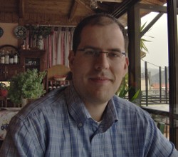
Angelos Tzotsos
Researcher, Remote Sensing Laboratory, NTUA
Location: Athens, Greece
Angelos is a remote sensing expert with background in surveying engineering and software development. He is involved in numerous activities around free and open source software and has great experience in geospatial applications. His research involves object-based image analysis, machine learning, computer vision and remote sensing. He is an active advocate of OSGeo in Greece at related conferences.... more.
- OSGeo Experience
-
- OSGeoLive. Build manager and developer.
- pycsw. Core Developer.
- zoo-project. Contributor of linux packages and documentation. Currently core developer.
- Orfeo Toolbox. Developer.
- GeoNode. Core Developer.
- Gnorasi. Core Developer.
- OWSlib. Patch contributor.
- MSEG. Personal project
- GIMED. Personal project
- openSUSE official member and geospatial package maintainer in openSUSE:Factory (Application:Geo).
- OSGeoLive presentations in 3 conferences: GeoDataCamp2010(pdf,image), HellasGI 2012 (slides), FOSSCOMM 2012 (video,slides)
- Geospatial Open Source Software presentations: GIMED metadata editor and INSPIRE metadata specifications at GeoDataCamp2010, MSEG at ASPRS 2006.
- Contact
- Email: tzotsos AT gmail DOT com
- Email: gcpp.kalxas AT gmail DOT com
- Phone (mobile): +30 693 2149344
- Spoken Language(s)
- Greek, English
- Profile last updated
- 9 July 2012
{{#umSetParam: 37.9790|23.7676|Athens, Greece|Kalxas|Angelos Tzotsos}}
