Difference between revisions of "GvSIG GSoC 2012 Ideas"
| Line 31: | Line 31: | ||
|} | |} | ||
| − | === Suggested simplest version === | + | ==== Suggested simplest version ==== |
* There will be a ''Start Survey'' button which will create an in-memory vector layer in gvSIG Mini using its geometry model (this has nothing to do with the output format yet). | * There will be a ''Start Survey'' button which will create an in-memory vector layer in gvSIG Mini using its geometry model (this has nothing to do with the output format yet). | ||
| Line 47: | Line 47: | ||
In this simplest version, gvSIG Mini will write a vector data file but will not necessarily be able to read it. If you choose SHP as the output format, you might use the shapefile writer available in gvSIG and gvSIG Mobile or use some other GIS library to perform the export operation (GeoTools, etc). | In this simplest version, gvSIG Mini will write a vector data file but will not necessarily be able to read it. If you choose SHP as the output format, you might use the shapefile writer available in gvSIG and gvSIG Mobile or use some other GIS library to perform the export operation (GeoTools, etc). | ||
| − | === Suggested improvements === | + | ==== Suggested improvements ==== |
* Implement also the import option to let the user open the resulting vector data file. | * Implement also the import option to let the user open the resulting vector data file. | ||
Revision as of 06:36, 10 March 2012
Use this page to jot down and develop any good idea for the Google Summer of Code 2012 program with gvSIG project. Please, use the gvSIG mailing lists for discussion and check 2011, 2010, 2009 ideas pages for examples or reference.
Create a gvSIG plugin for drinking water analysis and management.
- Product: gvSIG Desktop
- Possible mentor: Francisco José Peñarrubia
- Possible student: if applicable
The analysis part will be done with Epanet's help (http://www.epa.gov/nrmrl/wswrd/dw/epanet.html).
The idea is to define a layer model suitable to be exported to Epanet's .inp file, and a geoprocess to export this model to Epanet. So, we will need to define pipes, wells, valves, depots and so on in gvSIG, analize connectivity and test data integrity (with Network Analysis Extension) and then export to Epanet.
From Epanet, the user will be able to analyze and modify the network and then export the network again to gvSIG.
So, the main tasks are: Define layer model , Create a geoprocess exporter to .INP (we can start from an ongoing work) , Create a geoprocess importer back to gvSIG.
After having the network already balanced in gvSIG, we will develop some methods in order to manage the daily operation of the network. (See possible leaks, see wich pipes or valves need to be replaced, etc).
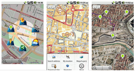
Adding GPS survey capabilities to gvSIG Mini
- Product: gvSIG Mini
- Possible mentor: <Enter your name here>
- Possible student: <Enter your name here>

|
Storing GPS coordinates in a well-known vector format is a powerful professional-oriented feature, currently unavailable in gvSIG Mini. The suggested output format is SHP due to its popularity. |
Suggested simplest version
- There will be a Start Survey button which will create an in-memory vector layer in gvSIG Mini using its geometry model (this has nothing to do with the output format yet).
- At any moment, the user will be able to push an Export button to create a vector data file in the device's SD card with the current set of coordinates. The suggested output format is ESRI Shapefile. Alternatives: GML, GPX, Sqlite, GeoJSon, etc.
- It is also important to let the user associate some values to each feature (attributes). In order to establish the attribute names and types and perhaps valid values, you could simply use a properties file (attributes.properties) so the implementation will be easier. I'm thinking about something like:
ELEMENT=STRING;TREE,ROCK,HOLE,POOL
SIZE=STRING;LARGE,MEDIUM,SMALL
COMMENT=STRING
- The geometry type will be POINT to make the implementation easier.
In this simplest version, gvSIG Mini will write a vector data file but will not necessarily be able to read it. If you choose SHP as the output format, you might use the shapefile writer available in gvSIG and gvSIG Mobile or use some other GIS library to perform the export operation (GeoTools, etc).
Suggested improvements
- Implement also the import option to let the user open the resulting vector data file.
- Let the user choose LINE or POLYGON as the geometry type of the new vector layer. This will make the application more sophisticated, as it will be necessary to think about a user-friendly way to finish the current feature and start a new one.
Idea template
- Product: gvSIG Desktop/gvSIG Mobile/gvSIG Mini
- Possible mentor: if applicable
- Possible student: if applicable
Write your idea here... Lorem ipsum dolor sit amet, consectetur adipiscing elit. Morbi imperdiet condimentum leo sit amet scelerisque. Aliquam placerat, dolor non egestas gravida, tellus felis viverra dui, a scelerisque dolor leo in nulla. Suspendisse pharetra lacus vitae lacus mollis dapibus dignissim metus varius. Nullam scelerisque, elit sit amet ornare commodo, tortor enim consectetur est, eget imperdiet leo augue eget felis. Vivamus nec justo tellus, nec semper ante. Etiam et dolor urna. Nullam non augue in lacus auctor laoreet eget non erat. Integer id justo id magna commodo malesuada. Maecenas tincidunt ipsum nec erat fringilla posuere. Sed ante sapien, posuere non euismod tincidunt, fermentum sollicitudin quam. Aenean metus lacus, viverra ut hendrerit eu, interdum vitae turpis.