Difference between revisions of "OpenLayers Tutorial Pt"
| Line 36: | Line 36: | ||
== "Olá Mundo" OpenLayers == | == "Olá Mundo" OpenLayers == | ||
| + | |||
| + | http://openlayers.org/doc/ | ||
Revision as of 10:04, 28 September 2008

Introdução
OpenLayers é uma biblioteca JavaScript open-source, sob licença BSD, que permite construir páginas web contendo informação geo-espacial dinâmica e independente de servidor. Implementa uma API JavaSript, ainda em desenvolvimento, que permite a construção de aplicações geográficas web-based, disponilbilizando APIs como o Google Maps e o MSN Virtual Earth, desta feita, como software livre. Criado pela MetaCarta, que continua a desempenhar um papel activo no suporte e gestão deste projecto, pertence desde de Novembro de 2007 à Open Source Geospatial Foundation que apoia e promove o desenvolvimento cooperativo de tecnologias e dados geo-espaciais.
Antes de começar
Before Getting Started -- The Technologies Behind <a class="wiki" href="/wiki/OpenLayers">OpenLayers</a><a title="Link to this section" class="anchor" href="/wiki/Documentation#BeforeGettingStarted--TheTechnologiesBehindOpenLayers"> ¶</a>
We at OpenLayers generally assume that everyone who comes to us is already a highly skilled web programmer. Such, however, is not always the case. Here we have assembled a few quick links to tutorials and the like on how to master the art of coding in JavaScript, debug in Firebug, understand JSON, etc.
- <a class="ext-link" href="http://blog.mootools.net/2007/6/5/help-i-dont-know-javascript">Introduction to JavaScript</a> by the people at <a class="ext-link" href="http://mootools.net">mootools</a>.
- Four-part video series by <a class="ext-link" href="http://www.crockford.com/">Douglas Crockford</a> on <a class="ext-link" href="http://video.yahoo.com/watch/111593/1710507">Programming in JavaScript</a>
- <a class="ext-link" href="http://javascript.crockford.com/">Crockford's JavaScript page</a>
- <a class="ext-link" href="http://www.json.org/">Introduction to JSON</a>
- <a class="ext-link" href="http://getfirebug.com/logging.html">Debugging with Firebug
Para Programadores
OpenLayers is a pure JavaScript library for displaying map data in most modern web browsers, with no server-side dependencies. OpenLayers implements a (still-developing) JavaScript API for building rich web-based geographic applications, similar to the Google Maps and MSN Virtual Earth APIs, with one important difference -- OpenLayers is Free Software, developed for and by the Open Source software community.
OpenLayers is becoming a project of the Open Source Geospatial Foundation.
Furthermore, OpenLayers implements industry-standard methods for geographic data access, such as the OpenGIS Consortium's Web Mapping Service (WMS) and Web Feature Service (WFS) protocols. Under the hood, OpenLayers is written in object-oriented JavaScript, using components from Prototype.js and the Rico library. The OpenLayers code base already has hundreds of unit tests, via the Test.AnotherWay framework.
As a framework, OpenLayers is intended to separate map tools from map data so that all the tools can operate on all the data sources. This separation breaks the proprietary silos that earlier GIS revolutions have taught civilization to avoid. The mapping revolution on the public Web should benefit from the experience of history.
"Olá Mundo" OpenLayers
Map e Layer são dois conceitos importantes na construção de um mapa com o API OpenLayers. Um Map guarda informação acerca do mapa: projecção base, extensão, unidades, etc.Dentro do Map a informação é disponibilizada via Layer's, que sendo a fonte de informação, define como esta deve ser requerida e apresentada.
O OpenLayers suporta a inserção de mapas em quase todas as tags html de tipo block-level, (como por exemplo TODO)
Para construir um visualizador OpenLayers numa página web, basta inseri-lo numa tag deste tipo
incluindo uma tag script para incluir a biblioteca OpenLayers no código da página html.
    <html>
    <head>
      <title>OpenLayers Example</title>

        <script src="http://openlayers.org/api/OpenLayers.js"></script>
    </head>
    <body>
          <div style="width:100%; height:100%" id="map"></div>
Cria-se o Map através do construtor OpenLaer.Map, que tem como o argumento o elemento HTML onde estará contido ou o seu IDvar map = new OpenLayers.Map('map');
O OpenLayers suporta vários data sources, WMS, Yahoo! Maps, WorldWind e etc.Neste exemplo utiliza-se como Map um WMS da MetaCarta.
Para adicionar uma Layer ao Map, o construtor do Layer tem como parametros a URL do WMS server usado, e um objecto que contem os parametros a serem anexados ao pedido WMS.
    var wms = new OpenLayers.Layer.WMS(
        "http://labs.metacarta.com/wms/vmap0",
        {'layers':'basic'} );
    map.addLayer(wms);
Para apresentar o mapa é preciso definir o center e zoom level.
A função 'zoomToMaxExtent' permite fazer com que o mapa encaixe no tamanho da janela com o maior zoom possível.
Juntando todas as partes:
<html>
    <head>
      <title>OpenLayers Example</title>
        <script
        src="http://openlayers.org/api/OpenLayers.js"></script>
        </head>
        <body>
          <div style="width:100%; height:100%" id="map"></div>
          <script defer="defer" type="text/javascript">
            var map = new OpenLayers.Map('map');
            var wms = new OpenLayers.Layer.WMS( "OpenLayers WMS",
                "http://labs.metacarta.com/wms/vmap0", {layers: 'basic'} );
            map.addLayer(wms);
            map.zoomToMaxExtent();
          </script>
    </body>
    </html>
Tem-se o código HTML para vizualizar o primeiro Mapa.
Exemplos, passo a passo
Neste secção, vamos demonstrar alguns exemplos de como utilizar algumas das funcionalidades do OpenLayers.
- Utilizar o OpenLayers numa página Web, é simples e fácil. Para tal, basta incluir o seguinte código na página:
<iframe
      src="http://openlayers.org/viewer/"
      width="400" height="200"
      scrolling="no"
      marginwidth="0" marginheight="0"
      frameborder="0">
 </iframe>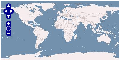
- Para especificar, por exemplo, as coordenadas de latitude e longitude e o nível de zoom, utiliza-se os parâmetros URL, Center e Zoom:
<iframe
      src="http://openlayers.org/viewer/?center=39.5,-7&zoom=6"
      width="100%" height="300"
      scrolling="no"
      marginwidth="0" marginheight="0"
      frameborder="0">
</iframe>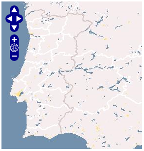
Estes exemplos utilizam mapas, recebendo-os dinamicamente de um servidor WMS.
Guia de Utilização
http://trac.openlayers.org/wiki/UserGuide
Adicionar um Overlay WMS
As Layers WMS tem a capacidade de sobrepor outras Layers WMS numa mesma projecção, definindo-se para tal como um Overlay.
Isto pode ser feito de diversas maneiras. Definir o parametro transparent como true é a melhor opção no caso WMS.
Como adicionar um Overlay WMS transparente a um Map.
        var twms = new OpenLayers.Layer.WMS( "World Map",

            "http://world.freemap.in/cgi-bin/mapserv?",

            { map: '/www/freemap.in/world/map/factbooktrans.map',

              transparent: 'true', layers: 'factbook',

              format: 'png'} );

        map.addLayer(twms);
--->>>> imggtngstrtd2
Google Maps
Para criar um Google Map no OpenLayers é necessário incluir uma tag script Google Maps para o dominio em questão,
especificando a respectiva chave da Google Maps API.
Example script URL for Google Maps
      <script src="http://maps.google.com/maps?file=api&v=2&key=YourKey"
            type="text/javascript"></script>
Uma vez incluída a esta tag, basta adicionar um novo tipo de Layer ao Map:
Creating a Hybrid Map, and adding it to the map
      var google = new OpenLayers.Layer.Google( "Google", { type: G_HYBRID_MAP } );

      map.addLayer(google);
Neste exemplo é utilizado um mapa do tipo G_HYBRID_MAP, o G_SATELLITE_MAP também é suportado.
--->>>> imggtngstrtd1Funcionalidades Avançadas
Exemplo de uma app já com muita cena :)
Fornecedores de Serviços
Features:
- Load map data from many sources:
Outros Recursos
http://dev.openlayers.org/apidocs/index/General.html
Before Getting Started -- The Technologies Behind OpenLayers
We at !OpenLayers generally assume that everyone who comes to us is already a highly skilled web programmer. Such, however, is not always the case. Here we have assembled a few quick links to tutorials and the like on how to master the art of coding in !JavaScript, debug in Firebug, understand JSON, etc.
* Introduction to JavaScript by the people at mootools.
* Four-part video series by Douglas Crockford on Programming in JavaScript
* Crockford's JavaScript page
* Introduction to JSON
* Debugging with Firebug
Obter o Código
Getting the Code
Releases are made available on the downloads page. Additionally, if you wish to use OpenLayers in a web application, you can include http://www.openlayers.org/api/OpenLayers.js in your page, to always get the latest release.
The code is also available in our Subversion repository. Using Subversion, you can keep up to the absolute bleeding edge of the code. If you wish to report a bug in the API, and you are able to use Subversion, please see if the bug has been fixed in Subversion first: OpenLayers is under rapid development, so things change quickly.
If you don't have Subversion or don't want to download the code, you can still try some live examples on openlayers.org. If you're familiar with JavaScript, try viewing the source of the examples to get an idea how the OpenLayers library is used.
OpenLayers is still undergoing rapid development, so expect a lot to change in the next few weeks and months. We need your support! Please check the wiki for the very latest updates and documentation, and thank you for taking an interest.
Downloading OpenLayers<a title="Link to this section" class="anchor" href="/wiki/HowToDownload#DownloadingOpenLayers"> ¶</a>Current Stable API URL is always <a href="http://openlayers.org/api/OpenLayers.js">http://openlayers.org/api/OpenLayers.js</a>
Current Version API URL is <a href="http://openlayers.org/api/2.6/OpenLayers.js">http://openlayers.org/api/2.6/OpenLayers.js</a>
Latest stable release: [<a href="http://openlayers.org/download/OpenLayers-2.6.tar.gz">.tar.gz</a>] [<a href="http://openlayers.org/download/OpenLayers-2.6.zip">.zip</a>]
[<a href="http://openlayers.org/download/OpenLayers-2.6-withdocs.tar.gz">.tar.gz with docs</a>] [<a href="http://openlayers.org/download/OpenLayers-2.6-withdocs.zip">.zip with docs</a>]
Older releases: <a href="http://openlayers.org/download/">http://openlayers.org/download/</a>
Getting the Development Version From SVN<a title="Link to this section" class="anchor" href="/wiki/HowToDownload#GettingtheDevelopmentVersionFromSVN"> ¶</a>
If you have <a class="ext-link" href="http://subversion.tigris.org/">SVN</a> you can simply checkout the latest OpenLayers code base. To get OpenLayers using SVN, simply type the following from your nearest commandline:
svn checkout http://svn.openlayers.org/trunk/openlayers/
The repository is world readable. Write access is limited. If you want to contribute code, send a patch to the list. We'll grant committer access to frequent contributors.
To get the latest build, download or link to the <a class="ext-link" href="http://dev.openlayers.org/nightly/OpenLayers.js">OpenLayers.js nightly</a>.
You can also browse the code by clicking the <a href="/browser/trunk/openlayers/">Browse Source</a> button on the toolbar above.

