Difference between revisions of "Openlayers: las herramientas disponibles por defecto"
| Line 12: | Line 12: | ||
[[Image:Openlayers controls overview.png|thumb|none|400px|Una vista de todos los principale Controls de Openlayers]] | [[Image:Openlayers controls overview.png|thumb|none|400px|Una vista de todos los principale Controls de Openlayers]] | ||
| + | <pre> | ||
| + | OpenLayers.Control: | ||
| + | Operating elements in OpenLayers are elements related to map navigation as well the display of map information (e.g. scale). The Control class serves as a base class for all operating elements, among them: | ||
| + | OpenLayers.Control.PanZoom | ||
| + | generates pan/zoom navigation with a panning pad (4 arrow buttons), as well as a ZoomIn, ZoomOut, and ZoomReset button. The slideFactor parameter defines the number of pixels used during the panning processes. | ||
| + | |||
| + | OpenLayers.Control.PanZoomBar | ||
| + | generates a pan/zoom bar with a pan navigation panel as well as a zoombar with a zoom slider containing a ZoomIn and ZoomOut button at each end. (see Section 2.3.4). | ||
| + | The zoom bar is integral to the development of animated zooming features. For this reason its functionality is described in more detail. | ||
| + | There are three ways to use the zoom bar: | ||
| + | |||
| + | 1. Click on the + or - button located at each end of the zoom bar. | ||
| + | This results in an increase/decrease of the map view by one zoom level. | ||
| + | 2. Click anywhere on the zoom bar. | ||
| + | The slider moves to the nearest predefined zoom level. The map is redrawn to the corresponding zoom level. | ||
| + | 3. Use Drag&Drop to move zoom slider smoothly over the zoom bar. | ||
| + | Upon releasing the left mouse key, the slider positions itself on the next available zoom level, and the selected map view is redrawn to the corresponding zoom level. | ||
| + | |||
| + | OpenLayers.Control.OverviewMap | ||
| + | generates a small overview map (see Section 2.3.4). This map shows the current view of the main map and serves as a positioning and navigational tool. The overview map is usually located in the lower right hand side of the map and can be minimized by pressing a button on the map edge. This class provides the functions needed for querying and setting of the selection rectangle, which can be moved by way of defined mouse events. | ||
| + | |||
| + | OpenLayers.Control.KeyboardDefaults | ||
| + | defines type and activities of (keyboard) key commands. | ||
| + | |||
| + | OpenLayers.Control.MouseDefaults | ||
| + | defines map activity during mouse events. This includes click, double-click, mouse wheel and mouse movement events. | ||
| + | |||
| + | </pre> | ||
{| class="wikitable" | {| class="wikitable" | ||
| Line 53: | Line 81: | ||
El Control para enseñar las coordenadas actuales del cursor sobre el mapa | El Control para enseñar las coordenadas actuales del cursor sobre el mapa | ||
|} | |} | ||
| + | |||
| + | |||
| + | =Links= | ||
| + | * Smart Map Browsing,Emanuel Schütze, Bremen University of Applied Sciences ,June 1st 2007: http://www.smartmapbrowsing.org | ||
=la API= | =la API= | ||
Revision as of 03:30, 24 January 2009
Nota:
EN: THIS IS STILL A DRAFT
ES: SIGUE SIENDO UN BORRADOR
Openlayers: las herramientas disponibles por defecto
Aquí presentamos las herramientas mas importantes que Openlayers nos ofrece.
OpenLayers es principalmente una API [1], una biblioteca de funciones, para manejar la navegación de mapas en la web y como tal no esta pensada para ofrecer una GUI [2]. Sin embargo nos proporciona también una cuantos objectos muy útiles para la interacción del usuario con el mapa[3].
OpenLayers.Control:
    Operating elements in OpenLayers are elements related to map navigation as well the display of map information (e.g. scale). The Control class serves as a base class for all operating elements, among them:

    OpenLayers.Control.PanZoom
    generates pan/zoom navigation with a panning pad (4 arrow buttons), as well as a ZoomIn, ZoomOut, and ZoomReset button. The slideFactor parameter defines the number of pixels used during the panning processes.

    OpenLayers.Control.PanZoomBar
    generates a pan/zoom bar with a pan navigation panel as well as a zoombar with a zoom slider containing a ZoomIn and ZoomOut button at each end. (see Section 2.3.4).
    The zoom bar is integral to the development of animated zooming features. For this reason its functionality is described in more detail.
    There are three ways to use the zoom bar:

       1. Click on the + or - button located at each end of the zoom bar.
          This results in an increase/decrease of the map view by one zoom level.
       2. Click anywhere on the zoom bar.
          The slider moves to the nearest predefined zoom level. The map is redrawn to the corresponding zoom level.
       3. Use Drag&Drop to move zoom slider smoothly over the zoom bar.
          Upon releasing the left mouse key, the slider positions itself on the next available zoom level, and the selected map view is redrawn to the corresponding zoom level.

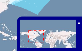
    OpenLayers.Control.OverviewMap
    generates a small overview map (see Section 2.3.4). This map shows the current view of the main map and serves as a positioning and navigational tool. The overview map is usually located in the lower right hand side of the map and can be minimized by pressing a button on the map edge. This class provides the functions needed for querying and setting of the selection rectangle, which can be moved by way of defined mouse events.

    OpenLayers.Control.KeyboardDefaults
    defines type and activities of (keyboard) key commands.

    OpenLayers.Control.MouseDefaults
    defines map activity during mouse events. This includes click, double-click, mouse wheel and mouse movement events.
Links
- Smart Map Browsing,Emanuel Schütze, Bremen University of Applied Sciences ,June 1st 2007: http://www.smartmapbrowsing.org
la API
Los Objectos de la biblioteca de Openlayers están bien descritos, en inglés, en la documentación el linea disponible en el sitio web:
Por cada clase hay una descripción detallada y se ofrece el listado de los atributos y funciones. Quien esta mas confiado con el código en general y el Javascript en especifico encontrará muy fácil desarrollar aplicaciones de mapas en la web que utilicen esta biblioteca.
Ejemplo en código
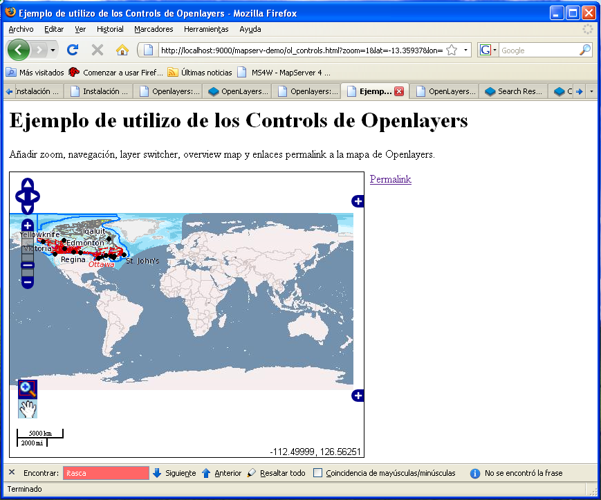
En el código que sigue tenemos un ejemplo sencillo de como se pueden integrar facilmente todos los Controls descriptos antes.
Lo podemos copiar y guardar en un fichero con recorrido:
C:\ms4w\apps\mapserv-demo\ol_controls.html
una vez guardado estará disponible en el servidor local con este enlace [4]:
el código
 <html xmlns="http://www.w3.org/1999/xhtml">
     <head>
         <title>Ejemplo de utilizo de los Controls de Openlayers</title>

 	<style type="text/css">
         #map {
             width: 512px;
             height: 412px;
             border: 1px solid black;
         }
         #permalink{
             position:absolute;
             margin-left:522px;
         }
     </style>
     <script src="http://www.openlayers.org/api/OpenLayers.js"></script>

 	<script type="text/javascript">
 		var map;
 		function init(){
 			map = new OpenLayers.Map('map', {
 				controls: [
 					new OpenLayers.Control.PanZoomBar(),
 					new OpenLayers.Control.MouseToolbar(),
 					new OpenLayers.Control.LayerSwitcher({'ascending':false}),
 					new OpenLayers.Control.ScaleLine(),
 					new OpenLayers.Control.Permalink('permalink'),
 					new OpenLayers.Control.MousePosition(),
 					new OpenLayers.Control.OverviewMap(),
 					new OpenLayers.Control.KeyboardDefaults()
 				],
 				numZoomLevels: 6

 			});


 			var ol_wms = new OpenLayers.Layer.WMS( "OpenLayers WMS",
 				"http://labs.metacarta.com/wms/vmap0",
 				{layers: 'basic'} );
 			var jpl_wms = new OpenLayers.Layer.WMS( "NASA Global Mosaic",
 				"http://t1.hypercube.telascience.org/cgi-bin/landsat7",
 				{layers: "landsat7"});
 			var dm_wms = new OpenLayers.Layer.WMS( "DM Solutions Demo",
 				"http://www2.dmsolutions.ca/cgi-bin/mswms_gmap",
 				{layers: "bathymetry,land_fn,park,drain_fn,drainage," +
 						 "prov_bound,fedlimit,rail,road,popplace",
 				 transparent: "true", format: "image/png" });

 			jpl_wms.setVisibility(false);
 			dm_wms.setVisibility(false);

 			map.addLayers([ol_wms, jpl_wms, dm_wms]);
 			if (!map.getCenter()) map.zoomToMaxExtent();
 		}
 	</script>

    </head>
    <body onload="init()">
        <h1>Ejemplo de utilizo de los Controls de Openlayers</h1>

        <p>
            Añadir zoom, navegación, layer switcher, overview map y enlaces
            permalink a la mapa de  Openlayers.
        </p>
         <a href="" id="permalink">Permalink</a>
         <div id="map"></div>
     </body>
 </html>
comentarios
el objecto mapa
En la creación del objecto mapa se añaden el parámetro de los Controls ("controls") y su valor es un array [5] que contiene todos los Controls que hemos visto antes.
                       map = new OpenLayers.Map('map', {
				controls: [
					new OpenLayers.Control.PanZoomBar(),
					new OpenLayers.Control.MouseToolbar(),
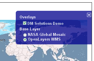
					new OpenLayers.Control.LayerSwitcher({'ascending':false}),
					new OpenLayers.Control.ScaleLine(),
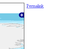
					new OpenLayers.Control.Permalink('permalink'),
					new OpenLayers.Control.MousePosition(),
					new OpenLayers.Control.OverviewMap(),
					new OpenLayers.Control.KeyboardDefaults()
				],
				numZoomLevels: 6

			});
En este caso solo los Controls LayerSwitcher y Permalink tienen atributos pero mirando la API nos podemos enterar de todas las funciones que cada uno de estos objectos tienen y que podemos utilizar para personalizar nuestra web.
Autores
Referencias
- ↑ Interfaz de programación de aplicaciones. Definición: http://es.wikipedia.org/wiki/API
- ↑ Interfaz gráfica de usuario. Definición: http://es.wikipedia.org/wiki/GUI
- ↑ Página oficial de ejemplo sobre los Controls. http://openlayers.org/dev/examples/controls.html
- ↑ Si habéis seguido las indicaciones de las lecciones publicadas en http://wiki.osgeo.org/wiki/Instalaci%C3%B3n_y_manejo_de_servicios_OWS_con_UMN_Mapserver_y_Openlayers
- ↑ Definición de Array. http://es.wikipedia.org/wiki/Array
Licencia
- la licencia por este articulo es: Creative Commons Attribution 3.0 License (http://creativecommons.org/licenses/by/3.0/deed.es).
- esta licencia permite:
- copiar, distribuir y comunicar públicamente la obra
- hacer obras derivadas
- bajo estas condiciones:
- Reconocimiento. Debe reconocer los créditos de la obra de la manera especificada por el autor o el licenciador (pero no de una manera que sugiera que tiene su apoyo o apoyan el uso que hace de su obra).
- Al reutilizar o distribuir la obra, tiene que dejar bien claro los términos de la licencia de esta obra.
- Alguna de estas condiciones puede no aplicarse si se obtiene el permiso del titular de los derechos de autor
- Nada en esta licencia menoscaba o restringe los derechos morales del autor.
Duración
Por esta clase se evalúa una duración de X oras
