Difference between revisions of "User:Mdavis"
Wiki-Mdavis (talk | contribs) |
|||
| (4 intermediate revisions by 2 users not shown) | |||
| Line 1: | Line 1: | ||
| + | {{OSGeo Member | ||
| + | |Name=Martin Davis | ||
| + | |JobTitle=Software Developer | ||
| + | |Company=OpenGeo | ||
| + | |Country=Canada | ||
| + | |City=Victoria | ||
| + | |Coordinate=48.4283327, -123.3649269 | ||
| + | |LocalChapter=British Columbia Chapter | ||
| + | |Email=mtnclimb AT gmail DOT com | ||
| + | |Website=http://lin-ear-th-inking.blogspot.ca/ | ||
| + | |Photo=martin_davis.jpg | ||
| + | |Info=Martin Davis has been an open source geospatial developer for over 10 years, primarily in Java. | ||
| + | He has a particular interest in geometric algorithms, and is the maintainer of the widely-used [http://sourceforge.net/projects/jts-topo-suite/ JTS Topology Suite] as well as assisting with the [http://geos.osgeo.org/ GEOS] port. | ||
| + | His other interest is in making spatial processing more accessible. | ||
| + | He is is the designer or lead developer for the | ||
| + | [http://www.openjump.org/ JUMP], JCS Conflation Suite, [http://trac.osgeo.org/proj4j/ Proj4J] and [http://tsusiatsoftware.net/jeql/main.html JEQL] software projects. | ||
| + | }} | ||
| + | {{OSGeo Experience | ||
| + | |User=Yes | ||
| + | |Committee=No | ||
| + | |Board=No | ||
| + | |Coder=Yes | ||
| + | |Translate=No | ||
| + | |PSC=No | ||
| + | |ExBoard=No | ||
| + | |Charter=No | ||
| + | |Chair=No | ||
| + | |SolKatz=Yes | ||
| + | |Committer=No | ||
| + | }} | ||
===[[User:Mdavis|Martin Davis]]=== | ===[[User:Mdavis|Martin Davis]]=== | ||
| Line 7: | Line 37: | ||
Location: Victoria, Canada | Location: Victoria, Canada | ||
| − | Martin Davis has been | + | Martin Davis has been an open source geospatial developer for over 10 years, primarily in Java. |
| − | He is the | + | He has a particular interest in geometric algorithms, and is the maintainer of the widely-used [http://sourceforge.net/projects/jts-topo-suite/ JTS Topology Suite] as well as assisting with the [http://geos.osgeo.org/ GEOS] port. |
| − | [http://geos.osgeo.org/ GEOS] | + | His other interest is in making spatial processing more accessible. |
| + | He is is the designer or lead developer for the | ||
[http://www.openjump.org/ JUMP], JCS Conflation Suite, [http://trac.osgeo.org/proj4j/ Proj4J] and [http://tsusiatsoftware.net/jeql/main.html JEQL] software projects. | [http://www.openjump.org/ JUMP], JCS Conflation Suite, [http://trac.osgeo.org/proj4j/ Proj4J] and [http://tsusiatsoftware.net/jeql/main.html JEQL] software projects. | ||
| Line 29: | Line 60: | ||
;Profile last updated: 21 Sept 2012 | ;Profile last updated: 21 Sept 2012 | ||
| + | |||
| + | [[Category:Sol Katz Awardee]] | ||
| + | [[Category:OSGeo Charter Member]] | ||
| + | |||
| + | [[Category:OSGeo Advocate]] | ||
Latest revision as of 11:15, 2 December 2015
| OSGeo Member | ||
|---|---|---|
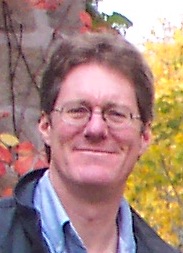
| Name: | Martin Davis |  |
| Job Title: | Software Developer | |
| Company: | OpenGeo | |
| Address: | ||
| City: | Victoria | |
| State: | ||
| Country: | Canada | |
| Local Chapter: | British Columbia Chapter | |
| Email: | mtnclimb AT gmail DOT com | |
| Phone: | ||
| Instant Messaging: | ||
| Website: | http://lin-ear-th-inking.blogspot.ca/ | |
| Language(s): | ||
| Personal Description : | Martin Davis has been an open source geospatial developer for over 10 years, primarily in Java.
He has a particular interest in geometric algorithms, and is the maintainer of the widely-used JTS Topology Suite as well as assisting with the GEOS port. His other interest is in making spatial processing more accessible. He is is the designer or lead developer for the JUMP, JCS Conflation Suite, Proj4J and JEQL software projects. |
|
|
|
||
URIs of the form "mtnclimb AT gmail DOT com" are not allowed. [[Info::Martin Davis has been an open source geospatial developer for over 10 years, primarily in Java.
He has a particular interest in geometric algorithms, and is the maintainer of the widely-used JTS Topology Suite as well as assisting with the GEOS port. His other interest is in making spatial processing more accessible. He is is the designer or lead developer for the JUMP, JCS Conflation Suite, Proj4J and JEQL software projects.| ]]
OSGeo Experience and Roles:
Martin Davis
Software Developer, OpenGeo
Location: Victoria, Canada
Martin Davis has been an open source geospatial developer for over 10 years, primarily in Java. He has a particular interest in geometric algorithms, and is the maintainer of the widely-used JTS Topology Suite as well as assisting with the GEOS port. His other interest is in making spatial processing more accessible. He is is the designer or lead developer for the JUMP, JCS Conflation Suite, Proj4J and JEQL software projects.
- Blog: lin.ear th.inking
- Website: Tsusiat Software
- Contributor to GeoTools
- Contributor to GeoServer
- Contributor to GEOS
- PSC member of MetaCRS
- Lead Developer for Proj4J
- 2011 Winner of the Sol Katz Award
- Contact
- Email: mtnclimb AT gmail DOT com
- Skype: mdavis111
- Profile last updated
- 21 Sept 2012