Difference between revisions of "GvSIG Report 2008"
Jump to navigation
Jump to search
m (→Key Accomplishments: added mor info about gvsig portal) |
|||
| Line 5: | Line 5: | ||
=== Key Accomplishments === | === Key Accomplishments === | ||
| − | * The community portal (http://www.gvsig.org) | + | * The community portal (http://www.gvsig.org) allowed to publish: |
| + | ** User documentation (in several languages) | ||
| + | ** Tehcnical documentation (at this moment only in English) | ||
| + | ** A catalog of contributions (new extensions, non-official gvSIG releases, more documentation, etc.) | ||
* gvSIG mailing lists have grown in subscribers (more than 2300, see numbers below) and a new mailing list has been created for the the Italian community | * gvSIG mailing lists have grown in subscribers (more than 2300, see numbers below) and a new mailing list has been created for the the Italian community | ||
* The project source repository has been published at http://subversion.gvsig.org | * The project source repository has been published at http://subversion.gvsig.org | ||
| + | * A new public FTP repository has been published at ftp://gvsig.org | ||
| + | * Releases of gvSIG extensions and releases during 2008: | ||
| + | ** First 3D pilot extension ( [http://tinyurl.com/bkr27v 7 of January]) | ||
| + | ** ArcSDE extension ([http://tinyurl.com/bdj5lt 6 of February]) | ||
| + | ** gvSIG 1.1.2 ([http://tinyurl.com/cwomzm 4 of March]) | ||
| + | ** First official release of gvSIG Mobile ([http://tinyurl.com/d4k5db 13 of March]) | ||
| + | ** Raster pilot extension ([http://tinyurl.com/b4vmjb 27 of March]) | ||
| + | ** Publishing extension ([http://tinyurl.com/bpde5u 30 of July]) | ||
| + | ** Metadata management extension ([http://tinyurl.com/bsl3nc 23 of September]) | ||
| + | ** gvSIG 1.9alpha ([http://tinyurl.com/cclq4n 27 of November]) | ||
* International events where gvSIG project has been officially represented: | * International events where gvSIG project has been officially represented: | ||
** ''Primer simposio GIS Educación en América Latina'', Quito, Ecuador | ** ''Primer simposio GIS Educación en América Latina'', Quito, Ecuador | ||
| Line 18: | Line 31: | ||
** ''Open Source World Conference'', Málaga, Spain | ** ''Open Source World Conference'', Málaga, Spain | ||
** ''II Jornadas SIG Libre'', Girona, Spain | ** ''II Jornadas SIG Libre'', Girona, Spain | ||
| − | |||
| − | |||
| − | |||
| − | |||
| − | |||
| − | |||
| − | |||
| − | |||
| − | |||
====Downloads==== | ====Downloads==== | ||
Revision as of 04:48, 3 March 2009
Please use 2nd level heading for your project name
gvSIG
- Contact name: Jorge Sanz
Key Accomplishments
- The community portal (http://www.gvsig.org) allowed to publish:
- User documentation (in several languages)
- Tehcnical documentation (at this moment only in English)
- A catalog of contributions (new extensions, non-official gvSIG releases, more documentation, etc.)
- gvSIG mailing lists have grown in subscribers (more than 2300, see numbers below) and a new mailing list has been created for the the Italian community
- The project source repository has been published at http://subversion.gvsig.org
- A new public FTP repository has been published at ftp://gvsig.org
- Releases of gvSIG extensions and releases during 2008:
- First 3D pilot extension ( 7 of January)
- ArcSDE extension (6 of February)
- gvSIG 1.1.2 (4 of March)
- First official release of gvSIG Mobile (13 of March)
- Raster pilot extension (27 of March)
- Publishing extension (30 of July)
- Metadata management extension (23 of September)
- gvSIG 1.9alpha (27 of November)
- International events where gvSIG project has been officially represented:
- Primer simposio GIS Educación en América Latina, Quito, Ecuador
- Intergeo, Bremen, Germany
- FOSSGIS2008, Freiburg, Germany
- FOSS4G2008, Cape Town, South Africa
- Latinoware'08, Foz de Iguazú, Brasil
- 1er encuentro Geomática Libre, Mérida, Venezuela
- AGIT, Salzburg, Germany
- Open Source World Conference, Málaga, Spain
- II Jornadas SIG Libre, Girona, Spain
Downloads
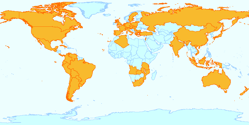
These are approximate numbers about gvSIG releases downloads during 2008 (as of 17 of December of 2008):
|
|
| |||||||||||||||||||||||||||||||||||||||||||||||||||||||||||||||
Other statistics
- gvSIG GUI translated in more than 20 languages
- Mailing lists subscribers:
- Users: 1255
- Developers: 618
- International: 521
- Italian: 160
- Known countries with registered users: 42
- Known countries where gvSIG has been downloaded: 59
Areas for Improvement
gvSIG project needs to:
- Open the bug tracking system
- Open the gvSIG project organization to the community
- Stablish a fixed release schedule (like Ubuntu Linux)
- Create more technical documentation in English
Opportunities to Help
- Test gvSIG and report bugs and annoyances at mailing lists
- Write use cases and report them
- Offer services (development, training) with gvSIG
- Propose new features and discuss them on the mailing lists
Outlook for 2009
- Start a new organization to strength the project and allow new companies, universities and public administrations to participate actively on the project management
- Start a community-driven formal testing
- Release a stable version of gvSIG with new features:
- Refactored data access (hopefully without users taking account of it)
- New symbology support
- Raster analysis (classification, principal components analysis, mosaic, etc.)
- Network geoprocessing
- Topology creation, editing and validating
- 3D support
- And others: LIDAR, geocoding, reports and charts, WPS,...
- Release a stable version of gvSIG Mobile with new features:
- Refactored core with gvSIG desktop compatibility
- Full editing
- Custom forms
- Phone ME support (finally a trully free JVM for PDA!)
- GPS library
- OpenMoko and Android versions
