Intergeo 2006
Intergeo 2006 10-12 October 2006 (Munich, Germany). The OSGeo operates a booth area providing resources for Open Source GIS software projects and space for commercial enterprises. The LinuxTag 2006 event featured a small forerunner of the OSGeo booth.
Booth
The Open Source Park is operated by the OSGeo, preliminary plans are available on the Operate OSGeo Booth Wiki page. There will be two exhibit categories 'Booth' and 'InfoPoint'. Free Software Geo, GIS and community projects can request for an InfoPoint free of cost.
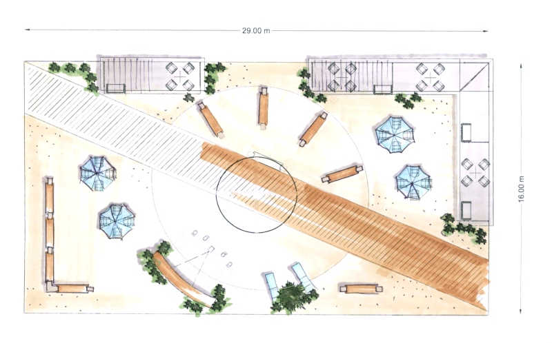
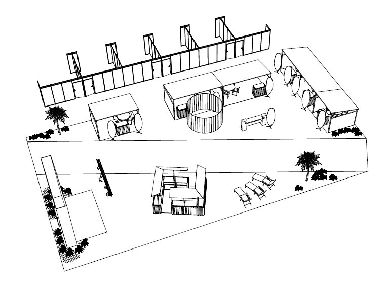
The following two sketches show the booth floor plan (kindly provided by Hinte Messe GmbH).
Sponsors
Booth area in the Open Source Park of the Intergeo can be acquired by businesses that are active in fostering OS GIS software and furthering the development of the OSGeo Foundation. Read more about the proposed OSGeo Promotion Application.
Please add yourself to the following list if you are interested. This is not an official confirmation but just an expression of interest. Details regarding the cost, infrastructure and additional services provided by the OSGeo Open Source Park are available for download at VisCom. Do not use this document to apply for a booth directly as your application has to be evaluated by OSGeo first. Please subscribe to VisCom mailing list for general information and [1] for application. Find all sent messages in the Archive.
Kriterien zur Auswahl der Sponsoren
Die Geschäftsmodelle rund um Freie und Open Source Software unterscheiden sich in vielen Punkten grundsätzlich von propritären Geschäftsmodellen. Auf dem Open Source Park stellen ausschließlich Unternehmen und Organisationen aus, die den Kriterien zur Auswahl von Sponsoren der Open Source Geopspatial Foundation genüge leisten. Durch die Vielfalt unterschiedlicher Geschäftmodelle und Arbeitsbereiche kann nicht jedes Unternehmen alle Kriterien erfüllen, deshalb kann in einigen Fällen eine individuelle Betrachtung erforderlich sein. Schreiben Sie sich in die Mailing Liste ein, um Ihr Unternehmensprofil vorzustellen, falls Sie sich nicht sicher sind, ob sie genügend Kriterien erfüllen. Die folgende Liste gibt einen ersten Anhaltspunkt, alle Punkte sind immer in Bezug auf die Geoinformationsverarbeitung zu sehen.
- Unternehmen, in deren Geschäftsmodell Freie Software ein zentrales Element darstellt
- Aktives Engagement in der Open Source Geospatial Foundation (z.B. OSGeo Foundation Sponsorship)
- Aktive Förderung der Produktion von Freier und Open Source Software (Entwicklung)
- Aktive Förderung der Nutzung von Freier und Open Source Software (nicht nur Schulung, sondern z.B. auch Veröffentlichung der Unterlagen)
- Übersetzung von FOSSGIS Software Dokumentationen, Online Hilfen, etc.
- Förderung der Nutzung und Verbreitung von FOSSGIS in der Lehre
- (bitte weitere Punkte anfügen)
Eine schwer einzuschätzende Leistung ist z.B. Unterstützung in Email-Liste, da sie auf persönlicher Basis gewährt wird, oft aber auch während der Arbeitszeit in einem Unternehmen erfolgt.
Free and Open Source Community Exhibitors
These Free and Open Source communities will appear at the Open Source Park and highlight their projects. If you are interested in appearing at the Intergeo 2006 please mailto:arnulf@osgeo.org
- OSGeo Foundation
- GDAL/OGR
- Community MapBuilder
- deegree
- GRASS Anwender-Vereinigung e.V. (GAV)
- Mapbender
- MapServer
- PostGIS
Professional Service Provider Exhibitors
The following service provider will appear at the Open Source Park of the Intergeo 2006. If you are interested in appearing at the Intergeo 2006 please mailto:arnulf@osgeo.org
- 52°North (Booth)
- Autodesk (Booth)
- Geo-Consortium (Booth)
- Intevation GmbH (Booth)
- lat/lon & Delphi IMM & IDgis bv (Booth)
- MapMedia & IVU (Booth)
- SAG-EL (Info Point)
Agenda Open Source Park
All interested Free and Open Source Community Members and Professional Service Provider Exhibitors are invited to give a presentation in the Open Source Park. Please register your wishes for date, time and title of your presentation and your e-mail adress to contact you. The presentation should NOT be longer than 15 minutes. The schedule will be worked out in this Wiki. If there are not enough time slots we will have to sort this out through the mailing list.
| DATE | TIME | TITLE | SPEAKER | |
| daily | once or more a day | PostGIS: Geospatial Database | Frank Koormann | Frank.Koormann@intevation.de |
| daily | twice a day, 15 Min, | Eine Einführung in die OSGeo | Arnulf Christl | arnulf@osgeo.org |
| daily | twice a day | Neuigkeiten in der Software Mapbender | Uli Rothstein et al | uli@osgeo.org |
| daily | twice a day / on request | http://www.gis-macht-schule.de, ein freies Angebot für die Schule/Ausbildung (GIS for schools/education) | Georg Lösel / GAV | grass@de-schorsch.de |
| one day | once or twice | Das Geoportal der Metropolregion Hamburg (http://mapservices.geonord.de/mrh-portal) | Katharina Lupp | Katharina.Lupp@gv.hamburg.de |
| daily | twice a day | OpenCatalogue - Die Open Source Metadaten-Lösung | Rolf Lessing, Markus Müller | rolf.lessing@delphi-imm.de, mueller@lat-lon.de |
| daily | twice a day | deegree iGeoSecurity - Sichere OGC Web Services | Hans Plum, Jens Fitzke, Markus Müller | [fitzke|mueller|plum]@lat-lon.de |
| daily | twice a day | Zugang zu Geodateninfrastrukturen mit deegree iGeoPortal | Hans Plum, Jens Fitzke, Markus Müller | [fitzke|mueller|plum]@lat-lon.de |
| daily | once or twice a day | Geometry editing and animation of time dimension using Flash and deegree | Herman Assink | herman.assink@idgis.nl |
| daily | once or twice a day | Einfache WebGIS-Administration mit MapStorer | Olaf Knopp | oknopp@kartago.de |
| daily | once or twice a day | Accessing protected OGC Services: The 52N Security System | Jan Drewnak/Rüdiger Gartmann | drewnak@52north.org, gartmann@52north.org |
| daily | once or twice a day | "plug & play" with SWE: Sensor Web Enablement in 52°North | Ingo Simonis/Andreas Wytzisk | simonis@52north.org, wytzisk@52north.org |
| Wednesday | once | Das Open Source-basierte Geoportal der GIB | Michael Dreesmann | michael.dreesmann@geobasis-bb.de |
| Tuesday | once | Erfolgreicher Einsatz von Open Source Technologie in
aktuellen GDI-Projekten |
Simone Maas | maa@ivu.de |
| Tuesday | once | Dynamische Objekt-Visualisierung in Echtzeit für
Verkehrsleitstellen |
Jörn Baetge | bae@ivu.de |
| daily | once | Festpunkt-Informationssystem-Online, eine WebGIS-Fachschale | Jörg Thomsen | jt@mapmedia.de |

