Difference between revisions of "Sri Lanka"
| (53 intermediate revisions by 5 users not shown) | |||
| Line 1: | Line 1: | ||
| − | <!--Find more information on the '''[http://osgeo. | + | <!--Find more information on the '''[http://osgeo.lk Sri Lanka Chapter of OSGeo]''' web site. --> |
== '''About OSGeo-Sri Lanka (LK) Chapter''' == | == '''About OSGeo-Sri Lanka (LK) Chapter''' == | ||
| + | [[File:OsgeoSLChapter logo green brown.png|thumbnail|OSGeo Sri Lanka Local chapter logo]] | ||
| − | + | Welcome to the OSGeo Sri Lanka chapter! | |
| + | |||
| + | The OSGeo Sri Lanka chapter is aimed at supporting the Sri Lankan open source GIS community in their activities. The chapter is formally recognised in August 2018 though the OSGeo and open source GIS activities are being conducted around the country for nearly a decade before that . FOSSGIS and open data have become an attractive tools and resources in disaster management, town and country planning, water resource management and community activities and therefore have become part of teaching and learning in universities and organisations as well. | ||
| − | + | The First formal meeting of the chapter was held on 19th October 2017 at the Department of Town & Country Planning (TCP), University of Moratuwa . | |
| − | |||
| − | |||
| − | |||
| − | === | + | === Mission === |
| − | + | * Advocate the use of Free and open source GIS tools and open data among local community | |
| − | * | + | * Promote localized GIS solutions which cater for Sri Lankan people’s requirements |
| − | * | + | * Support the OSGeo activities at international and regional levels (such as Asian regional activities) |
| − | * | + | * Act as a bridge between various groups like developers, application users, students, educational Institutes, government departments and community groups who can be benefited from open source GIS |
| + | * Foster an open environment to grow , collaborate and networking as a community while sharing OSGeo value system | ||
| − | + | === Objectives === | |
| − | |||
| − | |||
| − | |||
| − | + | * Conduct events related to GIS and open source GIS to increase awareness and networking | |
| − | * | + | * Provide technical guidance and support to implement open source GIS local solutions and entrepreneurship based on FOSS GIS |
| − | * | + | * Develop open source GIS training material suitable for local communities , using local datasets and examples |
| − | * | + | * Conduct training and support R & D activities related to open source GIS , collaborative with universities and other organizations |
| − | * | + | * Offer mentoring support for open source GIS projects at university and other levels of education |
| − | * | + | * Maintain a repository of local open source GIS activities including events, development of software tools and training materials |
| − | * | ||
| − | |||
| − | |||
| − | |||
| − | |||
=== Legal status === | === Legal status === | ||
| + | There is no requirement from OSGeo to a local chapter have a legal existence. However, as it would be much convenience in the long run, we are in the process of registering the Sri Lankan chapter as a community organization in Sri Lanka. | ||
| + | |||
| + | == '''OSGeo.LK Chapter Officers'''== | ||
| + | <b>Interim committee </b><br> | ||
| + | <b>President</b><br> | ||
| + | * [https://wiki.osgeo.org/wiki/User:Nimalika Nimalika Fernando] | ||
| + | <b>Vice President</b><br> | ||
| + | *[[Rangajeewa Ratnayake]] | ||
| + | <b>Secretary</b><br> | ||
| + | *[[Malika Gunawardana]] | ||
| + | <b>Vice Secretary</b><br> | ||
| + | *[[Maheshika Karunarathne]] | ||
| + | <b>Treasurer</b><br> | ||
| + | *[[Amila Jayasinghe]] | ||
| + | <b>Vice Treasurer</b><br> | ||
| + | *[[Pradeep Kalansooriya]] | ||
| − | |||
| − | <b> | + | <b>Executive Members</b><br> |
| + | *[[Ajith Karunarathne]] | ||
| + | *[[Niroshan Sanjaya]] | ||
| + | *[[Aruna Bandara]] | ||
| + | *[https://wiki.osgeo.org/wiki/User:Suthakaran Suthakaran Sundaralingam] | ||
| + | *[[Thambirajah Sunthararajah]] | ||
| + | *[[Malinga Prabhasara]] | ||
| + | ..Add Executive Members here | ||
| − | <b> | + | <b>Advisors</b><br> |
| + | * [[Venkatesh Raghavan]] | ||
| + | * [[Jeff McKenna]] | ||
| + | * [[Yann Chemin]] | ||
| + | * [[Massimiliano Cannata]] | ||
| + | * [[Sundaramoorthy Sivanantharajah]] | ||
| − | + | ..Add Advisers here | |
| + | <b>Past officials</b> | ||
| + | *[[H.H.K.R.Nayomi]] ( first Secretory ) | ||
| + | *[[Sirimewan Waidyasekara]] ( Member of the Advisory board, initial member) | ||
| − | + | == '''Initial Membership''' == | |
| + | * [https://wiki.osgeo.org/wiki/Yann_Chemin Chamin Yann Chemin ] | ||
| + | * [https://wiki.osgeo.org/wiki/User:Nimalika Nimalika Fernando] | ||
| + | * [https://www.linkedin.com/in/malika-gunawardana-0677a078/ Malika Gunawardana] | ||
| + | * [https://www.linkedin.com/in/amila-jayasinghe-1bbb753a Amila Jayasinghe] | ||
| + | * Sirimewan Waidyasekera | ||
| + | * Sunthararajah Thambirajah | ||
| + | * Sundaramoorthy Sivanantharajah | ||
| + | ..Add members here | ||
| + | == '''Members''' == | ||
| + | '''Participating Members''' | ||
| + | *[https://www.linkedin.com/in/prabhath-w-j-k-a-n-a49b05119/?originalSubdomain=lk Nishan Prabath] | ||
| + | '''Supporting Members''' | ||
| + | * | ||
| + | '''Full Members''' | ||
| + | * | ||
| − | + | == '''Activities of OSGeo.LK Chapter ''' == | |
| + | '''2018''' | ||
| + | * [http://www.foss4g-asia.org/2018/ FOSS4G-Asia 2018] was held in the University of Moratuwa, Sri Lanka. | ||
| − | .. | + | * A series of mapping workshops were conducted from May 2018 with the support of HOT micro grant (3990US$) for mapping Sri Lanka with OSM. Volunteering their time and effort, our OSM experts lead by Suthakaran are working tirelessly travelling around the country to make these events fully successful and useful for the community. |
| − | + | '''2017''' | |
| − | + | * First meeting to formalise the chapter activities (19th October 2017) . [[File:SriLankaChapter MINUTES01 16 11 2017 approved.pdf|thumb|Meeting minutes-1]] | |
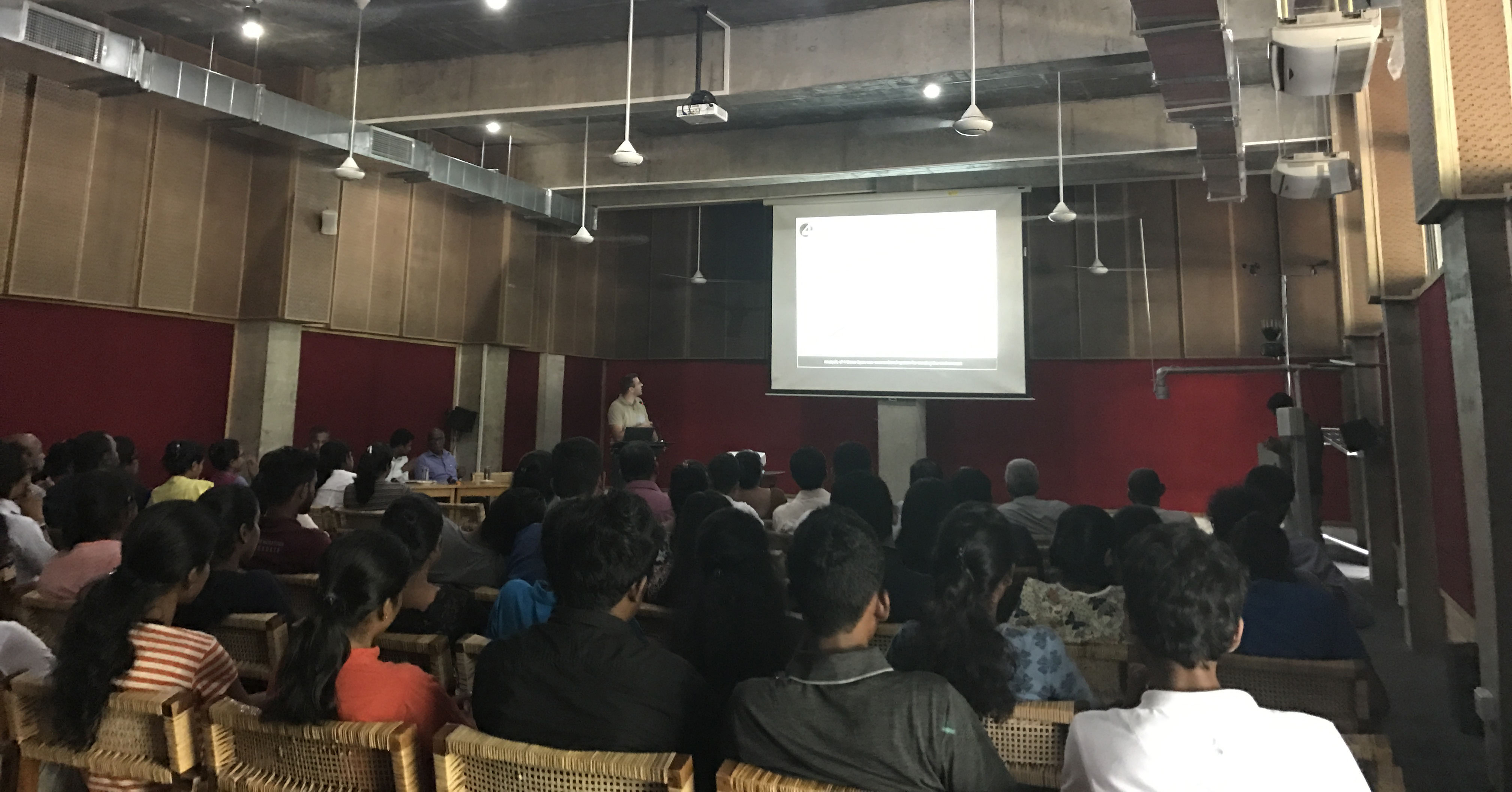
| − | * | + | * Second meeting of the year 2017 (15th November 2017) & Workshop on Open, Nonconventional, Sustainable and Effective climate monitoring system (4ONSE) |
| − | + | [[File:SriLankaChapter_MINUTES02_05_12_2017_approved.pdf|Meeting minutes-2]] | |
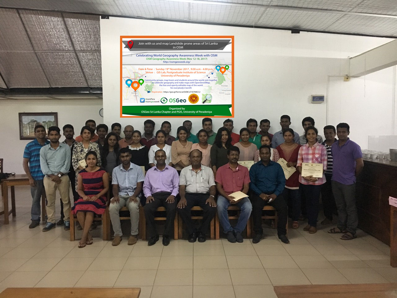
| − | = | + | * Event to Celebrate GeoWeek 2017 (OSM Mapathon at University of Peradeniya - 19th November 2017).<ref name="OSM Mapathon pdf">[https://wiki.osgeo.org/images/1/1e/OSM_workshop_UoPeradeniya_summary.pdf OSM Mapathon at University of Peradeniya - 19th November 2017].</ref> |
| + | |||
| + | [[File:4ONSEworkshop_Moratuwa.jpg|thumb|right|333px|4ONSE workshop at UoMoratuwa on 15-11-2017]] | ||
| + | [[File:OSMgeoweek UoPeradeniya.jpg|thumb|right|333px|OSM GeoWeek Celebration at UoPeradeniya on 19-11-2017]] | ||
'''2014''' | '''2014''' | ||
* Formation of OSGeo lab of University of Moratuwa and [http://osgeolab.sliit.lk/ OSGeo Lab of SLIIT] | * Formation of OSGeo lab of University of Moratuwa and [http://osgeolab.sliit.lk/ OSGeo Lab of SLIIT] | ||
| − | * | + | * organising FOSS4G Sri Lanka -2014 |
| + | |||
* Add Activity | * Add Activity | ||
| + | == Join our community == | ||
| + | * OSGeo Sri Lanka chapter welcome open source GIS enthusiasts actively engage in any form of GIS related activities. | ||
| + | * Membership is Open to anyone who follows the OSGeo foundation's mission & goals, and support the mission & the objectives of the OSGeo Sri Lanka Chapter. We offer several categories of membership categories for the benefit of people from diverse backgrounds. | ||
| + | |||
| + | '''How to become a member''' | ||
| + | * To join with us, please drop an email to osgeo.sri.lanka@gmail.com - [mailto:osgeo.sri.lanka@gmail.com] with your name, email & other contact details, membership type you think most suits and a personal statement indicating your interest and involvement in open source GIS activities. We will come back to you soon. | ||
| + | * Then you can puts your name in the membership section of OSGeo-Sri Lanka wiki page and registers on the community mailing list if not done so far. | ||
| + | |||
| + | * Membership types as per by-laws ( Extracted from the by-laws )[[File:MembershipDescriptionSriLankaChapter.pdf|thumbnail|Membership types as per by-laws]] | ||
== Communication == | == Communication == | ||
* Through mailing lists | * Through mailing lists | ||
| − | ** Discuss: subscribe at http://lists.osgeo.org/cgi-bin/mailman/listinfo/ | + | ** Discuss: subscribe at http://lists.osgeo.org/cgi-bin/mailman/listinfo/srilanka |
| − | ** Board: subscribe at http://lists.osgeo.org/cgi-bin/mailman/listinfo/lk-board | + | ** Board: subscribe at http://lists.osgeo.org/cgi-bin/mailman/listinfo/lk-board |
| + | ** Please feel free to contact the chapter via osgeo.sri.lanka@gmail.com -[mailto:osgeo.sri.lanka@gmail.com] | ||
| + | ** Please initiate or join discussions on local mailing list listed above. | ||
== '''Links''' == | == '''Links''' == | ||
Latest revision as of 07:30, 22 January 2020
About OSGeo-Sri Lanka (LK) Chapter
Welcome to the OSGeo Sri Lanka chapter!
The OSGeo Sri Lanka chapter is aimed at supporting the Sri Lankan open source GIS community in their activities. The chapter is formally recognised in August 2018 though the OSGeo and open source GIS activities are being conducted around the country for nearly a decade before that . FOSSGIS and open data have become an attractive tools and resources in disaster management, town and country planning, water resource management and community activities and therefore have become part of teaching and learning in universities and organisations as well.
The First formal meeting of the chapter was held on 19th October 2017 at the Department of Town & Country Planning (TCP), University of Moratuwa .
Mission
- Advocate the use of Free and open source GIS tools and open data among local community
- Promote localized GIS solutions which cater for Sri Lankan people’s requirements
- Support the OSGeo activities at international and regional levels (such as Asian regional activities)
- Act as a bridge between various groups like developers, application users, students, educational Institutes, government departments and community groups who can be benefited from open source GIS
- Foster an open environment to grow , collaborate and networking as a community while sharing OSGeo value system
Objectives
- Conduct events related to GIS and open source GIS to increase awareness and networking
- Provide technical guidance and support to implement open source GIS local solutions and entrepreneurship based on FOSS GIS
- Develop open source GIS training material suitable for local communities , using local datasets and examples
- Conduct training and support R & D activities related to open source GIS , collaborative with universities and other organizations
- Offer mentoring support for open source GIS projects at university and other levels of education
- Maintain a repository of local open source GIS activities including events, development of software tools and training materials
Legal status
There is no requirement from OSGeo to a local chapter have a legal existence. However, as it would be much convenience in the long run, we are in the process of registering the Sri Lankan chapter as a community organization in Sri Lanka.
OSGeo.LK Chapter Officers
Interim committee
President
Vice President
Secretary
Vice Secretary
Treasurer
Vice Treasurer
Executive Members
- Ajith Karunarathne
- Niroshan Sanjaya
- Aruna Bandara
- Suthakaran Sundaralingam
- Thambirajah Sunthararajah
- Malinga Prabhasara
..Add Executive Members here
Advisors
..Add Advisers here
Past officials
- H.H.K.R.Nayomi ( first Secretory )
- Sirimewan Waidyasekara ( Member of the Advisory board, initial member)
Initial Membership
- Chamin Yann Chemin
- Nimalika Fernando
- Malika Gunawardana
- Amila Jayasinghe
- Sirimewan Waidyasekera
- Sunthararajah Thambirajah
- Sundaramoorthy Sivanantharajah
..Add members here
Members
Participating Members
Supporting Members
Full Members
Activities of OSGeo.LK Chapter
2018
- FOSS4G-Asia 2018 was held in the University of Moratuwa, Sri Lanka.
- A series of mapping workshops were conducted from May 2018 with the support of HOT micro grant (3990US$) for mapping Sri Lanka with OSM. Volunteering their time and effort, our OSM experts lead by Suthakaran are working tirelessly travelling around the country to make these events fully successful and useful for the community.
2017
- First meeting to formalise the chapter activities (19th October 2017) . File:SriLankaChapter MINUTES01 16 11 2017 approved.pdf
- Second meeting of the year 2017 (15th November 2017) & Workshop on Open, Nonconventional, Sustainable and Effective climate monitoring system (4ONSE)
File:SriLankaChapter MINUTES02 05 12 2017 approved.pdf
- Event to Celebrate GeoWeek 2017 (OSM Mapathon at University of Peradeniya - 19th November 2017).[1]
2014
- Formation of OSGeo lab of University of Moratuwa and OSGeo Lab of SLIIT
- organising FOSS4G Sri Lanka -2014
- Add Activity
Join our community
- OSGeo Sri Lanka chapter welcome open source GIS enthusiasts actively engage in any form of GIS related activities.
- Membership is Open to anyone who follows the OSGeo foundation's mission & goals, and support the mission & the objectives of the OSGeo Sri Lanka Chapter. We offer several categories of membership categories for the benefit of people from diverse backgrounds.
How to become a member
- To join with us, please drop an email to osgeo.sri.lanka@gmail.com - [1] with your name, email & other contact details, membership type you think most suits and a personal statement indicating your interest and involvement in open source GIS activities. We will come back to you soon.
- Then you can puts your name in the membership section of OSGeo-Sri Lanka wiki page and registers on the community mailing list if not done so far.
- Membership types as per by-laws ( Extracted from the by-laws )File:MembershipDescriptionSriLankaChapter.pdf
Communication
- Through mailing lists
- Discuss: subscribe at http://lists.osgeo.org/cgi-bin/mailman/listinfo/srilanka
- Board: subscribe at http://lists.osgeo.org/cgi-bin/mailman/listinfo/lk-board
- Please feel free to contact the chapter via osgeo.sri.lanka@gmail.com -[2]
- Please initiate or join discussions on local mailing list listed above.


