Difference between revisions of "Indonesia"
| (33 intermediate revisions by 22 users not shown) | |||
| Line 4: | Line 4: | ||
== Interested Members == | == Interested Members == | ||
| + | * [[User:Arnulf Christl | Arnulf Christl]] | ||
* [[User:Christoph | Christoph Baudson]] | * [[User:Christoph | Christoph Baudson]] | ||
| − | |||
* [[User:Yusi | Yusi Tyroni Mursityo ]] | * [[User:Yusi | Yusi Tyroni Mursityo ]] | ||
* [[User:Aw3126 | Agus Wibowo ]] | * [[User:Aw3126 | Agus Wibowo ]] | ||
| + | * [[User:rennodwi | Renno Dwi Prasetyo ]] | ||
* [[User:fthamura | Frans Thamura ]] | * [[User:fthamura | Frans Thamura ]] | ||
| − | * | + | * [[User:Rachmawan | Rachmawan Adi L. ]] |
| + | * [[User:sapto | Sapto Nugroho ]] | ||
| + | * [[User:Hendra Aquan | Hendra Aquan]] | ||
| + | * [[User:widyantoa | Adi Widyanto ]] | ||
| + | * [[User:Firman Hadi | Firman Hadi]] | ||
| + | * [[User:Irina | Irina Mildawani]] | ||
| + | * [[User:Tutut | Tutut Usaheni]] | ||
| + | * [[User:Amrullah | Amrullah]] | ||
| + | * [[User:Jafar |Jafar Elly]] | ||
| + | * [[User:Inggit |Inggit Sari]] | ||
| + | * [[User:Yuki Istianto | Yuki Istianto ]] | ||
| + | * [[User:Hariyanto | Hariyanto ]] | ||
| + | * [[User:Yadi | Yadi ]] | ||
| + | * [[User:Perdanarobert | PerdanaRobert ]] | ||
| + | * [[User:c4hy4 | Nuryani Y.S. ]] | ||
| + | * [[User:Nurhayati Masthurah | Nurhayati Masthurah ]] | ||
| + | * [[User:sukris | Sukristiyanti ]] | ||
| + | * [[User:dianoktiari | Dian Oktiari ]] | ||
| + | * [[User:mfaridazis | Farid Azis ]] | ||
| + | * [[User:Bsetyadji | Bambang Setyadji ]] | ||
== Projects in Region == | == Projects in Region == | ||
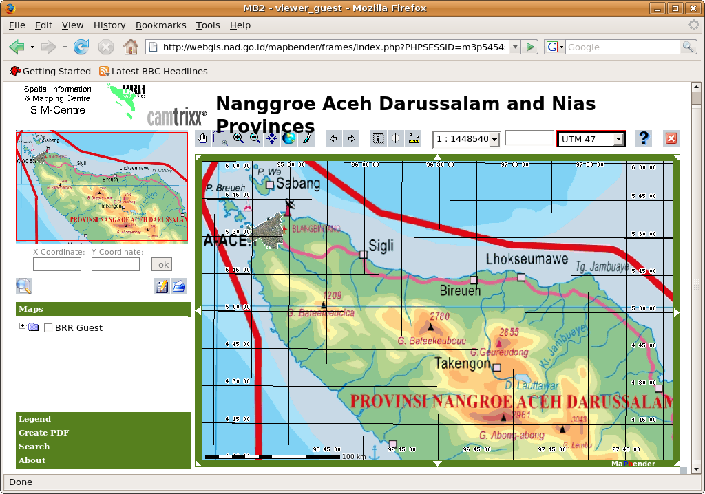
| − | Link to BAKOSURTANAL - Badan Koordinasi Survei dan Pemetaan Nasional (National Coordinating Agency for Surveys and Mapping). The project displays aerial photography related to the Tsunami catastrophy using MapServer and Mapbender. The frame is a prototype only, but the data is there. Login as guest/guest at http://www. | + | [[Image:Nanggroe aceh darussalam and nias.png|thumb|350pix|right|Screenshot of FOSSGIS application in Indonesia]] |
| + | |||
| + | Link to BAKOSURTANAL - Badan Koordinasi Survei dan Pemetaan Nasional (National Coordinating Agency for Surveys and Mapping). The project displays aerial photography related to the Tsunami catastrophy using MapServer and Mapbender. The frame is a prototype only, but the data is there. Login as guest/guest at http://www.webgis.nad.go.id/mapbender/frames/login.php or load the [http://webgis.nad.go.id/cgi-bin/mapserv?map=/www/data/mapfile/brr_guest.map&VERSION=1.1.1&REQUEST=GetCapabilities&SERVICE=WMS WMS Capabilties]. | ||
| + | |||
| + | == Training == | ||
| + | [[ToT FOSSGIS 07]] - Training of Trainers conducted in PDII-LIPI Jakarta, Indonesia, 22-26 October 2007. | ||
== Conferences == | == Conferences == | ||
Latest revision as of 07:02, 6 November 2011
There is an Indonesian language mailing list at the OSGeo. Feel free to subscribe.
Additionally it would be helpful to add people to a list of members who actively contribute to this emerging Local Chapters. Feel free to add anything that is of matter to this page.
Interested Members
- Arnulf Christl
- Christoph Baudson
- Yusi Tyroni Mursityo
- Agus Wibowo
- Renno Dwi Prasetyo
- Frans Thamura
- Rachmawan Adi L.
- Sapto Nugroho
- Hendra Aquan
- Adi Widyanto
- Firman Hadi
- Irina Mildawani
- Tutut Usaheni
- Amrullah
- Jafar Elly
- Inggit Sari
- Yuki Istianto
- Hariyanto
- Yadi
- PerdanaRobert
- Nuryani Y.S.
- Nurhayati Masthurah
- Sukristiyanti
- Dian Oktiari
- Farid Azis
- Bambang Setyadji
Projects in Region
Link to BAKOSURTANAL - Badan Koordinasi Survei dan Pemetaan Nasional (National Coordinating Agency for Surveys and Mapping). The project displays aerial photography related to the Tsunami catastrophy using MapServer and Mapbender. The frame is a prototype only, but the data is there. Login as guest/guest at http://www.webgis.nad.go.id/mapbender/frames/login.php or load the WMS Capabilties.
Training
ToT FOSSGIS 07 - Training of Trainers conducted in PDII-LIPI Jakarta, Indonesia, 22-26 October 2007.
Conferences
1st Indonesian Geospatial Technolgy Exhibition
In the framework of overcoming the challenge of global rapid development in mapping and geo-spatial technology, the National Coordinating Agency for Surveys and Mapping (BAKOSURTANAL), in cooperation with PT Mediatama Binakreasi, will organize “The 1st Indonesian Geospatial Technology Exhibition, on August 23 - 27, 2006, at Assembly Hall, Jakarta Convention Center.
Christoph Baudson will be there and will take OSGeo Flyer to the conference.
