Board of Directors Report 2011
This annual report of the Open Source Geospatial Foundation [0] has been compiled by Arnulf Christl. The current version of this document lives on this page. The original version published on 2012-04-22 can be found for download in portable document format and as an open text document plus a slide set in German on the author's private we site at http://arnulf.us/Board_of_Directors_Report_2011.
Introduction
The Open Source Geospatial Foundation (OSGeo) is a not-for-profit organization with the mission to support and promote highest quality Open Source geospatial software. OSGeo was founded in 2006 in Delaware, USA by 21 active Open Source developers, users, scientists and entrepreneurs who formed the initial Charter Members. The Charter Members own the foundation and elects the board of directors with usually 9 (currently 8) members who in manage day-to-day business.
Since it's inception OSGeo has been a global organization, the first board of directors representing 5 nations. The basis and core of the foundation are made up by several thousand users and developers of Open Source geospatial software. More than 40 Local Chapters represent OSGeo in a national, regional or specific language context. They offer localized access to OSGeo software and projects and act as the local OSGeo point of contact. Some Local Chapters are just informal groups of interest, others are full fledged legal entities of their respective nations, some with a history going back way before the inception of OSGeo itself. Common to all Local Chapter is that they act on a not-for-profit basis. All OSGeo Local Chapters can be found in the OSGeo Wiki.
Election of New Charter Members
An organization like OSGeo grows and evolves dynamically, just like the technology it helps to develop and promote. To reflect this openness for change each year new members are elected into the OSGeo Charter Membership [2].
Anybody can nominate candidates for the OSGeo Charter, only the existing Charter Members are eligible to vote. Candidates publish information about their background and interests and what they would like to promote within the foundation.
The annual elections are conducted by the Chief Returning Officer who contacts all existing members, marks members who have not voted in two consecutive years as inactive and tallies votes. This way each year Charter Membership grows by up to 20%. This helps to keep up-to-date keep track of development while at the same time ensuring continuity and reducing the risk of a 'hostile take-over'.
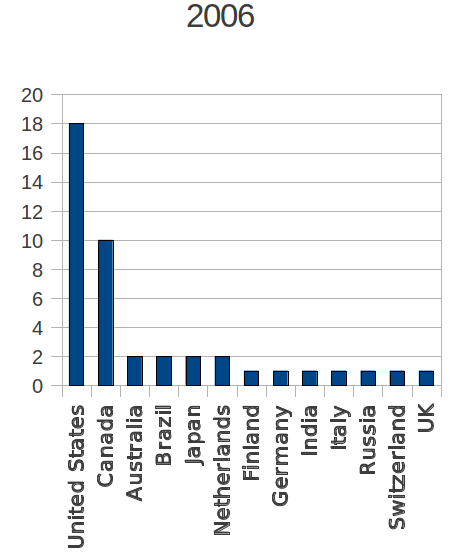
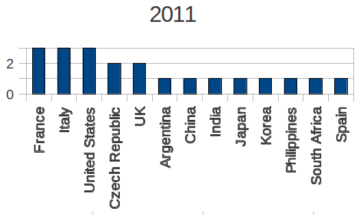
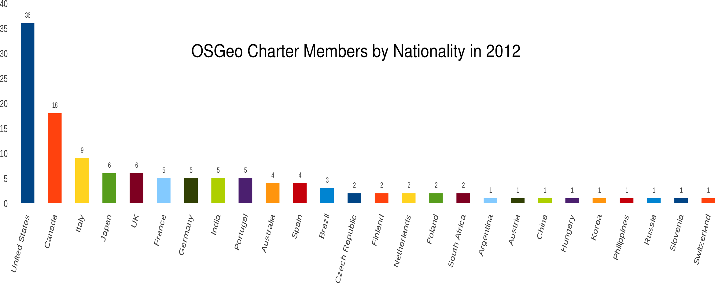
The diagrams show how the global distribution of Charter Members has evolved since the foundation in 2006. Initial Charter Membership represented 13 nationalities with almost two thirds (28 out of 43) coming from the USA and Canada. By 2011 these figure have changed considerably, Charter Members now represent 26 nations and Canadian and USA representation has dropped below 50% (54 out of 125) confirming that OSGeo is a truly global organization.
The Board of Directors
Each year Charter Members elect members into the OSGeo Board of Directors [3]. The term for a director is two years after which they have to be renominated and reelected if they wish to continue to serve OSGeo on the board. To ensure some continuity in the board the elections are staggered meaning that each year only half of the board is renewed.
The board of directors appoints the president who coordinates the board meetings, represents the organization to the outside and signs contracts in the name of the Foundation. The board of directors sets up the budget, hires staff and service providers, approves memoranda of understanding with friendly organizations and in general only takes decisions that for whichever reason cannot be taken in one of the committees or on the regular membership level. In general the OSGeo board of directors tries to not interfere with regular processes on the membership level. Wherever possible the modus operandi of OSGeo is do-ocratic.
The board of directors meets on a monthly basis usually on IRC and goes through the agenda which is maintained on the public Wiki. Meeting protocols are public, both in the protocol of the chat and as a summary compiled by the secretary. Sometimes the meetings are supported by a conference call to be able to talk through more complex questions. The board aims to meet in person once or twice a year. One of these meetings typically happens during the FOSS4G conference, the other meeting is coordinated individually. The Face to Face meetings have a more strategic character and sometimes the board also invites other OSGeo members to discuss the future of the Foundation. These meetings are very important to be able to develop opinions around more intricate topics and usually run for at least one full day.
New Directors
The last OSGeo elections took place in 2011 [4] and completed the existing board of directors by 5 new members.
- Peter Batty was the chair of the FOSS4G 2011 Local Organizing Committee in Denver, USA. He brings entrepreneurial competence to OSGeo from his time as CTO (Chief Technology Officer) at Intergraph and Smallworld. He currently works for Ubisense with a focus on using Open Source in a commercial context.
- Jo Cook from the UK works at Astun Technology as software integrator and project manager. She is founding member and chair of the UK Local Chapter which she has helped to grow right from inception.
- Mark Lucas is a founding member of OSGeo and already served on the board of directors from 2006 until 2008. He is Chief Scientist at Radiant Blue Technologies Inc. and long time contributor to the OSGeo project OSSIM [x].
- Michael Gerlek also is an OSGeo founding member and worked in the area of raster processing at Lizardtech for many years. Two years ago he founded his own company Flaxen Geo Consulting. He is OSGeo's Secretary and an active contributor to the Liblas [x] project.
- Jeff McKenna is an OSGeo founding member and has also been an integral part of the annual conference FOSS4G and its preceding UMN MapServer user meetings. He is long time contributor to the UMN MapServer project and offers his services under the label Gateway Geomatics.
The board is completed by the directors Arnulf Christl, president (metaspatial) , Daniel Morissette, treasurer (MapGears), Tim Schaub (OpenGeo), and Frank Warmerdam (Google).
Outgoing Directors
The following directors did not stand for re-election; hence ending their board mandate:
- Ravi Kumar
- Markus Neteler (GRASS GIS), a founding member of OSGeo, member in various committees - he concluded 5 years of continuous membership in the board
- Chris Schmidt (OpenLayers)
- Geoff Zeiss (Autodesk)
Termination of the Executive Director Position
In their face to face meeting in Denver, USA right after the FOSS4G conference the board of directors decided to terminate the full time staff position Executive Director. This decision was received with mixed feelings by the membership and needs some explanation. Taking all facts into account this decision was the most reasonable thing to do in the given circumstances. They can be summarized as follows:
- The ED had a vital role during inception and the first steps of building the foundation. The functions of this role are not required in this form anymore.
- The major part of OSGeo's financial assets were spent to fund this position. The consequence was that OSGeo was not able to fund other important areas. The new budget takes this into account and shifts funds to other areas of interest.
- The income through sponsorship did not live up to expectations.
- The existing full time staff position did not help to recruit new sponsors. Instead, income through sponsorship continually dropped over the past years.
- It became increasingly difficult to justify why one single full time employee consumed the larger part of OSGeo's budget while at the same time hundreds of volunteers spent many hours of their free time to further the mission of OSGeo.
The way forward will be to hire professionals for specific and clearly defined tasks which cannot be effectively done by a single individual, no matter how capable. These tasks will for example include book keeping, web design, marketing and communications, and maybe also fund raising. No single individual can do all of these things effectively.
Nother reason for the decision was that the annual FOSS4G conference will take place under more difficult circumstances in 2012. It will for the first time compete with two other large FOSS4G events, one taking place in North America in April the other one in May in Prague. Both will attract many European and North American attendees who so far made up a considerable number of paying attendees of the global FOSS4G but might not be able or willing to go to two international conferences in one year. In the past years the FOSS4G conference has been the main annual source of income for OSGeo and lacking this income requires that the board responsibly manage OSGeo's existing budget.
The new budget which has been adopted during the February 2012 face to face meeting in Seattle, USA takes these changes into account and allocates more funds to specific tasks. These range from marketing initiatives to hardware acquisition to support the project infrastructure. It also includes a traveling budget for a yet to be defined role called OSGeo Ambassadors who will official represent OSGeo at events all over the world. Again this is a task that cannot be done by a single employee located in western Canada. All of these changes support the global scope of OSGeo and might also help to increase the interest of potential sponsors.
FOSS4G
FOSS4G (the Free and Open Source Software for Geospatial [5]) is the annual OSGeo conference. The tradition of this conference predates the founcation of OSGeo itself. The first international conference around this topic was called the GRASS User Conference and took place in Trento, Italy in 2002. Another important event was the first UMN MapServer conference which took place in Minnesota, USA in 2003. The first FOSS4G conference under this name took place in in Bangkok, Thailand in 2004. GRASS, UMN MapServer and many other Open Source geospatial projects joined forces in 2006 and founded OSGeo with one major focus on planning and hosting a common annual conference that was intended to travel around the world.
So far the annual FOSS4G conference took place in Switzerland (2006), Canada, South Africa, Australia, Spain and the USA (2011). Besides the global FOSS4G other more locally focused conferences started to emerge, often with similar content but local scope and language. These include the UMN MapServer User conference in Brazil (2005), FOSSGIS in Germany (since 2003), SIGTE in Spain, geo-IT in Italy, or FOSS4G in Japan and Portugal – just to name a few.
The location of the annual FOSS4G conference was selected following several stages of a clearly defined process. OSGeo first publishes a Call for Location (CfL) for which any group interested in hosting the conference can apply. To ensure global coverage the CfL focuses on specific regions. So far the conference rotates every three years between Europe, Northern America and a region that has not yet been visited by FOSS4G. In the next step the OSGeo Conference Committee selects two candidate who then have to prepare a program, time schedule and budget. The conference committee will then evaluate the proposal and recommend the corresponding Local Organizing Committee to the Board of Directors who vote on acceptance. Depending on the venue, organizer and financial circumstances OSGeo then can commit to a financial obligation in return for the surplus generated by the conference. In past years this income has been the major source of funding of the Foundation.
In the sixth year of this regular annual conference rotation it becomes apparent that a three year rotation does not satisfy the global need for geospatial Open Source conferences. The board therefore decided to support more than just one annual, global event and broaden the scope of FOSS4G. OSGeo will continue to declare one annual conference as the main event and annual "Meeting of the Tribes". This event will see the Sol Katz Award for exceptional contribution to the Free and Open Source geospatial community, the OSGeo Annual General Meeting and the Board of Directors Face to Face meeting. This will hopefully continue to be "The Event" and attract core developers from all projects to learn about newest technology and continue to improve cross-project collaboration – a central element of OSGeo's mission. Time will tell whether this will work out and the main FOSS4G event will continue to attract the leaders of the highest quality Open Source software.
2011 in Denver
The latest edition of FOSS4G in Denver, USA was an exceptional success. With most presentation and workshop submissions and the highest number of attendees it broke all FOSS4G records so far. It was also the first event which hosted a pre-conference day for Open Source beginners. During this day attendees received an introduction to all aspects relevant to understand the FOSS model including licensing, the development model and associated business models.
Regional FOSS4G Conferences
The first regional conferences officially hosted by OSGeo will take place in North America (FOSS4G NA [6]) and in Prague in the Czech Republic. The North American Conference is a follow-up from the very successful event in Denver. It attracted more than 350 attendees to come to Washington and learn about the most recent development. The other major conference is the Central- and Eastern Europe (FOSS4G CEE [7]) edition of FOSS4G. It will be co-hosted with the annual Geoinformatics meeting. Both conferences will primarily attract local attendees and businesses.
OGC und OSM meetings
In 2011 the Denver regionin the USA for three weeks was a geospatial epicenter with the main annual meeting "State of the Map" [8] of the OpenStreetMap project right before FOSS4G. One week later the Open Geospatial Consortium (OGC) met in Boulder for their 78th Technical Committee [9] meeting. These quarterly week-long work meetings are attended by members of OGC to work on geospatial standards, for example the well known interface standards WMS and WFS and the data formats GML and KML. Not many managed to visit all three events but those who did took note of considerable overlap in several areas of work. Increasingly OSGeo has become a binding element between OpenStreetMap and the OGC, if only be providing software for the first which implement standards of the latter and allow users to seamlessly integrate OpenStreetMap with their own data through international standards.
Other Appearances of OSGeo
OSGeo has become a regular attendant for many other events. Typically the first time OSGeo appears at a new event is through a presentation on the general topic of Open Source Geospatial by an officer of OSGeo. In 2011 the president of OSGeo gave more than 30 presentations [10] throughout the year and all around the world. In some cases OSGeo is invited to give a keynote, sometimes the organizers dedicate one track to Open Source Geospatial. OSGeo was also present at several trade fairs, often organized by Local Chapters.
The German speaking Local Chapter FOSSGIS each year organizes a large OSGeo booth at [[Intergeo [11]]], the largest world-wide geospatial trade fair. The booth is equipped with a presentation area where software projects and service providers give more than 35 presentations throughout the day. The project area provides presentation space for OSGeo software projects, OpenStreetMap and the FOSSGIS membership association. At the annual AGIT event, a more scientifically oriented event organized by the geoinformatic department of the University of Salzburg in Austria FOSSGIS operates the OSGeo day.
United Nations
One highlight for the president of OSGeo in 2012 was the invitation to the first meeting of the High Level Global Geospatial Information Management (GGIM). OSGeo was invited to this event along with other global players to inform UN member states about current trends in the Geo – and GIS industry. The illustrious group of 20 invited representatives besides OSGeo included Google, Oracle, Hexagon, Esri, Smallworld, ERDAS, Bentley, Samsung SDS, Pitney Bowes and others. For 2012 GGIM plans to create a new information resource for member states and OSGeo has been invited to participate in this process.
Local Chapters
A lot of activities have been organizes by many OSGeo [[Local Chapters [14]]] in 2011. Literally hundreds of events were organized throughout the world, ranging from informal regular's tables to full fledged code sprints and local conferences in more than 30 nations. OSGeo could welcome 8 communities as new officially recognized OSGeo Local Chapters representing the increasingly global scope of the truly multinational Foundation. For more details about all activities please refer to their corresponding web sites, most of which (should) be linked from the Local Chapters overview page.
Links
This link list is provided for print versions of this repport.
- [0] http://www.osgeo.org/
- [1] http://arnulf.us/publications/bericht_von_der_osgeo_2011_arnulf-christl.odt
- [2] http://www.osgeo.org/charter_members
- [3] http://www.osgeo.org/content/foundation/board_and_officers.html
- [4] http://wiki.osgeo.org/wiki/Election_2011
- [5] http://wiki.osgeo.org/wiki/FOSS4G
- [6] http://wiki.osgeo.org/wiki/FOSS4G_NA_2012
- [7] http://foss4g-cee.org/
- [8] http://wiki.openstreetmap.org/wiki/State_Of_The_Map_2011
- [9] http://www.opengeospatial.org/event/1109tc
- [10] http://arnulf.us/Events
- [11] http://www.intergeo.de/
- [12] http://www.agit.at
- [13] http://ggim.un.org/
- [14] http://wiki.osgeo.org/wiki/Category:Local_Chapters


