Search results
Jump to navigation
Jump to search
- ...metadata. Permission is hereby granted to you by the author (s) to use the data for any purpose, to study, adapt to your needs, copy, distribute, enhance, ...e and to the absence of any warranty; and give any other recipients of the data a copy of this licence included as metadata.6 KB (1,071 words) - 19:18, 10 August 2006
- * Cache DBF record data for the current SHP record * Improved Label Theme "along lines" option, to better suit contour data1 KB (162 words) - 03:28, 23 February 2015

File:Ottawa Chapter Tutorial 4 Building National Framework.pdf How I Continued My Love Affair With Free Geospatial Data in Canada(179 KB) - 10:41, 21 September 2006- This is a planning space for what the group in the [[Public Geospatial Data Project]] would like to see on its website. Welcome to the home page of the [[Public Geospatial Data Committee]] at the Open Source Geospatial Foundation. This is a group that1 KB (166 words) - 08:38, 23 August 2007
- == EGU Open Science & Data Help Desk 2024 == ...relevant OSGeo-related aspects, tasks, ressources and stakeholders for the Data Help Desk.2 KB (294 words) - 02:51, 22 March 2024
- ...find it fascinating and want to try using the open source applications and data in practice for my work. ...gy Register" [http://www.ben-project.eu], which uses OS GIS technology and data to produce biomass potential maps and signposting tool for bioenergy projec473 bytes (74 words) - 08:38, 13 July 2010
- ...a, providing a standards-based metadata and catalogue component of spatial data infrastructures. ...a, providing a standards-based metadata and catalogue component of spatial data infrastructures.2 KB (260 words) - 03:42, 11 April 2013
File:Ottawa Chapter Tutorial 3 Building Ottawa.pdf How I learned to Stop Worrying and Love Mining for Free Geospatial Data in Canada(179 KB) - 10:38, 21 September 2006- Self motivated developer and OS volunteer with geo data processing skills.74 bytes (11 words) - 08:43, 27 July 2017
- ...dynamic spatial maps over the Internet. It is used for publishing spatial data and interactive mapping applications to the web. Check out @mapserver_osgeo GDAL is a great library for more than 200 raster and vector geospatial data formats.Check out @gdalorg and get amazing tips from @gdaltips2 KB (300 words) - 09:58, 28 January 2022
- ***''%\minisec{View data}'' ***''%\minisec{Explore data and compose maps''3 KB (391 words) - 14:30, 4 March 2009
- ''Data: areawater_merge''772 bytes (90 words) - 15:29, 30 September 2009
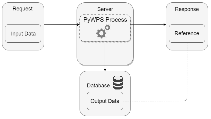
File:DatabaseStorage.png This image shows the option I added for storing output data(708 × 399 (25 KB)) - 10:36, 13 August 2018- IT boffin; casual GIS data manipulator67 bytes (10 words) - 08:51, 12 October 2017
- ...olve problems and as a vital skill to be taught to anyone who uses spatial data to make decisions. I am a Chartered Geographer (GIS) and Fellow of the Roya ...ographic design and analysis & presentation of small area change in Census data. Additionally I teach GIS to students and non-students a range of GIS skil769 bytes (129 words) - 13:54, 25 April 2019
- ...tware is suitable to publish data in compliance with the INSPIRE directive data schemas. ...rk on example use cases that demonstrate the creation of INSPIRE compliant data.3 KB (369 words) - 09:02, 18 February 2014
- == Basic Project Data ==1 KB (155 words) - 18:16, 19 March 2016
- ...iew provides an OpenLayers based map interface to allow exploration of the data served by GeoServer. == Data on Arramagong 2008 ==3 KB (434 words) - 13:55, 3 September 2009
- Calgary, AB, SAIT Polytechnic Specialties: Arc GIS, Cartography, Data Analysis, Python86 bytes (11 words) - 12:45, 5 April 2020
- Metadata Librarian for Geospatial and Scientific Data at Stanford University Libraries86 bytes (11 words) - 09:28, 13 May 2017
